Paradise, Mono County, California

Last updated

Paradise
Mono County California Incorporated and Unincorporated areas Paradise Highlighted 0655528.svg
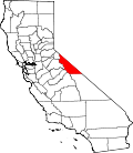
Location in Mono County and the state of California
USA California location map.svg
Red pog.svg
Paradise
Usa edcp location map.svg
Red pog.svg
Paradise
Coordinates: 37°29′58″N118°36′16″W / 37.49944°N 118.60444°W / 37.49944; -118.60444
Country United States
State California
County Mono
Area
[1]
  Total4.352 sq mi (11.272 km2)
  Land4.352 sq mi (11.272 km2)
  Water0 sq mi (0 km2)
Elevation
[2]
5,230 ft (1,590 m)
Population
 (2020) [3]
  Total174
  Density40/sq mi (15/km2)
Time zone UTC-8 (Pacific (PST))
  Summer (DST) UTC-7 (PDT)
ZIP Code
93514 (Bishop)
Area code(s) 760; 442
GNIS feature ID2583105 [2]

Paradise is an unincorporated community and census-designated place (CDP) [2] that is the southernmost community in Mono County, California, United States. [4] The population was 174 at the 2020 census. [3]

Contents

Geography

Located in the southwest part of the county, Paradise functions as a bedroom community for workers in Bishop (15 miles (24 km) to the southeast) and Mammoth Lakes (26 miles (42 km) to the northwest), and as a home for retirees. [4] Geographically, it sits near the bottom of the Sherwin Grade, which divides Round Valley in Inyo County from Long Valley in Mono County. [4] Neighboring communities include Wheeler Crest to the west, Swall Meadows and Pinon Ranch to the north. [4]

According to the United States Census Bureau, the CDP covers an area of 4.4 square miles (11 km2), all of it land. [1]

Demographics

2010

The 2010 United States Census [5] reported that Paradise had a population of 153. The population density was 35.2 inhabitants per square mile (13.6/km2). The racial makeup of Paradise was 130 (85.0%) White, 0 (0.0%) African American, 2 (1.3%) Native American, 6 (3.9%) Asian, 0 (0.0%) Pacific Islander, 5 (3.3%) from other races, and 10 (6.5%) from two or more races. Hispanic or Latino of any race were 14 persons (9.2%).

The Census reported that 153 people (100% of the population) lived in households, 0 (0%) lived in non-institutionalized group quarters, and 0 (0%) were institutionalized.

There were 74 households, out of which 11 (14.9%) had children under the age of 18 living in them, 49 (66.2%) were opposite-sex married couples living together, 2 (2.7%) had a female householder with no husband present, 0 (0%) had a male householder with no wife present. There were 2 (2.7%) unmarried opposite-sex partnerships, and 1 (1.4%) same-sex married couples or partnerships. 20 households (27.0%) were made up of individuals, and 10 (13.5%) had someone living alone who was 65 years of age or older. The average household size was 2.07. There were 51 families (68.9% of all households); the average family size was 2.47.

The population was spread out, with 19 people (12.4%) under the age of 18, 2 people (1.3%) aged 18 to 24, 23 people (15.0%) aged 25 to 44, 76 people (49.7%) aged 45 to 64, and 33 people (21.6%) who were 65 years of age or older. The median age was 52.9 years. For every 100 females, there were 104.0 males. For every 100 females age 18 and over, there were 97.1 males.

There were 87 housing units at an average density of 20.0 per square mile (7.7/km2), of which 71 (95.9%) were owner-occupied, and 3 (4.1%) were occupied by renters. The homeowner vacancy rate was 1.4%; the rental vacancy rate was 25.0%. 149 people (97.4% of the population) lived in owner-occupied housing units and 4 people (2.6%) lived in rental housing units.

2000

The 2000 United States Census reported the population of Paradise to be 124. [4] For 2003, the California Department of Finance estimated the population to be 126. [4] In 2000, 2% of the population was under 5 years old, 6% were from 5 to 17, 64% were from 18 to 64, and 28% were over 65. [4] The median age was 57. [4] Paradise's percentage of seniors and median age both exceeded the county averages. [4] Eighty-six percent of the households were owner occupied and 14% were rented. [4] Sixty percent of Paradise's 132 lots have been developed, and there are current plans to 53 luxury homes on one undeveloped parcel. [4]

Tourism

There is a commercial tourist industry in Paradise. The Paradise Lodge is a designated rural resort that contains 17 cabins and a restaurant. [4]

Fire Protection District

Paradise is the seat of the Paradise Fire Protection District, which was established in 1982. [4] The fire protection district covers an area of approximately 1 square mile (2.6 km2) and includes areas adjacent to Paradise, such that the fire district's population was 170. [4]

Related Research Articles

<span class="mw-page-title-main">Bear Valley, Alpine County, California</span> Census-designated place in California, United States

Bear Valley is a census-designated place in Alpine County, California, best known as the location of the Bear Valley ski area. The population was 121 at the 2010 census, down from 133 at the 2000 census.

<span class="mw-page-title-main">Auberry, California</span> Census-designated place in California, United States

Auberry is a census-designated place (CDP) in Fresno County, California, United States. The population was 2,369 at the 2010 census, up from 2,053 at the 2000 census. Auberry is located on Little Sandy Creek 9.5 miles (15 km) west of Shaver Lake Heights, at an elevation of 2,018 feet (615 m).

<span class="mw-page-title-main">Bowles, California</span> Census-designated place in California, United States

Bowles is a census-designated place (CDP) in Fresno County, California, United States. The population was 166 at the 2010 census, down from 182 at the 2000 census. Bowles is located 11 miles (18 km) south of downtown Fresno, at an elevation of 279 feet.

<span class="mw-page-title-main">Raisin City, California</span> Census-designated place in California, United States

Raisin City is a census-designated place (CDP) in Fresno County, California, United States. The population was 380 at the 2010 census, up from 165 at the 2000 census. Raisin City is located 13 miles (21 km) south-southwest of downtown Fresno, at an elevation of 236 feet.

<span class="mw-page-title-main">Redway, California</span> Census-designated place in California, United States

Redway is a census-designated place (CDP) in Humboldt County, California, United States. Redway is located 2.25 miles (3.6 km) northwest of Garberville, at an elevation of 538 feet (164 m). The population was 1,225 at the 2010 census, up from 1,188 at the 2000 census. Redway is also home to Redway Elementary School, with grades K–6.

<span class="mw-page-title-main">Lucerne, Lake County, California</span> Census-designated place in California, United States

Lucerne is a census-designated place (CDP) in Lake County, California, United States. Lucerne is located 7.25 miles (12 km) east-northeast of Lakeport, at an elevation of 1329 feet. The population was 235 in 1871, 2,870 at the 2000 census and 3,067 at the 2010 census.

<span class="mw-page-title-main">Lake Wildwood, California</span> Census-designated place in California, United States

Lake Wildwood is a census-designated place (CDP) in Nevada County, California, United States. The population was 4,991 at the 2010 census, up from 4,868 at the 2000 census.

<span class="mw-page-title-main">Indian Falls, California</span> Census-designated place in California, United States

Indian Falls is a census-designated place (CDP) in Plumas County, California, United States. The population was 10 at the 2020 census, down from 54 at the 2010 census.

<span class="mw-page-title-main">El Cerrito, Riverside County, California</span> Census-designated place in Riverside County, California, United States

El Cerrito is a census-designated place (CDP) in Riverside County, California, United States. It is an unincorporated area mostly surrounded by the city of Corona. The population was 5,100 at the 2010 census, up from 4,590 at the 2000 census.

<span class="mw-page-title-main">Morongo Valley, California</span> Census-designated place in California, United States

Morongo Valley is a census-designated place (CDP) on State Route 62 in San Bernardino County, California, United States. The population was 3,552 at the 2010 census, up from 1,929 at the 2000 census. The town is bordered by Yucca Valley, California.

<span class="mw-page-title-main">Bonsall, California</span> Census-designated place in California, United States

Bonsall is a census-designated place (CDP) in San Diego County, California. The population was 3,982 at the 2010 census, up from 3,401 at the 2000 census.

<span class="mw-page-title-main">Country Club, California</span> Census-designated place in California, United States

Country Club is a census-designated place (CDP) in San Joaquin County, California, United States. The population was 9,379 at the 2010 census, down from 9,462 at the 2000 census. It comprises an unincorporated "island" within the City of Stockton.

<span class="mw-page-title-main">Mono Vista, California</span> Census-designated place in California, United States

Mono Vista is a census-designated place (CDP) in Tuolumne County, California, United States. The population was 3,127 at the 2010 census, up from 3,072 at the 2000 census.

<span class="mw-page-title-main">Lakeland Village, California</span> Census-designated place in California, United States

Lakeland Village is a census-designated place (CDP) in Riverside County, California, United States. The population was 11,541 at the 2010 census, more than double the 5,626 reported at the 2000 census.

<span class="mw-page-title-main">Coleville, California</span> Census-designated place in California, United States

Coleville is an unincorporated community and census-designated place (CDP) in Mono County, California, United States. It is located at an elevation of 5,141 feet (1,567 m) in the Antelope Valley on the West Walker River. The population was 419 at the 2020 census, down from 495 at the 2010 census.

<span class="mw-page-title-main">Swall Meadows, California</span> Census-designated place in California, United States

Swall Meadows is an unincorporated community and census-designated place (CDP) in southern Mono County, California, United States. The population was 178 as of the 2020 census. The community is residential, including second homes and a volunteer fire department, but no commercial development. The ZIP Code is 93514. The community is inside area code 760.

<span class="mw-page-title-main">Aspen Springs, California</span> Census-designated place in California, United States

Aspen Springs is an unincorporated community and census-designated place (CDP) in Mono County, California, United States. It lies at an elevation of 7,109 feet (2,167 m). The population was 70 at the 2020 census.

<span class="mw-page-title-main">Mono City, California</span> Census-designated place in California, United States

Mono City is an unincorporated community and census-designated place (CDP) in Mono County, California, United States. It lies north of Mono Lake at the base of the Sierra Nevada at the junction of U.S. Route 395 and California State Route 167. The ZIP Code is 93541; mail to Mono City should be addressed Lee Vining. The population was 224 at the 2020 census, up from 172 at the 2010 census.

<span class="mw-page-title-main">Topaz, California</span> Census-designated place in California, United States

Topaz is an unincorporated community and census-designated place (CDP) in Mono County, California, United States. It is located 3 miles (5 km) north of Coleville. Topaz's ZIP Code is 96133. The population was 150 at the 2020 census.

<span class="mw-page-title-main">Walker, Mono County, California</span> Census-designated place in California, United States

Walker is an unincorporated community and census-designated place (CDP) in Mono County, California, United States. It is located 3 miles (5 km) south of Coleville. The ZIP Code is 96107, and mail to Walker should be addressed Coleville.

References

  1. 1 2 "2022 U.S. Gazetteer Files: California". United States Census Bureau. Retrieved November 3, 2022.
  2. 1 2 3 U.S. Geological Survey Geographic Names Information System: Paradise, Mono County, California
  3. 1 2 "P1. Race – Paradise CDP, California: 2020 DEC Redistricting Data (PL 94-171)". U.S. Census Bureau. Retrieved November 3, 2022.
  4. 1 2 3 4 5 6 7 8 9 10 11 12 13 14 Report of the Mono County Planning Department regarding the Paradise Fire Protection District Archived 2009-06-21 at the Wayback Machine
  5. "2010 Census Interactive Population Search: CA - Paradise CDP". U.S. Census Bureau. Archived from the original on July 15, 2014. Retrieved July 12, 2014.