
A hot tub is a large tub or small pool full of water used for hydrotherapy, relaxation or pleasure. Some have powerful jets for massage purposes. Hot tubs are sometimes also known as spas or by the trade name Jacuzzi.
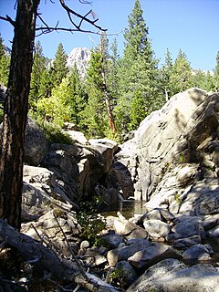
Grover Hot Springs State Park is a state park of California, USA, containing natural hot springs on the eastern side of the Sierra Nevada. Park amenities include a swimming pool complex fed by the hot springs, as well as a campground, picnic area, and hiking trails. The 553-acre (224 ha) park was established in 1959.
Kingston is a former town that is no longer in existence. Originally in Fresno County, until 1909 when Fresno County lands in the vicinity, south of Kings river were transferred to Kings County, California. It was located on the south bank of the Kings River 8.5 miles (13.7 km) northwest of Hanford at Whitmore's Ferry.
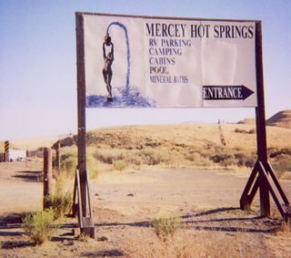
Mercey Hot Springs is an unincorporated community in the Little Panoche Valley of Fresno County, central California, about 60 miles (97 km) west-southwest of Fresno. It is a resort along South Fork Little Panoche Creek and the Little Panoche Road located at the western edge of Fresno County.

Benton is a census-designated place in Mono County, California, United States. It is located 3 miles (4.8 km) east-northeast of the community of Benton Hot Springs and 32 miles (51 km) north of the community of Bishop, at an elevation of 5387 feet. The population was 280 at the 2010 census, up from 196 reported at 2000 by Mono County.

Tub Springs State Wayside is a state park in the U.S. state of Oregon, administered by the Oregon Parks and Recreation Department.

Petersburg is a former settlement in Kern County, California. It was located on Greenhorn Creek 4.5 miles (7.2 km) west-northwest of Miracle Hot Springs, at an elevation of 4731 feet. Petersburg still appeared on maps as of 1956.

Drakesbad is an unincorporated community in Plumas County, California. It lies at an elevation of 5705 feet. Drakesbad is located on Hot Springs Creek, 5.5 miles (8.9 km) west of Mount Harkness.
Keough Hot Springs is an unincorporated community in Inyo County, California. It is located near the western edge of the Owens Valley 7.5 miles (12 km) south of Bishop, at the springs called Keough Hot Springs, at an elevation of 4209 feet.
Scovern Hot Springs is a former settlement in the Kern River Valley of the Southern Sierra Nevada, in Kern County, California.
Miracle Hot Springs is an unincorporated community in the Kern River Valley, in Kern County, California. It is located on the Kern River 14 miles (23 km) southeast of Glennville, at an elevation of 2,382 feet (726 m).
Harbin Springs is an unincorporated community in Lake County, California. It is located 3.5 miles (5.6 km) east-southeast of Whispering Pines, at an elevation of 1555 feet. It is the site of the Harbin Hot Springs.
Seigler Springs is an unincorporated community in Lake County, California. It is located 1 mile (1.6 km) east of Seigler Mountain, 5 miles (8 km) south of Clear Lake and 20 miles (32 km) northeast of Healdsburg, at an elevation of 2251 feet.
Orrs Springs is an unincorporated community in Mendocino County, California. It is located 15 miles (24 km) almost directly north of Boonville, at an elevation of 1001 feet. However, it is accessible from Ukiah by following Orr Springs Rd.
Tassajara Hot Springs is an unincorporated community in Monterey County, California, located 9 miles (14 km) east-northeast of Partington Point, at an elevation of 1637 feet.

California Hot Springs is a census-designated place in Tulare County, California, United States. California Hot Springs is 20 miles (32 km) east of Ducor. California Hot Springs has a post office with ZIP code 93207. The population was 37 at the 2010 census.
Hot Springs is an unincorporated community in Plumas County, California. It lies at an elevation of 2815 feet. Hot Springs is located 2 miles (3.2 km) east of Twain.

The Valley Fire was a wildfire during the 2015 California wildfire season that started on September 12 in Lake County, California. It began shortly after 1:00 pm near Cobb with multiple reports of a small brush fire near the intersection of High Valley and Bottlerock Roads. It quickly spread and by 6:30 PM PDT, it had burned more than 10,000 acres (40 km2). By Sunday, the thirteenth of September, the fire had reached 50,000 acres (202 km2) and had destroyed much of Cobb, Middletown, Whispering Pines, and parts in the south end of Hidden Valley Lake. The fire ultimately spread to 76,067 acres (308 km2), killed four people and destroyed nearly 2,000 buildings, before it was fully contained on October 15, 2015, causing at least $921 million in insured property damage. At the time, the fire was the third-most destructive fire in California history, based on the total structures burned.

Hookers Hot Springs is a populated place in Cochise County, Arizona, United States.
Whitmire Spring is a spring in Hidalgo County, New Mexico. Correctly named on the Playas Lake South U. S. topographic map, it is mistakenly called Whitmore Spring on the U.S. Geological Survey Geographic Names Information System. The spring was named after J. B. Whitmire, a rancher in the 1880s, owner of the Whitmire Ranch. Whitmire Spring lies at an elevation of 4,291 feet / 1,308 meters, on the west shore of Playas Lake, near the site of the Whitmire Ranch. Whitmire Spring is one of a number of springs and seeps bordering the western edge of Playas Lake. Its water has its source in the Animas Mountains nearby to the west.


