Mexhoma, Oklahoma | |
|---|---|
 Mexhoma in April 2024 | |
 Mexhoma | |
| Coordinates: 36°43′10″N102°59′05″W / 36.71944°N 102.98472°W | |
| Country | United States |
| State | Oklahoma |
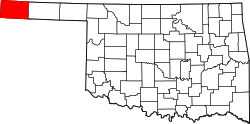
| County | Cimarron |
| Elevation | 4,826 ft (1,471 m) |
| Time zone | UTC-6 (Central (CST)) |
| • Summer (DST) | UTC-5 (CDT) |
| Area code | 580 |
| GNIS feature ID | 1100631 [1] |
Mexhoma is an unincorporated community in Cimarron County, in the U.S. state of Oklahoma. [1] Located at the crossroads of N0020 Rd and E0200 Rd, [2] the locale is about 27.3 miles west of the county seat of Boise City, [3] and just one mile east of the New Mexico border. [2]