Sturgis, Oklahoma | |
|---|---|
 Sturgis | |
| Coordinates: 36°53′38″N102°04′13″W / 36.89389°N 102.07028°W | |
| Country | United States |
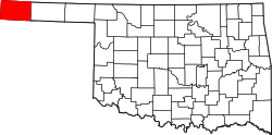
| State | Oklahoma |
| County | Cimarron |
| Elevation | 3,770 ft (1,150 m) |
| Time zone | UTC-6 (Central (CST)) |
| • Summer (DST) | UTC-5 (CDT) |
| Area code | 580 |
| GNIS feature ID | 1100860 [1] |
Sturgis is an unincorporated community in northeastern Cimarron County, Oklahoma, United States. [1] It is located on a railroad just north of U.S. Route 56. [2] [3] It is approximately 14 miles southwest of Elkhart, Kansas, [4] and less than 28 miles northeast of the Cimarron County seat, Boise City. [5]
Sturgis was connected to both Elkhart and Boise City by the Elkhart and Santa Fe Railway (both leased to and a wholly owned subsidiary of the Atchison, Topeka and Santa Fe Railway), [6] which came through in 1925. [7] The line is now part of the Cimarron Valley Railroad. [8]
The Tri-State Point where Oklahoma, Kansas and Colorado come together, known as Eight Mile Corner, is about nine miles north of Sturgis. [9] [10]