Mezhdurechensky District, Kemerovo Oblast

Last updated
Mezhdurechensky District
Междуреченский район(Russian)
Location of Mezhdurechensk (Kemerovo Oblast).svg
Location of Mezhdurechensky District in Kemerovo Oblast
Coordinates: 53°41′10″N88°03′50″E / 53.686°N 88.064°E / 53.686; 88.064 Coordinates: 53°41′10″N88°03′50″E / 53.686°N 88.064°E / 53.686; 88.064
Nature Zuby 2.jpg
Podnebesnye Zubya Nature Park,
in Mezhdurechensky District
Location
Country Russia
Federal subject Kemerovo Oblast [1]
Administrative structure (as of November 2012)
Administrative center city of  Mezhdurechensk [1]
Inhabited localities: [1]
Rural localities 11
Municipal structure (as of November 2012)
Municipally incorporated as Mezhdurechensky Urban Okrug [2]
Statistics
Population (2010 Census) 2,268 inhabitants [3]
 Urban0%
 Rural100%
Time zone KRAT (UTC+07:00) [4]
Official website
Mezhdurechensky District on WikiCommons

Mezhdurechensky District (Russian : Междуре́ченский райо́н) is an administrative district (raion), one of the nineteen in Kemerovo Oblast, Russia. [1] It is located in the southeast of the oblast. Its administrative center is the city of Mezhdurechensk (which is not administratively a part of the district). [1] Population: 2,268(2010 Census); [3] 2,658 (2002 Census). [5]

Russian language East Slavic language

Russian is an East Slavic language, which is official in the Russian Federation, Belarus, Kazakhstan and Kyrgyzstan, as well as being widely used throughout Eastern Europe, the Baltic states, the Caucasus and Central Asia. It was the de facto language of the Soviet Union until its dissolution on 25 December 1991. Although nearly three decades have passed since the breakup of the Soviet Union, Russian is used in official capacity or in public life in all the post-Soviet nation-states, as well as in Israel and Mongolia.

A raion is a type of administrative unit of several post-Soviet states. The term is from the French "rayon", which is both a type of a subnational entity and a division of a city, and is commonly translated in English as "district".

Contents

Administrative and municipal status

Within the framework of administrative divisions, Mezhdurechensky District is one of the nineteen in the oblast. [1] The city of Mezhdurechensk serves as its administrative center, despite being incorporated separately as a town under oblast jurisdiction—an administrative unit with the status equal to that of the districts. [1]

Mezhdurechensk, Kemerovo Oblast City in Kemerovo Oblast, Russia

Mezhdurechensk is a city in Kemerovo Oblast, Russia. Population: 101,678 (2010 Census); 101,987 (2002 Census); 107,014 (1989 Census).

City of federal subject significance is an umbrella term used to refer to a type of an administrative division of a federal subject of Russia which is equal in status to a district but is organized around a large city; occasionally with surrounding rural territories.

As a municipal division, the territory of the administrative district and the territory of Mezhdurechensk City Under Oblast Jurisdiction are incorporated together as Mezhdurechensky Urban Okrug. [2]

Mezhdurechensky Urban Okrug is a municipal formation in Kemerovo Oblast, Russia, one of the sixteen urban okrugs in the oblast. Its territory consists of the territories of two administrative divisions of Kemerovo Oblast—Mezhdurechensky District and Mezhdurechensk City Under Oblast Jurisdiction.

Related Research Articles

Belovsky District Wikipedia disambiguation page

Belovsky District is the name of several administrative and municipal districts in Russia.

Guryevsky District Wikimedia list article

Guryevsky District is the name of several administrative and municipal districts in Russia.

Mezhdurechensky District Wikimedia disambiguation page

Mezhdurechensky District is the name of several administrative and municipal districts in Russia:

Yurginsky District Wikipedia disambiguation page

Yurginsky District is the name of several administrative and municipal districts in Russia:

Prokopyevsk City in Kemerovo Oblast, Russia

Prokopyevsk is a city in Kemerovo Oblast, Russia. Population: 210,130 (2010 Census); 224,597 (2002 Census); 273,838 (1989 Census).

Leninsk-Kuznetsky (city) City in Kemerovo Oblast, Russia

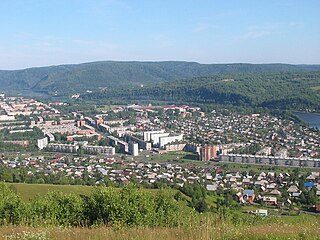
Leninsk-Kuznetsky, known as Kolchugino until 1925, is a city in Kemerovo Oblast, Russia, located on both banks of the Inya River. Population: 101,666 (2010 Census); 112,253 (2002 Census); 165,487 (1989 Census); 128,000 (1972); 83,000 (1939); 20,000 (1926).

Yurga Town in Kemerovo Oblast, Russia

Yurga is a town in Kemerovo Oblast, Russia, located on the Tom River. Population: 81,533 (2010 Census); 85,555 (2002 Census); 93,202 (1989 Census).

Salair (town) Town in Kemerovo Oblast, Russia

Salair is a town administratively subordinated to Guryevsk Town Under Oblast Jurisdiction in Kemerovo Oblast, Russia, located 210 kilometers (130 mi) south of Kemerovo, the administrative center of the oblast. Population: 8,262 (2010 Census); 9,472 (2002 Census); 11,452 (1989 Census).

Kaltan Town in Kemerovo Oblast, Russia

Kaltan is a town in Kemerovo Oblast, Russia, located on the Kondoma River, 338 kilometers (210 mi) south of Kemerovo, the administrative center of the oblast. Population: 21,892 (2010 Census); 25,591 (2002 Census); 25,369 (1989 Census).

Krapivinsky District District in Kemerovo Oblast, Russia

Krapivinsky District is an administrative district (raion), one of the nineteen in Kemerovo Oblast, Russia. As a municipal division, it is incorporated as Krapivinsky Municipal District. It is located in the center of the oblast. The area of the district is 6,900 square kilometers (2,700 sq mi). Its administrative center is the urban locality of Krapivinsky. Population: 24,533 (2010 Census); 27,658 ; 31,357 (1989 Census). The population of the administrative center accounts for 30.4% of the district's total population.

Novokuznetsky District District in Kemerovo Oblast, Russia

Novokuznetsky District is an administrative district (raion), one of the nineteen in Kemerovo Oblast, Russia. As a municipal division, it is incorporated as Novokuznetsky Municipal District. It is located in the center of the oblast and spans it from border to border in the southwest-northeast direction. The area of the district is 13,039.5989 square kilometers (5,034.6173 sq mi). Its administrative center is the city of Novokuznetsk. As of the 2010 Census, the total population of the district was 50,681.

Tashtagolsky District District in Kemerovo Oblast, Russia

Tashtagolsky District is an administrative district (raion), one of the nineteen in Kemerovo Oblast, Russia. As a municipal division, it is incorporated as Tashtagolsky Municipal District. It is located in the south of the oblast. The area of the district is 11,383 square kilometers (4,395 sq mi). Its administrative center is the town of Tashtagol. Population: 31,895 (2010 Census); 34,545 ; 37,816 (1989 Census).

Topkinsky District District in Kemerovo Oblast, Russia

Topkinsky District is an administrative district (raion), one of the nineteen in Kemerovo Oblast, Russia. As a municipal division, it is incorporated as Topkinsky Municipal District. It is located in the northwest of the oblast. The area of the district is 2,774 square kilometers (1,071 sq mi). Its administrative center is the town of Topki. Population: 16,246 (2010 Census); 18,077 ; 19,018 (1989 Census).

Tyazhinsky District District in Kemerovo Oblast, Russia

Tyazhinsky District is an administrative district (raion), one of the nineteen in Kemerovo Oblast, Russia. As a municipal division, it is incorporated as Tyazhinsky Municipal District. It is located in the northeast of the oblast. The area of the district is 3,531 square kilometers (1,363 sq mi). Its administrative center is the urban locality of Tyazhinsky. Population: 25,597 (2010 Census); 32,782 ; 32,574 (1989 Census). The population of the administrative center accounts for 43.4% of the district's total population.

Yashkinsky District District in Kemerovo Oblast, Russia

Yashkinsky District is an administrative district (raion), one of the nineteen in Kemerovo Oblast, Russia. As a municipal division, it is incorporated as Yashkinsky Municipal District. It is located in the northwest of the oblast. The area of the district is 3,484 square kilometers (1,345 sq mi). Its administrative center is the urban locality of Yashkino. Population: 30,856 (2010 Census); 34,131 ; 37,446 (1989 Census). The population of Yashkino accounts for 47.7% of the district's total population.

Yurginsky District, Kemerovo Oblast District in Kemerovo Oblast, Russia

Yurginsky District is an administrative district (raion), one of the nineteen in Kemerovo Oblast, Russia. As a municipal division, it is incorporated as Yurginsky Municipal District. It is located in the northwest of the oblast. The area of the district is 2,510 square kilometers (970 sq mi). Its administrative center is the town of Yurga. Population: 22,448 (2010 Census); 22,779 ; 22,994 (1989 Census).

Krasnobrodsky Urban-type settlement in Kemerovo Oblast, Russia

Krasnobrodsky is an urban locality in Kemerovo Oblast, Russia. Population: 11,919 (2010 Census); 11,859 (2002 Census); 12,663 (1989 Census).

Polysayevo Town in Kemerovo Oblast, Russia

Polysayevo is a town in Kemerovo Oblast, Russia, located on the right bank of the Inya River 139 kilometers (86 mi) south of Kemerovo. Population: 27,624 (2010 Census); 28,151 (2002 Census).

References

Notes

  1. 1 2 3 4 5 6 7 Law #215-OZ
  2. 1 2 Law #104-OZ
  3. 1 2 Russian Federal State Statistics Service (2011). "Всероссийская перепись населения 2010 года. Том 1" [2010 All-Russian Population Census, vol. 1]. Всероссийская перепись населения 2010 года (2010 All-Russia Population Census) (in Russian). Federal State Statistics Service . Retrieved June 29, 2012.
  4. Правительство Российской Федерации. Федеральный закон №107-ФЗ от 3 июня 2011 г. «Об исчислении времени», в ред. Федерального закона №271-ФЗ от 03 июля 2016 г. «О внесении изменений в Федеральный закон "Об исчислении времени"». Вступил в силу по истечении шестидесяти дней после дня официального опубликования (6 августа 2011 г.). Опубликован: "Российская газета", №120, 6 июня 2011 г. (Government of the Russian Federation. Federal Law #107-FZ of June 31, 2011 On Calculating Time , as amended by the Federal Law #271-FZ of July 03, 2016 On Amending Federal Law "On Calculating Time". Effective as of after sixty days following the day of the official publication.).
  5. Russian Federal State Statistics Service (May 21, 2004). "Численность населения России, субъектов Российской Федерации в составе федеральных округов, районов, городских поселений, сельских населённых пунктов – районных центров и сельских населённых пунктов с населением 3 тысячи и более человек" [Population of Russia, Its Federal Districts, Federal Subjects, Districts, Urban Localities, Rural Localities—Administrative Centers, and Rural Localities with Population of Over 3,000](XLS). Всероссийская перепись населения 2002 года [All-Russia Population Census of 2002] (in Russian). Retrieved August 9, 2014.

Sources