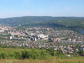
Mariinsk is a town in Kemerovo Oblast, Russia, where the Trans-Siberian Railway crosses the Kiya River, 180 kilometers (110 mi) northeast of Kemerovo, the administrative center of the oblast. Population: 40,526 (2010 Census); 42,977 (2002 Census); 40,956 (1989 Census); 39,700 (1972).

Anzhero-Sudzhensk is a town in the Kuznetsk Basin in Kemerovo Oblast, Russia, located to the north of the oblast's administrative center of Kemerovo and to the east of the Tom River, on the route of the Trans-Siberian Railway. Population: 76,646 (2010 Census); 86,480 (2002 Census); 107,951 (1989 Census).

Kiselyovsk is a town in Kemerovo Oblast, Russia, located in the foothill belt of the Salair Ridge, at the source of the Aba River, 193 kilometers (120 mi) south of Kemerovo. Population: 98,365 (2010 Census); 106,341 (2002 Census); 128,083 (1989 Census).
Mezhdurechensk is a city in Kemerovo Oblast, Russia. Population: 101,678 (2010 Census); 101,987 (2002 Census); 107,014 (1989 Census).
Yurga is a town in Kemerovo Oblast, Russia, located on the Tom River. Population: 81,533 (2010 Census); 85,555 (2002 Census); 93,202 (1989 Census).

Guryevsk is a town in Kemerovo Oblast, Russia, located 195 kilometers (121 mi) southeast of Kemerovo, the administrative center of the oblast. Population: 24,817 (2010 Census); 27,381 (2002 Census); 28,152 (1989 Census).

Beryozovsky is a town in Kemerovo Oblast, Russia, located between the Barzas and Shurap Rivers, 27 kilometers (17 mi) north of Kemerovo, the administrative center of the oblast. Population: 47,279 (2010 Census); 48,299 (2002 Census); 51,250 (1989 Census).

Kaltan is a town in Kemerovo Oblast, Russia, located on the Kondoma River, 338 kilometers (210 mi) south of Kemerovo, the administrative center of the oblast. Population: 21,892 (2010 Census); 25,591 (2002 Census); 25,369 (1989 Census).

Leninsk-Kuznetsky District is an administrative district (raion), one of the nineteen in Kemerovo Oblast, Russia. As a municipal division, it is incorporated as Leninsk-Kuznetsky Municipal District. It is located in the west of the oblast. The area of the district is 2,356 square kilometers (910 sq mi). Its administrative center is the city of Leninsk-Kuznetsky. Population: 23,760 (2010 Census); 27,825 ; 29,752 (1989 Census).

Mezhdurechensky District is an administrative district (raion), one of the nineteen in Kemerovo Oblast, Russia. It is located in the southeast of the oblast. Its administrative center is the city of Mezhdurechensk. Population: 2,268 (2010 Census); 2,658.

Novokuznetsky District is an administrative district (raion), one of the nineteen in Kemerovo Oblast, Russia. As a municipal division, it is incorporated as Novokuznetsky Municipal District. It is located in the center of the oblast and spans it from border to border in the southwest-northeast direction. The area of the district is 13,039.5989 square kilometers (5,034.6173 sq mi). Its administrative center is the city of Novokuznetsk. As of the 2010 Census, the total population of the district was 50,681.

Prokopyevsky District is an administrative district (raion), one of the nineteen in Kemerovo Oblast, Russia. As a municipal division, it is incorporated as Prokopyevsky Municipal District. It is located in the center of the oblast. The area of the district is 3,450 square kilometers (1,330 sq mi). Its administrative center is the city of Prokopyevsk. Population: 31,442 (2010 Census); 33,705 ; 35,657 (1989 Census).
Promyshlennovsky District is an administrative district (raion), one of the nineteen in Kemerovo Oblast, Russia. As a municipal division, it is incorporated as Promyshlennovsky Municipal District. It is located in the west of the oblast. The area of the district is 3,083 square kilometers (1,190 sq mi). Its administrative center is the urban locality of Promyshlennaya. Population: 50,106 (2010 Census); 50,125 ; 47,150 (1989 Census). The population of Promyshlennaya accounts for 36.0% of the district's total population.

Tashtagolsky District is an administrative district (raion), one of the nineteen in Kemerovo Oblast, Russia. As a municipal division, it is incorporated as Tashtagolsky Municipal District. It is located in the south of the oblast. The area of the district is 11,383 square kilometers (4,395 sq mi). Its administrative center is the town of Tashtagol. Population: 31,895 (2010 Census); 34,545 ; 37,816 (1989 Census).
Tisulsky District is an administrative district (raion), one of the nineteen in Kemerovo Oblast, Russia. As a municipal division, it is incorporated as Tisulsky Municipal District. It is located in the east of the oblast. The area of the district is 8,100 square kilometers (3,100 sq mi). Its administrative center is the urban locality of Tisul. Population: 25,045 (2010 Census); 28,471 ; 34,707 (1989 Census). The population of Tisul accounts for 36.1% of the district's total population.
Tyazhinsky District is an administrative district (raion), one of the nineteen in Kemerovo Oblast, Russia. As a municipal division, it is incorporated as Tyazhinsky Municipal District. It is located in the northeast of the oblast. The area of the district is 3,531 square kilometers (1,363 sq mi). Its administrative center is the urban locality of Tyazhinsky. Population: 25,597 (2010 Census); 32,782 ; 32,574 (1989 Census). The population of the administrative center accounts for 43.4% of the district's total population.

Yaysky District is an administrative district (raion), one of the nineteen in Kemerovo Oblast, Russia. As a municipal division, it is incorporated as Yaysky Municipal District. It is located in the north of the oblast. The area of the district is 2,669 square kilometers (1,031 sq mi). Its administrative center is the urban locality of Yaya. Population: 20,383 (2010 Census); 24,982 ; 26,759 (1989 Census). The population of Yaya accounts for 57.3% of the district's total population.

Yurginsky District is an administrative district (raion), one of the nineteen in Kemerovo Oblast, Russia. As a municipal division, it is incorporated as Yurginsky Municipal District. It is located in the northwest of the oblast. The area of the district is 2,510 square kilometers (970 sq mi). Its administrative center is the town of Yurga. Population: 22,448 (2010 Census); 22,779 ; 22,994 (1989 Census).

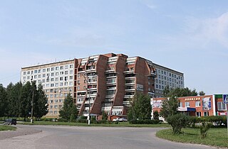
Krasnobrodsky is an urban locality in Kemerovo Oblast, Russia. Population: 11,919 (2010 Census); 11,859 (2002 Census); 12,663 (1989 Census).