
Prokopyevsk is a city in Kemerovo Oblast, Russia. Population: 210,130 (2010 Census); 224,597 (2002 Census); 273,838 (1989 Census).

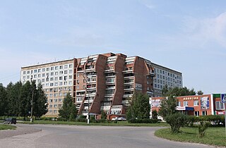
Kiselyovsk is a town in Kemerovo Oblast, Russia, located in the foothill belt of the Salair Ridge, at the source of the Aba River, 193 kilometers (120 mi) south of Kemerovo. Population: 98,365 (2010 Census); 106,341 (2002 Census); 128,083 (1989 Census).
Yurga is a town in Kemerovo Oblast, Russia, located on the Tom River and the Trans-Siberian Railway. Population: 81,533 (2010 Census); 85,555 (2002 Census); 93,202 (1989 Census).

Salair is a town administratively subordinated to Guryevsk Town Under Oblast Jurisdiction in Kemerovo Oblast, Russia, located 210 kilometers (130 mi) south of Kemerovo, the administrative center of the oblast. Population: 8,262 (2010 Census); 9,472 (2002 Census); 11,452 (1989 Census).

Guryevsk is a town in Kemerovo Oblast, Russia, located 195 kilometers (121 mi) southeast of Kemerovo, the administrative center of the oblast. Population: 24,817 (2010 Census); 27,381 (2002 Census); 28,152 (1989 Census).

Topki is a town in Kemerovo Oblast, Russia, located 38 kilometers (24 mi) west of Kemerovo, the administrative center of the oblast. Population: 28,641 (2010 Census); 31,004 (2002 Census); 33,574 (1989 Census).

Kaltan is a town in Kemerovo Oblast, Russia, located on the Kondoma River, 338 kilometers (210 mi) south of Kemerovo, the administrative center of the oblast. Population: 21,892 (2010 Census); 25,591 (2002 Census); 25,369 (1989 Census).

Belovsky District is an administrative district (raion), one of the nineteen in Kemerovo Oblast, Russia. As a municipal division, it is incorporated as Belovsky Municipal District. It is located in the center of the oblast. The area of the district is 3,400 square kilometers (1,300 sq mi). Its administrative center is the rural locality of Vishnevka. Population: 30,204 (2010 Census); 33,382 ; 25,815 (1989 Census).

Chebulinsky District is an administrative district (raion), one of the nineteen in Kemerovo Oblast, Russia. As a municipal division, it is incorporated as Chebulinsky Municipal District. It is located in the north of the oblast. The area of the district is 3,780 square kilometers (1,460 sq mi). Its administrative center is the urban locality of Verkh-Chebula. Population: 16,348 (2010 Census); 17,971 ; 17,723 (1989 Census). The population of Verkh-Chebula accounts for 31.0% of the district's total population.

Izhmorsky District is an administrative district (raion), one of the nineteen in Kemerovo Oblast, Russia. As a municipal division, it is incorporated as Izhmorsky Municipal District. It is located in the north of the oblast. The area of the district is 3,580 square kilometers (1,380 sq mi). Its administrative center is the urban locality of Izhmorsky. Population: 13,517 (2010 Census); 16,476 ; 19,025 (1989 Census). The population of the administrative center accounts for 41.5% of the district's total population.

Krapivinsky District is an administrative district (raion), one of the nineteen in Kemerovo Oblast, Russia. As a municipal division, it is incorporated as Krapivinsky Municipal District. It is located in the center of the oblast. The area of the district is 6,900 square kilometers (2,700 sq mi). Its administrative center is the urban locality of Krapivinsky. Population: 24,533 (2010 Census); 27,658 ; 31,357 (1989 Census). The population of the administrative center accounts for 30.4% of the district's total population.

Leninsk-Kuznetsky District is an administrative district (raion), one of the nineteen in Kemerovo Oblast, Russia. As a municipal division, it is incorporated as Leninsk-Kuznetsky Municipal District. It is located in the west of the oblast. The area of the district is 2,356 square kilometers (910 sq mi). Its administrative center is the city of Leninsk-Kuznetsky. Population: 23,760 (2010 Census); 27,825 ; 29,752 (1989 Census).

Mariinsky District is an administrative district (raion), one of the nineteen in Kemerovo Oblast, Russia. As a municipal division, it is incorporated as Mariinsky Municipal District. It is located in the north of the oblast. The area of the district is 5,607 square kilometers (2,165 sq mi). Its administrative center is the town of Mariinsk. Population: 17,285 (2010 Census); 19,182 ; 22,037 (1989 Census).

Mezhdurechensky District is an administrative district (raion), one of the nineteen in Kemerovo Oblast, Russia. It is located in the southeast of the oblast. Its administrative center is the city of Mezhdurechensk. Population: 2,268 (2010 Census); 2,658.
Promyshlennovsky District is an administrative district (raion), one of the nineteen in Kemerovo Oblast, Russia. As a municipal division, it is incorporated as Promyshlennovsky Municipal District. It is located in the west of the oblast. The area of the district is 3,083 square kilometers (1,190 sq mi). Its administrative center is the urban locality of Promyshlennaya. Population: 50,106 (2010 Census); 50,125 ; 47,150 (1989 Census). The population of Promyshlennaya accounts for 36.0% of the district's total population.

Tashtagolsky District is an administrative district (raion), one of the nineteen in Kemerovo Oblast, Russia. As a municipal division, it is incorporated as Tashtagolsky Municipal District. It is located in the south of the oblast. The area of the district is 11,383 square kilometers (4,395 sq mi). Its administrative center is the town of Tashtagol. Population: 31,895 (2010 Census); 34,545 ; 37,816 (1989 Census).

Topkinsky District is an administrative district (raion), one of the nineteen in Kemerovo Oblast, Russia. As a municipal division, it is incorporated as Topkinsky Municipal District. It is located in the northwest of the oblast. The area of the district is 2,774 square kilometers (1,071 sq mi). Its administrative center is the town of Topki. Population: 16,246 (2010 Census); 18,077 ; 19,018 (1989 Census).

Yaysky District is an administrative district (raion), one of the nineteen in Kemerovo Oblast, Russia. As a municipal division, it is incorporated as Yaysky Municipal District. It is located in the north of the oblast. The area of the district is 2,669 square kilometers (1,031 sq mi). Its administrative center is the urban locality of Yaya. Population: 20,383 (2010 Census); 24,982 ; 26,759 (1989 Census). The population of Yaya accounts for 57.3% of the district's total population.

Yurginsky District is an administrative district (raion), one of the nineteen in Kemerovo Oblast, Russia. As a municipal division, it is incorporated as Yurginsky Municipal District. It is located in the northwest of the oblast. The area of the district is 2,510 square kilometers (970 sq mi). Its administrative center is the town of Yurga. Population: 22,448 (2010 Census); 22,779 ; 22,994 (1989 Census).

Polysayevo is a town in Kemerovo Oblast, Russia, located on the right bank of the Inya River 139 kilometers (86 mi) south of Kemerovo. Population: 27,624 (2010 Census); 28,151 (2002 Census).


