
West Yorkshire is a metropolitan and ceremonial county in the Yorkshire and the Humber region of England. It borders North Yorkshire to the north and east, South Yorkshire and Derbyshire to the south, Greater Manchester to the south-west, and Lancashire to the west. The city of Leeds is the largest settlement.

Brighouse is a town within the metropolitan borough of Calderdale, in West Yorkshire, England. Historically within the West Riding of Yorkshire, it is situated on the River Calder, 4 miles (6.4 km) east of Halifax. It is served by Junction 25 of the M62 motorway and Brighouse railway station on the Caldervale Line and Huddersfield Line. In the town centre is a mooring basin on the Calder and Hebble Navigation. The United Kingdom Census 2001 gave the Brighouse / Rastrick subdivision of the West Yorkshire Urban Area a population of 32,360. The Brighouse ward of Calderdale Council gave a population of 11,195 at the 2011 Census. Brighouse has a HD6 postcode.

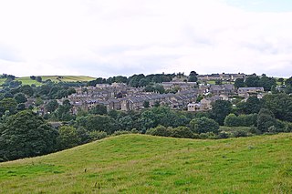
Mytholmroyd is a large village and former civil parish, now in the parish of Hebden Royd, in the Calderdale district, in West Yorkshire, England, 2 miles (3 km) east of Hebden Bridge. It lies in the Upper Calder Valley, 10 miles (16 km) east of Burnley and 7 miles (11 km) west of Halifax. The village, which has a population of approximately 4,000, is in the Luddendenfoot Ward of Calderdale Council.
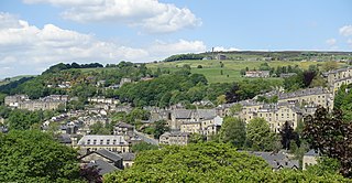
Hebden Bridge is a market town in the Calderdale district of West Yorkshire, England. It is in the Upper Calder Valley, 8 miles (13 km) west of Halifax and 14 miles (21 km) north-east of Rochdale, at the confluence of the River Calder and the Hebden Water. The town is the largest settlement in the civil parish of Hebden Royd.

Sowerby Bridge is a market town in the Upper Calder Valley in Calderdale in West Yorkshire, England. The Calderdale Council ward population at the 2011 census was 11,703.

Calderdale is a metropolitan borough of West Yorkshire, England, which had a population of 211,439. It takes its name from the River Calder, and dale, a word for valley. The name Calderdale usually refers to the borough through which the upper river flows, while the actual landform is known as the Calder Valley. Several small valleys contain tributaries of the River Calder. The main towns of the borough are Brighouse, Elland, Halifax, Hebden Bridge, Sowerby Bridge and Todmorden.

Halifax is a constituency represented in the House of Commons of the UK Parliament since 2015 by Holly Lynch of the Labour Party.

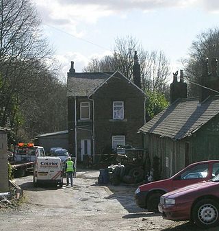
Luddenden is a district of Calderdale 3.1 miles (5 km) west of Halifax on the Luddenden Brook in the county of West Yorkshire, England.

Hebble Brook is a river passing south from Ogden Reservoir, at Ogden, through Halifax and empties into the River Calder at Salterhebble.
Skircoat Green is an area to the south of Halifax, West Yorkshire, England. Skircoat is a ward of the Borough of Calderdale whose population at the 2011 Census was 12,712.
King Cross, originally the site of an ancient stone cross, is an ecclesiastical parish created in 1845 in the Metropolitan Borough of Calderdale, West Yorkshire, England. Part of the Diocese of Wakefield, it is located along the top of a ridge above the town of Halifax. The A58 road into Lancashire divides here, with one fork, the A646, branching off towards Burnley via Hebden Bridge and the other going to Littleborough via Sowerby Bridge. During the English Civil War, when Halifax was a Royalist stronghold, King Cross was a key outpost, with the Parliamentarians holding parts of the Calder Valley.
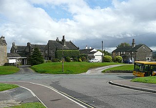
Hipperholme is a village in West Yorkshire, England, located between the towns of Halifax and Brighouse in the Hipperholme and Lightcliffe ward of the Metropolitan Borough of Calderdale. The population of this ward at the 2011 Census was 11,308.
Ogden in West Yorkshire, England, is a small hamlet 5.0 miles (8 km) north of Halifax. The hamlet falls within the Calderdale Ward of Illingworth and Mixenden. Its most recognisable landmarks are Ovenden Moor wind farm, which can be seen from as far as 35 miles (56 km) away on a clear day, a golf course, which offers views of the surrounding moorland; and Ogden reservoir, around which are footpaths for visitors to walk and view the local wildlife.
Ovenden is a village in West Yorkshire, England, next to Boothtown and Illingworth about a mile from Halifax town centre. It is also a Calderdale Ward whose population at the 2011 Census was 12,351.

Halifax is a town in the Metropolitan Borough of Calderdale, in West Yorkshire, England. It is near the east Pennine foothills. In the 15th century, the town became an economic hub of the old West Riding of Yorkshire, primarily in woollen manufacture with the large Piece Hall square later built for trading wool in the town centre. The town was a thriving mill town during the Industrial Revolution with the Dean Clough Mill buildings a surviving landmark. In 2011, it had a population of 88,134. It is also the administrative centre of the wider Calderdale Metropolitan Borough.

Scouting in Yorkshire and the Humber is largely represented by the Scout Association of the United Kingdom and some Groups of traditional Scouting including the Baden-Powell Scouts' Association.
Holywell Green is a village in the civil parish of Stainland and District, in the Calderdale, district, in the county of West Yorkshire, England. The village is situated approximately 1.4 miles (2 km) south-west of Elland, 3.3 miles (5 km) south of Halifax and 3.9 miles (6 km) north-west of Huddersfield. Holywell Green is part of the Greetland and Stainland Ward of Calderdale Council.

Illingworth is a village within the Metropolitan Borough of Calderdale, in West Yorkshire, England. The appropriate Calderdale Ward is called Illingworth and Mixenden. The population of this ward at the 2011 Census was 12,739. It is situated 3.3 miles (5.3 km) north-west of Halifax.

West Vale is a village in Calderdale, West Yorkshire, England. The village falls within the Greetland and Stainland parish of the Calderdale Council. It is 2.5 miles (4.0 km) south of Halifax, 2 miles (3.2 km) west of Elland and 4 miles (6.4 km) north-west of Huddersfield.
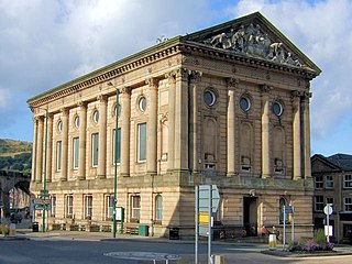
Todmorden Town Hall is a municipal building in Halifax Road, Todmorden, West Yorkshire, England. The town hall, which is the meeting place of Todmorden Town Council, is a grade I listed building.


