
Lardal is a former municipality in Vestfold county, Norway. The 278-square-kilometre (107 sq mi) municipality existed from 1838 until its dissolution in 2018. The area is now part of Larvik Municipality. The administrative centre was the village of Svarstad. The village of Steinsholt was also part of Lardal.

Hjartdal is a municipality in Telemark county, Norway. It is located in the traditional district of Upper Telemark and Aust-Telemark. The administrative centre of the municipality is the village of Sauland. Other villages in the municipality include Tuddal and Hjartdalsbygda.
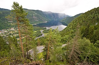
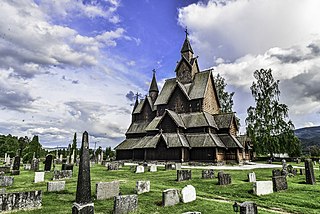
Tokke is a municipality in Telemark county, Norway. It is located in the traditional district of Vest-Telemark. The administrative centre of the municipality is the village of Dalen. Other villages in Tokke include Åmdals Verk, Eidsborg, Høydalsmo, Lårdal, and Øvre Byrte. The Eidsborg Stave Church is one of Norway's old stave churches and it is located in Eidsborg, just north of Dalen.
Kviteseid is a municipality in Telemark county, Norway. It is located in the traditional districts of Vest-Telemark and Upper Telemark. The administrative centre of the municipality is the village of Kviteseidbyen. Other villages in Kviteseid include Åsgrend, Brunkeberg, Eidstod, Fjågesund, Kilen, Morgedal, and Vrådal.

Vinje is a municipality in Telemark county, Norway. It is located in the traditional district of Vest-Telemark which is part of Øvre Telemark. The administrative centre of the municipality is the village of Åmot. Other villages in the municipality include Arabygdi, Edland, Grunge, Haukeli, Krossen, Møsstrond, Nesland, Øyfjell, Raulandsgrend, and Vinje.

Sauherad is a former municipality in Telemark county, Norway. It was part of the traditional region of Midt-Telemark. The 321-square-kilometre (124 sq mi) municipality existed from 1838 until its dissolution in 2020. The area is now part of Midt-Telemark Municipality and Notodden Municipality. The administrative centre was the village of Akkerhaugen. Other villages in the municipality included Gvarv, Holtsås, Hjukse, Hjuksebø, Nordagutu, and Sauherad. Sauherad bordered the municipalities of Kongsberg, Skien, Nome, Bø, and Notodden.
Bø is a former municipality in Telemark county, Norway. It was part of the traditional region of Midt-Telemark, but was historically regarded as part of Grenland. The 263-square-kilometre (102 sq mi) municipality existed from 1838 until its dissolution in 2020. The area is now part of Midt-Telemark Municipality. The administrative centre was the village of Bø i Telemark. Other villages in the municipality included Folkestad and Nordbøåsane.
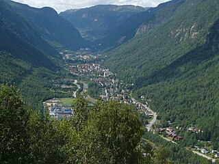
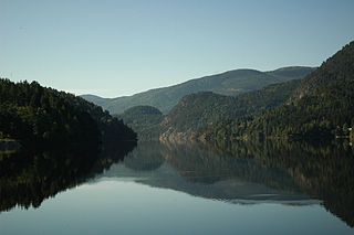
Tinn is a municipality in Telemark county, Norway. It is located in the traditional districts of Aust-Telemark and Upper Telemark. The administrative centre of the municipality is the town of Rjukan. Some of the villages in Tinn include Atrå, Austbygde, Hovin, and Miland.

Tustna is a former municipality in Møre og Romsdal county, Norway. The administrative centre was the village of Gullstein. The municipality is located in the present-day Aure Municipality. The municipality included the main islands of Tustna, Stabblandet, and Solskjelsøya, as well as many smaller, surrounding islets between the Edøyfjorden and the Vinjefjorden. In 2006, when the municipality was merged into Aure, it was 141 square kilometres (54 sq mi).
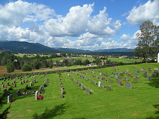
Heddal is a former municipality in Telemark county, Norway. The 407-square-kilometre (157 sq mi) municipality existed from 1838 until its dissolution in 1964. The area is now part of Notodden Municipality. The administrative centre was the village of Heddal where the Heddal Stave Church.

Eidanger is a former municipality in Telemark county, Norway. The 136-square-kilometre (53 sq mi) municipality existed from 1838 until its dissolution in 1964. The area is now part of Porsgrunn Municipality. The administrative centre was the village of Eidanger where Eidanger Church is located.
Gransherad is a former municipality in Telemark county, Norway. The 417-square-kilometre (161 sq mi) municipality existed from 1860 until its dissolution in 1964. The area is now part of Notodden Municipality and Kongsberg Municipality. The administrative centre was the village of Gransherad where Gransherad Church is located.

Lunde is a former municipality in Telemark county, Norway. The 275-square-kilometre (106 sq mi) municipality existed from 1867 until its dissolution in 1964. The area is now part of Nome Municipality. It was part of the traditional district of Midt-Telemark. The administrative centre was the village of Bjervamoen.

Rauland is a former municipality in Telemark county, Norway. The 1,830-square-kilometre (710 sq mi) municipality existed from 1860 until its dissolution in 1964. The area is now part of Vinje Municipality. The administrative centre was the village of Raulandsgrend which is where Rauland Church is located. The municipality was a very mountainous, rural area, with about 90% of its area at elevations of 900 metres (3,000 ft) above sea level or higher.

Hovin is a former municipality in Telemark county, Norway. The 302.5-square-kilometre (116.8 sq mi) municipality existed from 1886 until its dissolution in 1964. The area is now divided between Tinn Municipality and Notodden Municipality. The administrative centre was the village of Hovin. The other main village in the municipality was Rudsgrendi on the opposite side of the lake Tinnsjå.

Solum is a former municipality in Telemark county, Norway. The 318-square-kilometre (123 sq mi) municipality existed from 1838 until its dissolution in 1964. The area is now part of Skien Municipality. The administrative centre was the village of Solum, just south of Klovholt. Solum Church was the main church for the municipality.

Åsen is a former municipality in the old Nord-Trøndelag county, Norway. The 140-square-kilometre (54 sq mi) municipality existed from 1838 until its dissolution in 1962. The municipality was located to the southwest part of what is now Levanger municipality in Trøndelag county, roughly bordered in the north by the lakes Hammervatnet and Hoklingen, and by the Åsenfjorden to the west. The administrative centre was the village of Åsen.

Kolbu is a former municipality in the old Oppland county, Norway. The 132-square-kilometre (51 sq mi) municipality existed from 1908 until its dissolution in 1964. The area is now part of Østre Toten Municipality in the traditional district of Toten. The administrative centre was the village of Kolbu.
Eina is a former municipality in the old Oppland county, Norway. The 104-square-kilometre (40 sq mi) municipality existed from 1908 until its dissolution in 1964. The area is now part of Vestre Toten Municipality in the traditional district of Toten. The administrative centre was the village of Eina.

Lårdal is a former municipality in Telemark county, Norway. The 288-square-kilometre (111 sq mi) municipality existed from 1838 until its dissolution in 1964. The area centered around the Lårdalen valley and it is now part of Tokke Municipality. The administrative centre was the village of Lårdal.


