[[East Siberian System]]"},"location":{"wt":"[[Sakha Republic]],[[Far Eastern Federal District]]"},"map":{"wt":"Russia Sakha Republic"},"map_caption":{"wt":"Location in the [[Sakha Republic]],Russia"},"label_position":{"wt":""},"range_coordinates":{"wt":"{{coord|66|35|34|N|144|46|29|E|region:RU_type:mountain|format=dms|display=inline,title}}"},"range_coordinates_note":{"wt":""},"geology":{"wt":""},"period":{"wt":""},"orogeny":{"wt":""},"length_km":{"wt":"470"},"length_orientation":{"wt":"NW / SE"},"width_km":{"wt":""},"width_orientation":{"wt":""},"easiest_route":{"wt":"From [[Khonuu]]"}},"i":0}}]}" id="mwBA">.mw-parser-output .infobox-subbox{padding:0;border:none;margin:-3px;width:auto;min-width:100%;font-size:100%;clear:none;float:none;background-color:transparent}.mw-parser-output .infobox-3cols-child{margin:auto}.mw-parser-output .infobox .navbar{font-size:100%}body.skin-minerva .mw-parser-output .infobox-header,body.skin-minerva .mw-parser-output .infobox-subheader,body.skin-minerva .mw-parser-output .infobox-above,body.skin-minerva .mw-parser-output .infobox-title,body.skin-minerva .mw-parser-output .infobox-image,body.skin-minerva .mw-parser-output .infobox-full-data,body.skin-minerva .mw-parser-output .infobox-below{text-align:center}@media screen{html.skin-theme-clientpref-night .mw-parser-output .infobox-full-data:not(.notheme)>div:not(.notheme)[style]{background:#1f1f23!important;color:#f8f9fa}}@media screen and (prefers-color-scheme:dark){html.skin-theme-clientpref-os .mw-parser-output .infobox-full-data:not(.notheme) div:not(.notheme){background:#1f1f23!important;color:#f8f9fa}}@media(min-width:640px){body.skin--responsive .mw-parser-output .infobox-table{display:table!important}body.skin--responsive .mw-parser-output .infobox-table>caption{display:table-caption!important}body.skin--responsive .mw-parser-output .infobox-table>tbody{display:table-row-group}body.skin--responsive .mw-parser-output .infobox-table tr{display:table-row!important}body.skin--responsive .mw-parser-output .infobox-table th,body.skin--responsive .mw-parser-output .infobox-table td{padding-left:inherit;padding-right:inherit}}
Moma Range | |
---|---|
Момский хребет / Муома сиһэ | |
Location in the Sakha Republic, Russia | |
Highest point | |
Peak | Unnamed |
Elevation | 2,533 m (8,310 ft) |
Dimensions | |
Length | 470 km (290 mi)NW / SE |
Geography | |
Location | Sakha Republic, Far Eastern Federal District |
Range coordinates | 66°35′34″N144°46′29″E / 66.59278°N 144.77472°E |
Parent range | Momsko-Chersk Region, East Siberian System |
Climbing | |
Easiest route | From Khonuu |
The Moma Range (Russian : Момский хребет, Momsky Khrebet; Yakut : Муома сиһэ) is a range of mountains in far North-eastern Russia. Administratively the range is part of the Sakha Republic of the Russian Federation. [1] The nearest town is Khonuu, served by Moma Airport.
The name originated in the Evenki language, where "мома" means wood, timber or tree.
The Moma Range extends from NW to SE for almost 500 kilometres (310 mi) southeast of the southern end of the Selennyakh Range and north of the Ulakhan-Chistay Range, the highest subrange of the Chersky Range system. It is parallel to the latter and separated from it by a wide intermontane basin, where the Moma River flows from the southeast and joins the Indigirka. Turning northwards, the Indigirka River cuts deeply across the range in its northwestern part. The Aby Lowland, part of the Yana-Indigirka Lowland, lies to the north and the Alazeya Plateau to the east. [2]
The highest point of the Moma Range is an unnamed 2,533 metres (8,310 ft) high peak located very near the Arctic Circle. Rivers Badyarikha, a tributary of the Indigirka, and Ozhogina, a tributary of the Kolyma, flow from the northern slopes of the Moma Range. [1]
In some works the Moma Range is included in the Chersky mountain system. [3]
The Chersky Range is a chain of mountains in northeastern Siberia between the Yana and Indigirka Rivers. Administratively, the area of the range belongs to the Sakha Republic, although a small section in the east is within Magadan Oblast. The highest peak in the range is the 3,003-metre (9,852 ft)-tall Peak Pobeda, part of the Ulakhan-Chistay Range. The range also includes important places of traditional Yakut culture, such as Ynnakh Mountain (Mat'-Gora) and kigilyakh rock formations.
Lake Ozhogino is a large shallow freshwater lake in Sakha, Russia. It has an area of 157 km². It freezes up in late September and stays icebound until June. Ozhogin River flows from the lake.
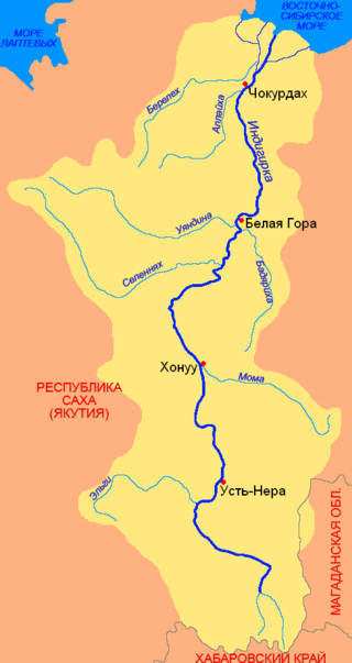
The Moma is a river in Yakutia in Russia, a right tributary of the Indigirka. The length of the river is 406 kilometres (252 mi), the area of its drainage basin is 30,200 square kilometres (11,700 sq mi).
The Badyarikha is a river in Yakutia in Russia, a right tributary of the Indigirka. The length of the Badyarikha is 545 kilometres (339 mi) and the area of its drainage basin is 12,200 square kilometres (4,700 sq mi). Its sources are located on the northern slopes of the Moma Range
The Ozhogina is a tributary of the Kolyma in eastern Siberia. The river is 523 kilometres (325 mi) long. The area of its basin is 24,300 square kilometres (9,400 sq mi).
The Selennyakh is a river in Sakha Republic, Russia. It is a left tributary of the Indigirka.
The Anadyr Highlands are a mountainous area in the Chukotka Autonomous Okrug, Far Eastern Federal District, Russia.
The Polousny Range is a mountain range in the Sakha Republic, Far Eastern Federal District, Russia.
The Aby Lowland is a low alluvial plain located in the Sakha Republic, Far Eastern Federal District, Russia. Administratively most of the territory of the lowland is part of Aby District (Aby Ulus).
Suturuokha is a freshwater lake in the Sakha Republic, Russia. It lies in the middle course area of the Indigirka River, to the west of it. Administratively the lake is part of Aby District (Aby Ulus).
The Ulakhan-Sis Range is a mountain range in the Sakha Republic, Far Eastern Federal District, Russia.
The Kular Range is a range of mountains in far North-eastern Russia. Administratively the range is part of the Eveno-Bytantaysky National District of the Sakha Republic, Russian Federation.
The Ulakhan-Chistay Range is a range of mountains in far North-eastern Russia. Administratively the range is part of the Sakha Republic of the Russian Federation.
The Byoryolyokh is a river in Yakutia in Russia. It flows into the Russko-Ustyinskaya, a left distributary of the Indigirka.
The Yana-Indigirka Lowland is a large, low alluvial plain located in northern Siberia, Far Eastern Federal District, Russia.
The Selennyakh Range is a range of mountains in far North-eastern Russia. Administratively the range is part of the Sakha Republic of the Russian Federation. The town of Deputatsky, capital of the Ust-Yansky District, is located in the area of the range.
The East Siberian Lowland, also known as Yana-Kolyma Lowland, is a vast plain in North-eastern Siberia, Russia. The territory of the lowland is one of the Great Russian Regions. Administratively, it is a part of the Sakha Republic (Yakutia).
The Arga-Tas is a mountain range in far North-eastern Russia. Administratively it is part of the Sakha Republic (Yakutia), Russian Federation. The range extends along the southwestern part of the Upper Kolyma District. The village of Utaya, administrative center of the Utainsky Rural Okrug is located at the feet of the range.
Kropotkin Range is a mountain range in Okinsky District, Buryatia, Russian Federation.
The Kelter Range is a range of mountains in far North-eastern Russia. Administratively the range is part of the Sakha Republic, Russian Federation.