Monroe, Arkansas | |
---|---|
Coordinates: 34°44′03″N91°06′24″W / 34.73417°N 91.10667°W | |
Country | United States |
State | Arkansas |
Counties | Lee and Monroe |
Area | |
• Total | 0.73 sq mi (1.9 km2) |
• Land | 0.73 sq mi (1.9 km2) |
• Water | 0.0 sq mi (0 km2) |
Elevation | 190 ft (60 m) |
Population (2020) [3] | |
• Total | 51 |
Time zone | UTC-6 (Central (CST)) |
• Summer (DST) | UTC-5 (CDT) |
ZIP code | 72108 |
Area code | 870 |
GNIS feature ID | 2805661 [2] |
FIPS code | 05-46460 |
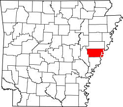
Monroe is an unincorporated community and census-designated place (CDP) in Monroe County, Arkansas, United States. The unincorporated community extends beyond the CDP slightly into Lee County. It was first listed as a CDP in the 2020 census with a population of 51. [3]
Monroe is located at the junction of U.S. Route 79 and Arkansas Highway 39, 12 miles (19 km) east-northeast of Clarendon. Monroe has a post office with ZIP code 72108. [4]
Census | Pop. | Note | %± |
---|---|---|---|
2020 | 51 | — | |
U.S. Decennial Census [5] 2020 [6] |
Race / Ethnicity (NH = Non-Hispanic) | Pop 2020 [6] | % 2020 |
---|---|---|
White alone (NH) | 36 | 70.59% |
Black or African American alone (NH) | 9 | 17.65% |
Native American or Alaska Native alone (NH) | 0 | 0.00% |
Asian alone (NH) | 0 | 0.00% |
Pacific Islander alone (NH) | 0 | 0.00% |
Some Other Race alone (NH) | 1 | 1.96% |
Mixed Race or Multi-Racial (NH) | 2 | 3.92% |
Hispanic or Latino (any race) | 3 | 5.88% |
Total | 51 | 100.00% |
Genoa is an unincorporated community and census-designated place (CDP) in Miller County, Arkansas, United States. It was first listed as a CDP in the 2020 census with a population of 972. It is located 6 to 12 miles east of Texarkana along Highway 196. Although unincorporated, Genoa has a post office, with the ZIP code of 71840 for a specific post office box. Most of the community is served by ZIP code 71854 (Texarkana). Genoa also has its own school district, Genoa Central School District.
Ozone is an unincorporated community and census-designated place (CDP) in Johnson County, Arkansas, United States. Ozone is located on Arkansas Highway 21, 11.5 miles (18.5 km) north of Clarksville. It was first listed as a CDP in the 2020 census with a population of 92. Ozone has a post office with ZIP code 72854.
Pencil Bluff is an unincorporated community and census-designated place (CDP) in Montgomery County, Arkansas, United States. Pencil Bluff is located at the junction of U.S. Route 270 and Arkansas Highway 88, 7.5 miles (12.1 km) northwest of Mount Ida. It was first listed as a CDP in the 2020 census with a population of 72.
Drasco is an unincorporated community and census-designated place (CDP) in Cleburne County, Arkansas, United States, with a ZIP code of 72530. Drasco lies just northeast of Greers Ferry Lake and includes the lakeside community of Tannenbaum.
Centerville is an unincorporated community and census-designated place (CDP) in Yell County, Arkansas, United States. Centerville is located at the junction of Arkansas Highways 7 and 154, 6.5 miles (10.5 km) north-northeast of Ola. It was first listed as a CDP in the 2020 census with a population of 283.
Boles is an unincorporated community and census-designated place (CDP) in Scott County, Arkansas, United States. It was first listed as a CDP in the 2020 census with a population of 166.
Alix is an unincorporated community and census-designated place (CDP) in Franklin County, Arkansas, United States. Alix is located on Arkansas Highway 186, 1.5 miles (2.4 km) east of Denning. Alix has a post office with ZIP code 72820.
Board Camp is an unincorporated community and census-designated place (CDP) in Polk County, Arkansas, United States. Board Camp is located on Arkansas Highway 8, 8.5 miles (13.7 km) east-southeast of Mena. Board Camp has a post office with ZIP code 71932.
Newhope is an unincorporated community and census-designated place (CDP) in Pike County, Arkansas, United States. Newhope is located at the junction of U.S. Route 70 and Arkansas Highway 369, 8 miles (13 km) west of Daisy. Newhope has a post office with ZIP code 71959.
Wesley is an unincorporated community and census-designated place (CDP) in western Madison County, Arkansas, United States. Wesley is located at the junction of Arkansas highways 74 and 295, 13 miles (21 km) by road west-southwest of Huntsville. Wesley has a post office with ZIP code 72773. It was first listed as a CDP in the 2020 census with a population of 161.
Ponca is an unincorporated community and census-designated place (CDP) in Newton County, Arkansas, United States. Ponca is located on Arkansas Highway 43, 10 miles (16 km) west of Jasper. Ponca has a post office with ZIP code 72670.
Oakland is an unincorporated community and census-designated place (CDP) in northeastern Marion County, Arkansas, United States. Oakland, located on Arkansas Highway 202, is 20 miles (32 km) by road northwest of Mountain Home. Oakland has a post office with ZIP code 72661. The Oakland Campground on Bull Shoals Lake lies about three miles to the west at the end of Route 202. It was first listed as a CDP in the 2020 census, with a population of 72.
Walcott is an unincorporated community and census-designated place (CDP) in Greene County, Arkansas, United States. Walcott is located at the junction of Arkansas highways 141 and 168, 10 miles (16 km) west of Paragould. It was first listed as a CDP in the 2020 census with a population of 152.
Ivan is an unincorporated community and census-designated place (CDP) in Dallas County, Arkansas, United States. Ivan is located along U.S. Route 167, 7 miles (11 km) north of Fordyce. Ivan has a post office with ZIP code 71748. It was first listed as a CDP in the 2020 census with a population of 135.
Mellwood is an unincorporated community and census-designated place (CDP) in Phillips County, Arkansas, United States. Mellwood is located on Arkansas Highway 44, 8.5 miles (13.7 km) southwest of Elaine. Mellwood has a post office with ZIP code 72367. It was first listed as a CDP in the 2020 census with a population of 21.
Oneida is an unincorporated community and census-designated place (CDP) in Phillips County, Arkansas, United States. Oneida is located along Arkansas Highway 85, 3.5 miles (5.6 km) north-northeast of Lake View. Oneida has a post office with ZIP code 72369. It was first listed as a CDP in the 2020 census with a population of 13.
Goodwin is an unincorporated community and census-designated place (CDP) in St. Francis County, Arkansas, United States. It was first listed as a CDP in the 2020 census with a population of 113. Goodwin is located along U.S. Route 70, 5.5 miles (8.9 km) east-northeast of Wheatley. Goodwin has a post office with ZIP code 72340.
Desha is an unincorporated community and census-designated place (CDP) in Independence County, Arkansas, United States. It was first listed as a CDP in the 2020 census with a population of 715.
Violet Hill is an unincorporated community and census-designated place (CDP) in Izard County, Arkansas, United States. Violet Hill is located on Arkansas Highway 56, 4 miles (6.4 km) west-southwest of Franklin. Violet Hill has a post office with ZIP code 72584. It was first listed as a CDP in the 2020 census with a population of 36.
Pleasant Grove is an unincorporated community and census-designated place (CDP) in Stone County, Arkansas, United States. It was first listed as a CDP in the 2020 census with a population of 235. Pleasant Grove is located along Arkansas Highway 14, 12.5 miles (20.1 km) east-southeast of Mountain View. Pleasant Grove has a post office with ZIP code 72567.