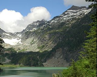
Kyes Peak, which is also known as "Goblin Peak", is a mountain peak located in the Henry M. Jackson Wilderness in Washington, United States. Kyes Peak rises to over 7,280 feet (2,220 m). Together with Columbia Peak and Monte Cristo Peak it forms a basin that contains Columbia Glacier and Blanca Lake. It is the highest summit in the Monte Cristo group of peaks.
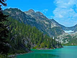
Columbia Peak is a mountain peak in the Henry M. Jackson Wilderness in the U.S. state of Washington. Columbia Peak rises to 7,172 feet (2,186 m). Together with Monte Cristo Peak and Kyes Peak it forms a basin that contains Columbia Glacier and Blanca Lake.

Sahale Mountain is a jagged, glaciated mountain, in North Cascades National Park, in northern Washington state. The summit of Sahale Mountain is referred to as Sahale Peak. It is 0.3 miles (0.48 km) south of its higher neighbor, Boston Peak, and the saddle between the two is 80 feet (24 m) lower than Sahale's summit. Quien Sabe Glacier is to the west of the ridge between the two peaks while Davenport Glacier is in a cirque east of this ridge and above Horseshoe Basin. Sahale Glacier is south of the summit and east of Sahale Arm, a ridge that extends southwest from Sahale to Cascade Pass. The name Sahale may originate from a Northwest Native American word meaning "high place," "falcon," or "sacred."

Buckner Mountain is a tall peak in the North Cascades of Washington state and in the Stephen Mather Wilderness of North Cascades National Park. At 9,114 feet (2,778 m) in elevation it is the highest in Skagit County and one of about ten of Washington's non-volcanic peaks above 9,000 feet high. It is ranked as the 14th highest peak in the state, and the third highest peak in North Cascades National Park.

Bacon Peak is a mountain located in North Cascades National Park, in the Cascade Range in the U.S. state of Washington. Its glaciers cover 1.2 square miles (3.2 km2); the three main glaciers are Diobsud Creek Glacier, Green Lake Glacier and Noisy Creek Glacier.
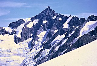
Forbidden Peak is an 8,815 feet (2,687 m) glacial horn located in North Cascades National Park, in Skagit County of Washington state. It is part of the North Cascades and is located near Cascade Pass. Forbidden Peak features a rock climbing route named West Ridge route which is featured in Fifty Classic Climbs of North America. The peak was first climbed by a party consisting of Fred Beckey, his brother Helmy Beckey, Jim Crooks, Lloyd Anderson and Dave Lind in 1940.

Klawatti Peak is located in North Cascades National Park in the U.S. state of Washington. Klawatti Peak is a nunatak, a peak surrounded by glaciers. These are Klawatti Glacier to the east, McAllister Glacier to the northwest and Inspiration Glacier to the south.

Sinister Peak is in Mount Baker-Snoqualmie and Wenatchee National Forests in the U.S. state of Washington. It is situated in Glacier Peak Wilderness and the North Cascades. Not quite 1 mi (1.6 km) east of Dome Peak, Sinister Peak is along a high ridge connecting the two peaks. The Chickamin Glacier is on the north slopes of Sinister Peak while the Garden Glacier is just southeast. Though some of the routes to the summit are technical, it can be reached by a moderate scramble.

Neve Peak is in North Cascades National Park in the U.S. state of Washington. Located in the south unit of the park, Neve Peak is .66 mi (1.06 km) west of Colonial Peak. The Neve Glacier is just south of Neve Peak while the Colonial Glacier descends from the north slopes of the mountain.

Stillaguamish Peak is a 5,720+ ft mountain summit near the western edge of the North Cascades, in Snohomish County of Washington state. It is located five miles north-northwest of Barlow Pass near the Monte Cristo area, and is situated on land administered by the Mount Baker-Snoqualmie National Forest. It rises 4,000 feet (1,200 m) above the Stillaguamish River and the Mountain Loop Highway.

Del Campo Peak is a prominent summit near the western edge of the North Cascades, in Snohomish County of Washington state. It is located south of Barlow Pass along the Mountain Loop Highway near the Monte Cristo area. It is situated on land administered by the Mount Baker-Snoqualmie National Forest. The mountain is named for a mining claim on the mountain's slope. The nearest peak is Gothic Peak, 0.5 miles (0.80 km) to the southwest, and Foggy Pass is the low point between the two peaks. Foggy Lake lies in Gothic Basin below the south face of Del Campo Peak and collects precipitation runoff which ultimately drains to South Fork Sauk River via Weden Creek. Runoff from the west side of the mountain drains into the Sultan River, and the north side drains into headwaters of the Stillaguamish River. In terms of favorable weather, the best months for climbing are July through September.

Mount Misch is a remote 7,435 ft mountain summit in the North Cascades, in Skagit County of Washington state. It is the highest point of the Buckindy Range, or Buckindy Ridge. It is located 19 miles east-northeast of Darrington, Washington, and 15 miles north-northwest of Glacier Peak which is one of the Cascade stratovolcanoes. It is situated in the Glacier Peak Wilderness on land administered by the Mount Baker-Snoqualmie National Forest. Mount Misch was named by mountaineer and author Fred Beckey for his friend Peter Misch (1909-1987), University of Washington geology professor and mountaineer, who was renowned for his study of the North Cascades. Precipitation runoff from Mount Misch and the unnamed Goat Creek glacier on its east slope drains into tributaries of the Suiattle River and ultimately the Skagit River.

Cadet Peak is a 7,186 ft mountain summit near the western edge of the North Cascades, in Snohomish County of Washington state. The peak is located southeast of Barlow Pass along the Mountain Loop Highway, and two miles east of the historic Monte Cristo area. It is situated within the Henry M. Jackson Wilderness, on land administered by the Mount Baker-Snoqualmie National Forest. The mountain was originally called Foggy Peak, for the Foggy Mine claim on the mountain's north slope, but the name was changed in 1896 to its present name, and the Foggy Peak name was transferred to the peak immediately northwest of Cadet. Back in the old mining days, the long sub-range stretching from Cadet Peak to Sheep Mountain was known as Pride of the Mountains Range. Cadet's nearest higher neighbor is Kyes Peak, 1.59 mi (2.56 km) to the south-southeast. Precipitation runoff from the mountain drains into tributaries of the Sauk River.
Kololo Peaks is an 8,200+ ft mountain located in the Glacier Peak Wilderness of the North Cascades in Washington state. The mountain is situated on the crest of the Cascade Range, on the shared border of Snohomish County and Chelan County, and also straddling the boundary between Mount Baker-Snoqualmie National Forest and Wenatchee National Forest. The nearest higher peak is Glacier Peak, 3.29 mi (5.29 km) to the north. Precipitation runoff and meltwater from the White River Glacier on the southeast slope drains into White River. On the west slope, the White Chuck Glacier drains into the White Chuck River, and the Suiattle Glacier and Honeycomb Glacier on the north and east sides drain into the Suiattle River. Surrounded by these glaciers, Fred Beckey in his Cascade Alpine Guide describes the mountain as being almost a nunatak.
Mount Forgotten is a 6,005-foot-elevation (1,830-meter) mountain summit near the western edge of the North Cascades, in Snohomish County of Washington state. It is located five miles north of Barlow Pass along the Mountain Loop Highway near the Monte Cristo area and is situated on land administered by the Mount Baker-Snoqualmie National Forest. The nearest higher peak is Mount Pugh, 4.22 mi (6.79 km) to the northeast. Precipitation runoff from the mountain drains into tributaries of the Sauk River.

Morning Star Peak is a 6,020 ft (1,830 m) mountain summit located near the western edge of the North Cascades, in Snohomish County of Washington state. It is situated 2.5 mi (4.0 km) southwest of Barlow Pass along the Mountain Loop Highway near the Monte Cristo area. It is set on land managed by Mount Baker-Snoqualmie National Forest. The nearest higher neighbor is Sperry Peak, 1 mile (1.6 km) to the northwest. Precipitation runoff from the south side of the mountain drains into the Sultan River, and the north side drains into headwaters of the Stillaguamish River. July through September offer the most favorable weather for climbing this mountain.

Silvertip Peak is a 6,140-foot (1,870-metre) mountain summit located in the North Cascades, in Snohomish County of Washington state. It is situated 3.5 miles south of Barlow Pass along the Mountain Loop Highway, in the Henry M. Jackson Wilderness, on land managed by Mount Baker-Snoqualmie National Forest. Precipitation runoff from the mountain drains north into tributaries of the Sauk River, or south into headwaters of Silver Creek which is a tributary of Skykomish River. Neighbors surrounding Silvertip include Gothic Peak, Del Campo Peak, Sheep Mountain, Cadet Peak, and Columbia Peak. Silver Lake and Poodle Dog Pass lie on the east flank of Silvertip, the Monte Cristo mining ghost town sits at the northeast base, and the Mineral City ghost town is at the southern foot of this peak. This peak was named in association with the nearby Silver Tip mining claim.
Wilmans Peaks is a 6,880-foot elevation (2,097 m) mountain summit, in Snohomish County of Washington state.

Foggy Peak is a 6,810-foot-elevation (2,076-meter) mountain summit in Snohomish County of Washington state.

Portal Peak is a 6,999-foot (2,133-metre) mountain summit in Snohomish County, Washington, United States.


