
The Schenk's Mill Covered Bridge or Shenk's Mill Covered Bridge is a covered bridge that spans the Big Chiques Creek in Lancaster County, Pennsylvania, United States. A county-owned and maintained bridge, its official designation is the Big Chiques #4 Bridge..

East Rockhill Township is a township in Bucks County, Pennsylvania, United States. The original Rockhill Township was established in 1740 and was divided into East and West Rockhill Townships in 1890. The population was 5,706 at the 2010 Census. East Rockhill is part of Pennridge School District. Pennridge Airport is located in East Rockhill Township.

New Hope is a borough in Bucks County, Pennsylvania, United States. The population was 2,612 at the 2020 census. New Hope is located approximately 30 mi (48 km) north of Philadelphia, and lies on the west bank of the Delaware River at its confluence with Aquetong Creek. New Hope and neighboring Solebury and Upper Makefield townships are part of the Philadelphia metropolitan area. The two-lane New Hope–Lambertville Bridge carries automobile and foot traffic across the Delaware to Lambertville, New Jersey, on the east bank. New Hope's primary industry is tourism.

This is a list of the National Register of Historic Places listings in Bucks County, Pennsylvania.

The Uhlerstown–Frenchtown Bridge is a free bridge over the Delaware River, owned and operated by the Delaware River Joint Toll Bridge Commission. The bridge connects New Jersey Route 12 in Frenchtown of Hunterdon County, New Jersey with Pennsylvania Route 32 in Uhlerstown of Bucks County, Pennsylvania.
Lumberville is a village on the Delaware River in Solebury Township, Pennsylvania, United States. It is located seven miles north of New Hope and is situated along River Road. Its ZIP Code is 18933.
Jacobsburg Environmental Education Center is a 1,168-acre (473 ha) Pennsylvania state park near Wind Gap, in Bushkill Township, Northampton County in Pennsylvania. The Jacobsburg National Historic District is almost entirely surrounded by the park. Jacobsburg Environmental Education Center is just off the Belfast exit of Pennsylvania Route 33.

The Forksville Covered Bridge is a Burr arch truss covered bridge over Loyalsock Creek in the borough of Forksville, Sullivan County, in the U.S. state of Pennsylvania. It was built in 1850 and is 152 feet 11 inches (46.61 m) in length. The bridge was placed on the National Register of Historic Places in 1980. The Forksville bridge is named for the borough it is in, which in turn is named for its location at the confluence or "forks" of the Little Loyalsock and Loyalsock Creeks.

The Cunningham Bridge is an historic place on the national register in Adams County, Pennsylvania, near Greenmount, Pennsylvania, United States. The three-section iron bridge spans west-to-east from Franklin Township to Cumberland Township and is the oldest example of a Baltimore truss. It was listed on the National Register of Historic Places as "Bridge in Cumberland Township" in 1988 despite being in Franklin Township, Adams County, Pennsylvania.

The Horn or Horn Davis or Overholtzer Bridge was a historic wooden covered bridge located in Morgan Township in Greene County and West Bethlehem Township in Washington County, Pennsylvania.

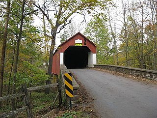
The Cabin Run Covered Bridge is a historic covered bridge located in Point Pleasant, Plumstead Township, Bucks County, Pennsylvania. The bridge was built in 1871, and is 15 feet (4.6 m) wide and has a length of 82 feet (25 m). The Town truss bridge crosses Cabin Run (creek) downstream from the Loux Covered Bridge.
The Frankenfield Covered Bridge is a wooden covered bridge that spans Tinicum Creek in Point Pleasant, Pennsylvania, United States. The bridge is located in Bucks County on Cafferty Road about 0.6 miles (1.0 km) southeast of Headquarters Road, near Vansant Airport, and a similar distance northwest of East Dark Hollow Road, near Palisades School District. Hollow Horn Road branches off from Cafferty Road a short distance from the south end of the span and goes south.

The Twin Bridges-West Paden Covered Bridge No. 121 is an historic, American, wooden, covered bridge that is located in Fishing Creek Township in Columbia County, Pennsylvania.

Loux Covered Bridge is a historic wooden covered bridge located on Wismer Road crossing Cabin Run (creek) upstream from the Cabin Run Covered Bridge in Bedminster Township and Plumstead Township, Bucks County, Pennsylvania. It was built in 1874 by David Sutton out of hemlock in the Town Truss style. This is one of the shorter covered bridges in Bucks County at only 60 feet (18 m) long.

Knecht's Covered Bridge is a historic covered bridge in Springfield Township, Bucks County, Pennsylvania. It crosses Cooks Creek on Knecht Bridge Road south of Springtown. Built in 1873 in the town truss style, the bridge is 110 feet long and 15 feet wide.

Campbell's Bridge formerly spanned Unami Creek on Allentown Road in Milford Square, Bucks County, Pennsylvania. The 72-foot-long (22 m), 20-foot-wide (6.1 m) bridge was built in 1906-1907. The bridge was designed by A. Oscar Martin and built by the Dailey Construction Company. It was one of the oldest examples of reinforced concrete arch bridges in the United States.

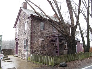
The Sheard's Mill Covered Bridge is located in East Rockhill Township and Haycock Township, Bucks County, Pennsylvania next to the Levi Sheard Mill. The bridge was built in 1873, and is 15-foot-wide (4.6 m) and 130-foot-long (40 m), making it one of Bucks County's longest bridges. The bridge crosses the Tohickon Creek on Covered Bridge Road.

The South Perkasie Covered Bridge is an historic, American wooden covered bridge that is located in Perkasie, Bucks County, Pennsylvania.

The Haupt's Mill Covered Bridge was an historic covered bridge that was located in Springfield Township, Bucks County, Pennsylvania. It crossed Durham Creek.

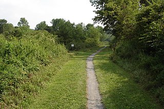
Cabin Run is a tributary of the Tohickon Creek in Bucks County, Pennsylvania, rising in the southwestern portion of Bedminster Township to its confluence with the Tohickon Creek in northeastern Plumstead Township. Its course is approximately 4.5 miles (7.2 km)


