Morrow Township, Missouri | |
|---|---|
 | |
| Coordinates: 40°17′02″N092°47′32″W / 40.28389°N 92.79222°W | |
| Country | United States |
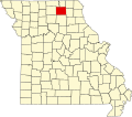
| State | Missouri |
| County | Adair |
| Area | |
• Total | 53.39 sq mi (138.27 km2) |
| • Land | 53.37 sq mi (138.22 km2) |
| • Water | 0.019 sq mi (0.05 km2) 0.04% |
| Elevation | 797 ft (243 m) |
| Population (2010) | |
• Total | 431 |
| • Density | 8.0/sq mi (3.1/km2) |
| FIPS code | 29-50096 [2] |
| GNIS feature ID | 0766213 |
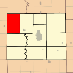
Morrow Township is one of ten townships in Adair County, Missouri, United States. As of the 2010 census, its population was 431. [3] It is named for John Morrow, one of Adair County's original judges. [4]