Mount Baldy (Salt Lake County, Utah)

Last updated
Mount Baldy
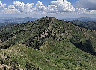
Mount Baldy from Clayton Peak.jpg
East-northeast aspect
Highest point
Elevation 11,068 ft (3,374 m) [1]
Prominence 368 ft (112 m) [1]
Parent peak Twin Peaks [1]
Isolation 1.4 mi (2.3 km) [1]
Coordinates 40°34′05″N111°38′17″W / 40.5679673°N 111.6380315°W / 40.5679673; -111.6380315 [2]
Geography
USA Utah relief location map.svg
Red triangle with thick white border.svg
Mount Baldy
Location in Utah
Usa edcp relief location map.png
Red triangle with thick white border.svg
Mount Baldy
Mount Baldy (the United States)
CountryUnited States
State Utah
County Salt Lake / Utah
Parent range Wasatch Range [3]
Rocky Mountains
Topo map USGS Dromedary Peak
Climbing
Easiest route class 1 hiking [1]

Mount Baldy is an 11,068-foot-elevation (3,374-meter) summit on the boundary that Salt Lake County shares with Utah County, in Utah, United States.

Contents

Description

Mount Baldy is located 19 miles (31 km) southeast of downtown Salt Lake City at the Alta Ski Area in the Wasatch–Cache National Forest. [3] The peak is part of the Wasatch Range which is a subrange of the Rocky Mountains. Precipitation runoff from the mountain's north slope drains to Little Cottonwood Creek, whereas the south slope drains into headwaters of the American Fork River. Topographic relief is significant as the summit rises approximately 3,000 feet (914 meters) above Little Cottonwood Canyon in 1.5 mile (2.4 km). This mountain's toponym has been officially adopted by the United States Board on Geographic Names. [2]

Climate

Mount Baldy has a subarctic climate (Köppen Dfc), bordering on an Alpine climate (Köppen ET), with long, cold, snowy winters, and cool to warm summers. [4] Due to its altitude, it receives precipitation all year, as snow in winter, and as thunderstorms in summer.

Related Research Articles

<span class="mw-page-title-main">Alta Ski Area</span> Ski resort in Alta, Utah, United States

Alta is a ski area in the western United States, located in the town of Alta in the Wasatch Mountains of Utah, in Salt Lake County. With a skiable area of 2,614 acres (10.58 km2), Alta's base elevation is 8,530 ft (2,600 m) and rises to 11,068 ft (3,374 m) for a vertical gain of 2,538 ft (774 m). One of the oldest ski resorts in the country, it opened its first lift in early 1939. Alta is known for receiving more snow than most Utah resorts, with an average annual snowfall of 545 inches (13.8 m). It is also regularly ranked as having the best snow in North America. Alta is one of three remaining ski resorts in the U.S. that prohibit snowboarders, along with nearby competitor Deer Valley and Vermont's Mad River Glen.

<span class="mw-page-title-main">Pfeifferhorn</span> Mountain in the American state of Utah

The Pfeifferhorn is the 11,326 feet (3,452 m) triangularly-shaped peak located in the most isolated part of the Lone Peak Wilderness Area of the Wasatch Mountains in northern Utah, United States. This rugged Utah mountain, commonly referred to as the Little Matterhorn, is the eighth-highest peak in the Wasatch Range. The summit can be reached by hiking, though some scrambling is required. There are several technical rock climbing routes with the north ridge being the most popular. This summit also makes an excellent winter mountaineering adventure.

<span class="mw-page-title-main">Ostler Peak</span> Mountain in the American state of Utah

Ostler Peak is a 12,718-foot elevation (3,876 m) mountain summit located in Summit County, Utah, United States.

<span class="mw-page-title-main">Dead Horse Peak</span> Mountain in the American state of Utah

Dead Horse Peak is a 12,642-foot elevation (3,853 m) mountain summit located on the common border that Duchesne County shares with Summit County in the U.S. state of Utah.

<span class="mw-page-title-main">Wasatch Peak</span> Mountain in the American state of Utah

Wasatch Peak is a 13,156-foot elevation (4,010 m) mountain summit located in Summit County, Utah, United States.

<span class="mw-page-title-main">Mount Raymond (Utah)</span> Mountain summit located in Salt Lake County, Utah, US

Mount Raymond is a 10,241-foot elevation (3,121 m) mountain summit located in Salt Lake County, Utah, United States.
<span class="mw-page-title-main">Gobblers Knob (Utah)</span> Mountain in the American state of Utah

Gobblers Knob is a 10,246-foot elevation (3,123 m) mountain summit located in Salt Lake County, Utah, United States.

<span class="mw-page-title-main">Kesler Peak (Wasatch Range)</span> Mountain in the American state of Utah

Kesler Peak is a 10,403-foot elevation (3,171 m) mountain summit located in Salt Lake County, Utah, United States.

<span class="mw-page-title-main">Spanish Fork Peak</span> Mountain peak in Utah County, United States

Spanish Fork Peak is a 10,192-foot elevation (3,107 m) mountain summit located in Utah County, Utah, United States.

<span class="mw-page-title-main">O'Sullivan Peak (Utah)</span> Mountain in Salt Lake County, Utah

O'Sullivan Peak, also known as Sunrise Peak, is an 11,275-foot-elevation (3,437-meter) mountain summit located in Salt Lake County, Utah, United States.

<span class="mw-page-title-main">Box Elder Peak (Utah County, Utah)</span> Mountain in Utah, United States

Box Elder Peak is an 11,101-foot-elevation (3,384-meter) mountain summit located in Utah County, Utah, United States.

<span class="mw-page-title-main">Sugarloaf Mountain (Utah)</span> Mountain in Utah, United States

Sugarloaf Mountain is an 11,051-foot-elevation (3,368-meter) summit on the boundary that Salt Lake County shares with Utah County, in Utah, United States.

<span class="mw-page-title-main">Clayton Peak</span> Mountain in Utah, United States

Clayton Peak, also known unofficially as Mount Majestic, is a 10,721-foot-elevation (3,268-meter) summit on the boundary that Salt Lake County shares with Wasatch County, in Utah, United States.

<span class="mw-page-title-main">Mount Millicent</span> Mountain in Utah, United States

Mount Millicent is a 10,452-foot-elevation (3,186-meter) summit in Salt Lake County, Utah, United States.

<span class="mw-page-title-main">Mount Wolverine</span> Mountain in Utah, United States

Mount Wolverine is a 10,795-foot-elevation (3,290-meter) summit in Salt Lake County, Utah, United States.

<span class="mw-page-title-main">Sunset Peak (Utah)</span> Mountain in Utah, United States

Sunset Peak is a 10,648-foot-elevation (3,246-meter) summit in Utah, United States.

<span class="mw-page-title-main">Reids Peak</span> Mountain summit in Utah, United States

Reids Peak is an 11,724-foot-elevation (3,573-meter) mountain summit in Summit County, Utah, United States.

<span class="mw-page-title-main">Notch Mountain (Utah)</span> Mountain in Summit County, Utah, United States

Notch Mountain is an 11,263-foot-elevation (3,433-meter) mountain summit in Summit County, Utah, United States.

<span class="mw-page-title-main">Dromedary Peak</span> Mountain in Utah, United States

Dromedary Peak is an 11,107-foot-elevation (3,385-meter) mountain summit located in Salt Lake County, Utah, United States.

<span class="mw-page-title-main">Mount Tuscarora (Utah)</span> Mountain in Utah, United States

Mount Tuscarora is a 10,646-foot-elevation (3,245-meter) summit in Salt Lake County, Utah, United States.

References

  1. 1 2 3 4 5 "Baldy, Mount - 11,068' UT". listsofjohn.com. Retrieved 2024-06-04.
  2. 1 2 "Mount Baldy". Geographic Names Information System . United States Geological Survey, United States Department of the Interior . Retrieved 2024-06-04.
  3. 1 2 "Mount Baldy, Utah". Peakbagger.com. Retrieved 2024-06-04.
  4. Peel, M. C.; Finlayson, B. L.; McMahon, T. A. (2007). "Updated world map of the Köppen−Geiger climate classification". Hydrol. Earth Syst. Sci. 11. ISSN   1027-5606.