Mount Carillon

Last updated
Mount Carillon
Mt. Carillon.jpg
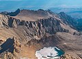
Mt. Carillon centered at top, south aspect
(Mt. Russell in upper left corner)
Highest point
Elevation 13,559 ft (4,133 m)  NAVD 88 [1]
Prominence 233 ft (71 m) [1]
Parent peak Mount Russell (14,088 ft) [1]
Isolation 0.41 mi (0.66 km) [1]
Listing Sierra Peaks Section
Coordinates 36°35′33″N118°16′40″W / 36.5924211°N 118.2779091°W / 36.5924211; -118.2779091 Coordinates: 36°35′33″N118°16′40″W / 36.5924211°N 118.2779091°W / 36.5924211; -118.2779091 [2]
Naming
Etymology Carillon
Geography
Relief map of California.png
Red triangle with thick white border.svg
Mount Carillon
Usa edcp relief location map.png
Red triangle with thick white border.svg
Mount Carillon
Location Sequoia National Park
Tulare County / Inyo County
California, U.S.
Parent range Sierra Nevada
Topo map USGS Mount Whitney
Geology
Age of rock Cretaceous
Mountain type Fault block
Type of rock granitic
Climbing
First ascent 1925, Norman Clyde
Easiest route Simple scramble class 2+ [3]

Mount Carillon is a 13,559-foot-elevation (4,133-meter) mountain summit located on the crest of the Sierra Nevada mountain range in California. [2] It is situated on the common border of Tulare County with Inyo County, as well as the shared boundary of Sequoia National Park and John Muir Wilderness. It is set above the south shore of Tulainyo Lake, 12.5 miles (20.1 km) west of the community of Lone Pine, 1.25 miles (2.01 km) northeast of Mount Whitney, and 0.7 miles (1.1 km) east-northeast of Mount Russell, the nearest higher neighbor. Topographic relief is significant as it rises approximately 5,180 feet (1,580 meters) above Whitney Portal in approximately two miles. Carillon has subpeaks, unofficially called "The Cleaver" (13,383 ft (4,079 m), 0.4 mile to the northeast, and "Impala" (12,073+ ft/3,680+ m), on the southeast ridge. [1]

Contents

History

The first ascent of the summit was made in 1925, by Norman Clyde, who is credited with 130 first ascents, most of which were in the Sierra Nevada. [4] [5] The peak's name was submitted by Chester Versteeg of the Sierra Club, and officially adopted by the United States Board on Geographic Names in 1937. [2] It is so named because it is shaped like a bell tower, which often houses a carillon. [6]

Climate

According to the Köppen climate classification system, Mount Carillon has an alpine climate. [7] Most weather fronts originate in the Pacific Ocean, and travel east toward the Sierra Nevada mountains. As fronts approach, they are forced upward by the peaks, causing them to drop their moisture in the form of rain or snowfall onto the range (orographic lift). Precipitation runoff from this mountain drains west to the Kern River via Wallace Creek, and east to Owens Valley via Lone Pine Creek.

Climbing

Established climbing routes: [8]

See also

Related Research Articles

<span class="mw-page-title-main">Mount Whitney</span> Highest mountain in California, United States

Mount Whitney is the highest mountain in the contiguous United States and the Sierra Nevada, with an elevation of 14,505 feet (4,421 m). It is in East–Central California, on the boundary between California's Inyo and Tulare counties, 84.6 miles (136.2 km) west-northwest of North America's lowest point, Badwater Basin in Death Valley National Park, at 282 ft (86 m) below sea level. The mountain's west slope is in Sequoia National Park and the summit is the southern terminus of the John Muir Trail, which runs 211.9 mi (341.0 km) from Happy Isles in Yosemite Valley. The eastern slopes are in Inyo National Forest in Inyo County.

<span class="mw-page-title-main">Mount Muir</span> Mountain of the Sierra Nevada in California, United States

Mount Muir is a peak in the Sierra Nevada of California, 0.95 miles (1.5 km) south of Mount Whitney. This 14,018-foot (4,273 m) peak is named in honor of Scottish-born John Muir, a famous geologist, conservationist and founder of the Sierra Club. The southernmost section of the John Muir Trail contours along the west side of Mount Muir near its summit and ends on the summit of Mount Whitney.

<span class="mw-page-title-main">Mount Russell (California)</span>

Mount Russell is a peak in the Sierra Nevada mountain range in the U.S. state of California, about 0.8 miles (1.3 km) north of Mount Whitney. With an elevation of 14,094 feet (4,296 m) it is the seventh-highest peak in the state.

<span class="mw-page-title-main">Mount Tyndall</span>

Mount Tyndall is a peak in the Mount Whitney region of the Sierra Nevada in the U.S. state of California. At 14,025 feet (4,275 m), it is the tenth highest peak in the state. The mountain was named in honor of the Irish scientist and mountaineer, John Tyndall.

<span class="mw-page-title-main">Palisades (California Sierra)</span> Group of mountains within the Sierra Nevada of California, United States

The Palisades are a group of peaks in the central part of the Sierra Nevada in the U.S. state of California. They are located about 12 miles (19 km) southwest of the town of Big Pine, California. The peaks in the group are particularly steep, rugged peaks and "contain the finest alpine climbing in California." The group makes up about 6 miles (10 km) of the Sierra Crest, which divides the Central Valley watershed from the Owens Valley, and which runs generally northwest to southeast.

<span class="mw-page-title-main">Mount McAdie</span>

Mount McAdie is a summit on the crest of the Sierra Nevada, and is located 2.1 miles (3.4 km) south of Mount Whitney. It has three summits, with the north peak being the highest. The summit ridge marks the boundary between Sequoia National Park and the John Muir Wilderness. It is also on the boundary between Inyo and Tulare counties. Lone Pine, 12.4 miles (20.0 km) to the northeast, is in the Owens Valley on U.S. 395.

<span class="mw-page-title-main">Mount Thompson (California)</span>

Mount Thompson is a 13,494-foot-elevation mountain summit located on the crest of the Sierra Nevada mountain range in California, United States. It is situated on the shared boundary of Kings Canyon National Park with John Muir Wilderness, and along the common border of Fresno County with Inyo County. It is also 18 miles (29 km) west of the community of Big Pine, one mile northwest of Mount Gilbert, and three miles east of Mount Fiske, which is the nearest higher neighbor. Mount Thompson ranks as the 62nd-highest summit in California. This mountain's name commemorates Almon Harris Thompson (1839–1906). The first ascent of the peak was made by Clarence H. Rhudy and H. F. Katzenbach in the summer of 1909.

<span class="mw-page-title-main">Mount Gayley</span>

Mount Gayley is a 13,510-foot-elevation mountain summit located one mile east of the crest of the Sierra Nevada mountain range in Inyo County, California, United States. It is situated in the Palisades area of the John Muir Wilderness, on land managed by Inyo National Forest. It is approximately 13 miles (21 km) west-southwest of the community of Big Pine, 0.67 miles (1.08 km) southwest of Temple Crag, and 0.5 miles (0.80 km) north-northeast of parent Mount Sill. Mount Gayley ranks as the 59th highest summit in California.

<span class="mw-page-title-main">Mount Haeckel</span>

Mount Haeckel is a 13,424-foot (4,092 m) mountain summit located on the crest of the Sierra Nevada mountain range in northern California, United States. It is situated on the shared boundary of Kings Canyon National Park with John Muir Wilderness, and along the common border of Fresno County with Inyo County. It is 21.5 miles (34.6 km) west of the community of Big Pine, 1.27 miles (2.04 km) south-southeast of Mount Darwin, and one mile north-northeast of Mount Fiske, which is the nearest higher neighbor. Mount Haeckel ranks as the 71st highest summit in California.

<span class="mw-page-title-main">North Guard</span>

North Guard is a remote 13,327-foot-elevation (4,062-meter) mountain summit located near the northern end of the Great Western Divide of the Sierra Nevada mountain range, in Tulare County of northern California. It is situated in Kings Canyon National Park, 0.9 miles (1.4 km) southeast of Mount Farquhar, and 0.6 miles (0.97 km) north-northwest of Mount Brewer, which is the nearest higher neighbor. Topographic relief is significant as the east aspect rises 3,858 feet above East Lake in three miles. North Guard ranks as the 87th highest summit in California, and the second highest point of the northern Great Western Divide. It's not as high as Mount Brewer, but offers better climbing and is considered one of the classic climbing routes in the Sierra Nevada.

<span class="mw-page-title-main">Thor Peak (California)</span>

Thor Peak is a 12,306-foot-elevation (3,751-meter) mountain summit located east of the crest of the Sierra Nevada mountain range in Inyo County, California. It is situated in the John Muir Wilderness on land managed by Inyo National Forest. It is 12.5 miles (20.1 km) west of the community of Lone Pine, and 1.5 miles (2.4 km) east of Mount Whitney. Topographic relief is significant as it rises 3,937 feet above Whitney Portal in 1.5 mile. Hikers on the Mount Whitney Trail pass below the impressive south face of the peak.

<span class="mw-page-title-main">Mount Chamberlin (California)</span> Mountain summit located of the Sierra Nevada mountain range in Tulare County, California

Mount Chamberlin is a 13,169-foot-elevation (4,014 meter) mountain summit located west of the crest of the Sierra Nevada mountain range in Tulare County, California. It is situated in Sequoia National Park, and is 3.2 miles (5.1 km) south-southwest of Mount Whitney, 1.5 mile (2.4 km) south of Mount Hitchcock, and 3.5 miles west of Mount Corcoran. Topographic relief is significant as it rises approximately 1,830 feet (558 meters) above Crabtree Lakes in one-half mile. Mt. Chamberlin ranks as the 119th highest summit in California. This mountain's name was officially adopted in 1940 by the U.S. Board on Geographic Names to honor American geologist Thomas Chrowder Chamberlin (1843–1928). The first ascent of the summit was made by Sierra Club member J. H. Czock, date unknown.

<span class="mw-page-title-main">Mount Newcomb</span>

Mount Newcomb is a 13,422-foot-elevation (4,091-meter) mountain summit located just west of the crest of the Sierra Nevada mountain range in Tulare County, California. It is situated in Sequoia National Park, and is 2.8 miles (4.5 km) south of Mount Whitney, 1.1 miles (1.8 km) northeast of Mount Chamberlin, and 3.5 miles west of Mount Corcoran. Mt. Newcomb ranks as the 70th highest summit in California. Topographic relief is significant as it rises 2,083 feet above the second Crabtree Lake in approximately one mile. This mountain's name was officially adopted in 1940 by the U.S. Board on Geographic Names to honor American astronomer Simon Newcomb (1835–1909). The first ascent of the summit was made August 22, 1936, by Max Eckenburg and Bob Rumohr.

<span class="mw-page-title-main">Mount Johnson (California)</span>

Mount Johnson is a 12,871-foot-elevation mountain summit located on the crest of the Sierra Nevada mountain range in California, United States. It is situated on the boundary between Kings Canyon National Park and John Muir Wilderness, and along the county line between Fresno County and Inyo County. It is also 18 miles (29 km) west of the community of Big Pine, 0.9 miles (1.4 km) southeast of Mount Gilbert, and one mile (1.6 km) west-northwest of Mount Goode. Mount Johnson ranks as the 187th-highest summit in California. Topographic relief is significant as the southwest aspect rises 3,670 feet above LeConte Canyon in 1.5 mile, and the north aspect rises 3,100 feet above South Lake in 2.5 miles.

<span class="mw-page-title-main">Tunnabora Peak</span> Mountain in California

Tunnabora Peak is a 13,563-foot-elevation (4,134-meter) mountain summit located on the crest of the Sierra Nevada mountain range in California. It is situated on the common border of Tulare County with Inyo County, as well as the shared boundary of Sequoia National Park and John Muir Wilderness. It is set above the north shore of Tulainyo Lake, 13 miles (21 km) west of the community of Lone Pine, 1.86 miles (2.99 km) north-northeast of Mount Whitney, and 0.9 miles (1.4 km) north-northwest of Mount Carillon. Tunnabora ranks as the 51st-highest peak in California. Topographic relief is significant as it rises approximately 5,200 feet above Whitney Portal in approximately three miles.

<span class="mw-page-title-main">Mount Randy Morgenson</span>

Mount Randy Morgenson is a 13,927-foot-elevation (4,245-meter) mountain summit located along the crest of the Sierra Nevada mountain range in Tulare County, California. It is situated in Sequoia National Park, one mile north-northwest of Mount Whitney, 0.85 mile east of Mount Hale, and one-half mile west of Mount Russell, the nearest higher neighbor. The John Muir Trail traverses to the south of the mountain, providing an approach option. Mt. Morgenson ranks as the 20th-highest summit in California. Topographic relief is significant as the northwest aspect rises 2,200 feet above Wales Lake in less than one mile.

<span class="mw-page-title-main">Mount Wallace (Fresno and Inyo counties, California)</span>

Mount Wallace is a 13,377-foot-elevation mountain summit located on the crest of the Sierra Nevada mountain range in northern California, United States. It is situated on the shared boundary of Kings Canyon National Park with John Muir Wilderness, and along the common border of Fresno County with Inyo County. It is 21 miles (34 km) west of the community of Big Pine, 1.38 miles (2.22 km) northwest of Mount Powell, 0.5 miles (0.80 km) southwest of Picture Peak, and 0.37 miles (0.60 km) southeast of Mount Haeckel, which is the nearest higher neighbor. Mount Wallace ranks as the 79th-highest summit in California, and the ninth-highest in the Evolution Region.

<span class="mw-page-title-main">Mount Starr</span>

Mount Starr, elevation 12,835 feet (3,912 m), is a mountain summit located on the crest of the Sierra Nevada mountain range in northern California, United States. It is situated in the John Muir Wilderness on the common boundary shared by Sierra National Forest with Inyo National Forest, and along the common border of Fresno County with Inyo County. It is bound on the east by Little Lakes Valley, and is 0.8 mile northeast of Mono Pass. Topographic relief is significant as the summit rises 2,300 feet above Little Lakes Valley in approximately one-half mile (0.80 km). Neighbors include Mount Abbot, three miles to the south-southwest, Mount Morgan, 2.5 miles to the southeast, and Pointless Peak is 2.5 miles to the north.

<span class="mw-page-title-main">Pyramid Peak (Fresno County, California)</span>

Pyramid Peak is a 12,779-foot-elevation (3,895 meter) mountain summit located west of the crest of the Sierra Nevada mountain range, in Fresno County, California, United States. It is situated in Kings Canyon National Park, 2.2 miles (3.5 km) southwest of line parent Mount Ickes and 2.2 miles (3.5 km) southeast of Arrow Peak, which is the nearest higher neighbor. Other nearby peaks include Crater Mountain 2.5 miles (4.0 km) to the northeast, and Window Peak one mile to the south. Pyramid Peak ranks as the 214th-highest summit in California, and topographic relief is significant as the southwest aspect rises over 2,300 feet in approximately one mile.

<span class="mw-page-title-main">Tulainyo Lake</span> Lake in California, United States

Tulainyo Lake is a freshwater alpine lake in the eastern Sierra Nevada in the U.S. state of California, and one of the highest and largest of the alpine lakes of the Sierra. It lies in a large granite bowl bounded by the Sierra Crest to the north, east, and south, at an altitude of 12,829 ft (3,910 m). It lies within Sequoia National Park and the Sequoia-Kings Canyon Wilderness, in close proximity (less than 1.25 miles to Mount Whitney, the highest peak in the contiguous United States.

References

  1. 1 2 3 4 5 "Mount Carillon, California". Peakbagger.com. Retrieved 2021-05-21.
  2. 1 2 3 "Mount Carillon". Geographic Names Information System . United States Geological Survey, United States Department of the Interior . Retrieved 2021-05-21.
  3. Roper, Steve (1976). The Climber's Guide to the High Sierra. San Francisco: Sierra Club Books. p. 304. ISBN   978-0871561473.
  4. Mendenhall, John D. and Ruth; Johnson, Arthur B.; Gigas, Braeme; Koster, Howard (1954). "A Climber's Guide to the High Sierra". Yosemite Online. Retrieved 2021-11-05.
  5. "Norman Clyde - Mountaineer". OwensValleyHistory.com. Retrieved 2021-11-05.
  6. Gudde, Erwin G. (1969). California Place Names. University of California Press. p. 66. ISBN   978-0520266193.
  7. Peel, M. C.; Finlayson, B. L.; McMahon, T. A. (2007). "Updated world map of the Köppen−Geiger climate classification". Hydrol. Earth Syst. Sci. 11 (5): 1633. Bibcode:2007HESS...11.1633P. doi: 10.5194/hess-11-1633-2007 . ISSN   1027-5606.
  8. Secor, R.J. (2009). The High Sierra Peaks, Passes, and Trails (3rd ed.). Seattle: The Mountaineers. p. 254. ISBN   978-0898869712.
  9. Har-Noy, Shay (2009). "Mt. Carillon, Sweet Carillon and Pipe-Line". American Alpine Journal. Retrieved 2021-11-05.