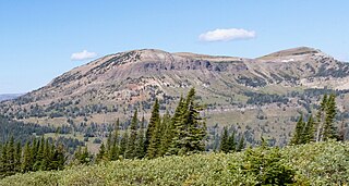
Mount Delano | |
---|---|
Highest point | |
Elevation | 10,159 ft (3,096 m) [1] |
Prominence | 664 ft (202 m) [1] |
Parent peak | Mount McKnight (10,310 ft) [2] |
Isolation | 1.99 mi (3.20 km) [2] |
Coordinates | 45°31′25″N110°28′17″W / 45.5234814°N 110.4712797°W [3] |
Naming | |
Etymology | Columbus Delano |
Geography | |
Country | United States |
State | Montana |
County | Park |
Protected area | Absaroka-Beartooth Wilderness [1] |
Parent range | Absaroka Range |
Topo map | USGS Livingston Peak |
Mount Delano is a 10,159-foot (3,096-metre) mountain summit in Park County, Montana, United States.
Mount Delano is located nine miles (14 km) south-southeast of Livingston in the northern Absaroka Range, which is a subrange of the Rocky Mountains. [1] It is situated in the Absaroka-Beartooth Wilderness on land managed by Gallatin National Forest, and can be seen from Highway 89 when travelling between Livingston and Yellowstone National Park. Precipitation runoff from the mountain drains into the north and south forks of Deep Creek which is a tributary of the Yellowstone River. Topographic relief is significant as the summit rises 3,000 feet (914 meters) above the South Fork in 0.9 miles (1.4 km); 4,000 feet (1,219 meters) above the North Fork in two miles (3.2 km); and 5,500 feet (1,676 meters) above the Yellowstone in five miles (8.0 km). The mountain's toponym, which honors Columbus Delano (1809–1896), has been officially adopted by the United States Board on Geographic Names, [3] and has been printed in publications since at least 1873. [4] Delano served as President Ulysses S. Grant's Secretary of the Interior and he was instrumental in the establishment of America's first national park, Yellowstone.
Based on the Köppen climate classification, Mount Delano is located in a subarctic climate zone characterized by long, usually very cold winters, and mild summers. [5] Winter temperatures can drop below 0 °F with wind chill factors below −10 °F.
Bannock Peak is a 10,329-foot (3,148-metre) mountain summit in the southern section of the Gallatin Range in Yellowstone National Park, in the U.S. state of Wyoming. The peak ranks as the sixth-highest peak in the Gallatin Range. Precipitation runoff from the mountain drains west into headwaters of the Gallatin River and east into Panther Creek which is a tributary of the Gardner River. Topographic relief is significant as the summit rises nearly 2,000 feet above Panther Creek in one mile (1.6 km). This mountain's toponym was officially adopted in 1897 by the United States Board on Geographic Names.
Amphitheater Mountain is a prominent 11,042-foot-elevation (3,366-meter) mountain summit located in Park County, Wyoming, United States.
Cutoff Mountain is a 10,695-foot (3,260-metre) mountain summit located in Park County, Montana.
Pollux Peak is an 11,063-foot-elevation (3,372-meter) mountain summit located in Yellowstone National Park, in Park County, Wyoming, United States.
Saddle Mountain is a 10,670-foot-elevation (3,250-meter) mountain summit located in Yellowstone National Park, in Park County, Wyoming, United States.
Lonesome Mountain is an 11,399-foot (3,474-metre) mountain summit located in Carbon County, Montana.
Wolf Mountain is an 11,808-foot (3,599-metre) mountain summit located in Park County, Montana.
Hoodoo Peak is a 10,571-foot-elevation (3,222-meter) mountain summit located in Park County, Wyoming, United States.
Black Mountain is a 10,941-foot (3,335-metre) summit located in Park County, Montana, United States.
Gardner Point is a 7,405-foot-elevation (2,257-meter) mountain summit in Flathead County, Montana.
Boat Mountain is a 9,071-foot (2,765-metre) mountain summit in Gallatin County, Montana, United States.
Sheep Mountain is a 10,552-foot (3,216-metre) mountain summit in Park County, Montana, United States.
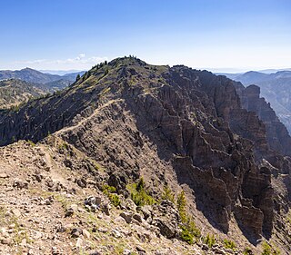
Big Horn Peak is a 9,935-foot (3,028-metre) mountain summit in Gallatin County, Montana, United States.
Ramshorn Peak is a 10,296-foot (3,138-metre) mountain summit in Gallatin County, Montana, United States.
Steamboat Mountain is a 10,030-foot (3,057-metre) mountain summit in Gallatin County, Montana, United States.
Sheep Mountain is a 10,097-foot (3,078-metre) mountain summit in Park County, Montana, United States.
Fisher Mountain is a 10,246-foot (3,123-metre) summit in Park County, Montana, United States.
Scotch Bonnet Mountain is a 10,385-foot (3,165-metre) summit in Park County, Montana, United States.
Sheep Mountain is a 10,608-foot (3,233-metre) summit in Park County, Montana, United States.
Henderson Mountain is a 10,343-foot (3,153-metre) summit in Park County, Montana, United States.