| Cutoff Mountain | |
|---|---|
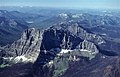
 North aspect | |
| Highest point | |
| Elevation | 10,695 ft (3,260 m) [1] |
| Prominence | 1,735 ft (529 m) [1] |
| Parent peak | Abiathar Peak (10,928 ft) [2] |
| Isolation | 5.66 mi (9.11 km) [2] |
| Listing | Mountain peaks of Montana |
| Coordinates | 45°01′55″N110°06′56″W / 45.0319221°N 110.1156054°W [3] |
| Geography | |
 Cutoff Mountain Location in Montana  Cutoff Mountain Cutoff Mountain (the United States) | |
| Country | United States |
| State | Montana |
| County | Park |
| Protected area | Absaroka-Beartooth Wilderness |
| Parent range | Absaroka Range |
| Topo map | USGS Cutoff Mountain |
| Geology | |
| Rock age | Eocene |
| Rock type | breccia |
| Climbing | |
| Easiest route | class 3 scrambling [2] |
Cutoff Mountain is a 10,695-foot (3,260-metre) mountain summit located in Park County, Montana. [3]