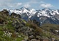
Mount Constance is a peak in the Olympic Mountains of Washington and the third highest in the range. It is the most visually prominent peak on Seattle's western skyline. Despite being almost as tall as the ice-clad Mount Olympus to the west, Mount Constance has little in the way of glaciers and permanent snow because the eastern, and particularly this northeastern, portion of the Olympics receives far less precipitation. However the narrow and steep Crystal Glacier still exists on the mountain's north face, shaded by the bulk of the main peak and with a small lake at its terminus. In addition, the treeline is higher here than mountains to the west, also hinting at the drier alpine conditions.

Mount Deception is a peak in the Olympic Mountains of Cascadia. It is in Olympic National Park on the Olympic Peninsula in the U.S. state of Washington.

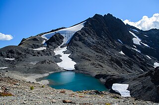
Inner Constance is a summit of the Olympic Mountains and is located in Jefferson County of Washington state. It is located near the eastern edge of Olympic National Park on the Olympic Peninsula. At 7,670 feet (2,338 m), Inner Constance is the fifth-highest peak of the Olympic Mountains, after Mount Olympus, Mount Deception, Mount Constance, and Mount Johnson. Its nearest higher neighbor is Mount Constance, 0.9 mi (1.4 km) to the east. Within this nearly mile-wide separation resides a deep glacially carved canyon called "Avalanche Canyon". Precipitation runoff on the north side of the peak drains into tributaries of the Dungeness River, whereas the south side drains into tributaries of the Dosewallips River.

Mount LaCrosse, is a 6,417-foot (1,956-metre) mountain summit in the Olympic Mountains and is located in Jefferson County of Washington state. It is situated in Olympic National Park and the nearest higher peak is Mount Elk Lick, 2.54 mi (4.09 km) to the east. The Anderson massif lies 2.67 mi (4.30 km) to the north of Mount LaCrosse, and White Mountain lies 0.95 mi (1.53 km) to the southwest. Precipitation runoff from the mountain drains into tributaries of the Dosewallips River and Duckabush River.

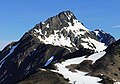
Warrior Peak is a 7,320+ ft double summit mountain located in Olympic National Park and Jefferson County of Washington state. Warrior is the 11th-highest peak in the Olympic Mountains. The southeast summit is the slightly higher of the two summits, the northwest peak is estimated at 7,285 feet elevation. Precipitation runoff from the west side of the mountain drains into Home Creek, a tributary of the Dungeness River, whereas the east side drains into Tunnel Creek which is a tributary of the Big Quilcene River. Warrior Peak is easy to identify from Seattle, since it appears as the first prominent peak immediately north of Mount Constance, which is the dominant peak on the skyline. Warrior's nearest higher peak is Mount Constance, 0.8 mi (1.3 km) to the south-southeast. The first ascent of the mountain was made in 1945 by Fred Beckey, who solo climbed both summits, and named the mountain.

Mount Tom is a remote 7,076-foot (2,157-metre) mountain summit located within Olympic National Park in Jefferson County of Washington state. The nearest higher neighbor is Mount Olympus, 1.76 mi (2.83 km) to the east. Due to heavy winter snowfalls, Mount Tom supports the massive White Glacier on its northeast slope, despite its modest elevation. This glacier is the westernmost glacier in the contiguous states, and the summit is the westernmost peak higher than 7000+ feet elevation. Precipitation runoff from the mountain drains into tributaries of the Hoh River.
West Peak is a 7,365-foot-elevation (2,245 m) summit in the Olympic Mountains, in Jefferson County of Washington state. Rising in the center of Olympic National Park, it is the highest peak on the Anderson Massif. West Peak is the hydrographic apex of the Olympic Mountains, with precipitation runoff flowing outward to the Pacific Ocean via Quinault River, the Strait of Juan de Fuca via Elwha River, and Hood Canal via the Dosewallips River. The Eel Glacier is situated in a cirque east of the summit, and an unnamed glacier resides in the south cirque. The nearest higher peak is Mount Mystery, 7.73 miles (12.44 km) to the northeast. The first ascent of the peak was made in 1930 by E. B. Hamilton. Legend has it that the mountain's name is for Mr. West, a participant in the 1890 O'Neil Expedition, rather than for its apparent position on the Anderson Massif. The West Branch of the Quinault River was named after him in 1890.
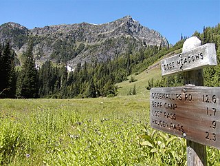
Sentinel Peak is a 6,592-foot-high (2,009 m) mountain summit located in the Olympic Mountains, in Jefferson County of Washington state. Rising in the center of Olympic National Park, its nearest higher neighbor is Mount Fromme, 1.42 miles (2.29 km) to the northwest. Sentinels Sister is a lower 6,301-foot-high (1,921 m) companion summit situated 0.65 miles (1.05 km) to the southwest. The two peaks stand as sentinels above the Dosewalips Valley and Hayden Pass, and were possibly named by an early expedition of the Seattle Mountaineers. Precipitation runoff from the peak drains to Hood Canal via the Dosewallips River.

Mount Fricaba is a 7,139-foot-elevation (2,176 m) double summit mountain located in the Olympic Mountains, in Jefferson County of Washington state. It is situated on the shared border of Olympic National Park with Buckhorn Wilderness, and is the highest point in that wilderness, as well as the Olympic National Forest. Its nearest higher peak is Hal Foss Peak, 0.74 miles (1.19 km) to the southwest. Precipitation runoff from the peak drains east into headwaters of the Dungeness River, or west into Deception Creek which is a tributary of the Dosewallips River. The mountain's name was officially adopted in 1961 by the United States Board on Geographic Names based on usage by The Mountaineers since 1907, and inclusion in Fred Beckey's "Climber's Guide to the Cascade and Olympic Mountains of Washington" published in 1949. The first ascent of the mountain was made in 1957 by Don Bechlem and Jack Newman.

Mount Ferry is a 6,195-foot (1,888-metre) mountain summit located within Olympic National Park in Jefferson County of Washington state. Mount Ferry is the eighth-highest peak in the Bailey Range, which is a subrange of the Olympic Mountains. In clear weather, the mountain can be seen from the visitor center at Hurricane Ridge. Its nearest higher neighbor is Mount Pulitzer, 0.6 mi (0.97 km) to the southwest. Stephen Peak is set 2.26 mi (3.64 km) to the northwest, and Mount Olympus is 7.2 mi (11.6 km) to the southwest. Precipitation runoff from the mountain drains into tributaries of the Elwha and Hoh Rivers.
Mount Pulitzer, also known as Snagtooth, is a 6,283-foot (1,915-metre) mountain summit located within Olympic National Park in Jefferson County of Washington state. Mount Pulitzer is the sixth-highest peak in the Bailey Range, which is a subrange of the Olympic Mountains. Its nearest neighbor is Mount Ferry, 0.58 mi (0.93 km) to the northeast, and its nearest higher neighbor is Stephen Peak, 2.58 mi (4.15 km) to the north. Mount Olympus is set 6.8 mi (10.9 km) to the southwest. In clear weather, the mountain can be seen from the visitor center at Hurricane Ridge. Precipitation runoff from the mountain drains into tributaries of the Elwha and Hoh Rivers. The first ascent of the summit was made in 1961 by Doug Waali, Bob Wood, and Kent Heathershaw via the east ridge.

Mount Mathias is a 7,156-foot (2,181-metre) mountain summit located within Olympic National Park in Jefferson County of Washington state. Its nearest higher neighbor is Mount Olympus, 1.76 mi (2.83 km) to the east. Mount Mathias is wedged between the massive Blue Glacier below its west slope, and the Hoh Glacier on the east side. Precipitation runoff from the mountain drains into the Hoh River.

Aries is a 6,533-foot (1,991-metre) mountain summit located within Olympic National Park in Jefferson County of Washington state. Its neighbors include Mount Olympus, 2.46 mi (3.96 km) to the west, Athena 1.7 mi (2.7 km) to the southwest, and Mount Mathias 1.11 mi (1.79 km) to the northwest. Aries is wedged between the Hoh Glacier and the Humes Glacier, and immediately northeast of Blizzard Pass. Precipitation runoff from the mountain drains into headwaters of the Queets and Hoh Rivers. This mountain was named by glaciologists Richard Hubley and Edward LaChapelle in 1955, in preparation for the International Geophysical Year. It is named for Aries in keeping with the Greek and Roman mythology naming theme surrounding Mount Olympus.

Mount Claywood is a 6,836-foot (2,084-metre) mountain summit located within Olympic National Park in Jefferson County of Washington state. It is situated at the head of Lost River, and 15 mi (24 km) east of Mount Olympus. Its nearest higher neighbor is Mount Cameron, 2.4 mi (3.9 km) to the northeast. Other nearby peaks include Mt. Fromme, 0.58 mi (0.93 km) to the southeast, and Sentinel Peak, 2 mi (3.2 km) also to the southeast. Precipitation runoff from the mountain drains north and west into tributaries of the Elwha River, and east into Claywood Lake, thence Dosewallips River.
Woden is a 6,038-foot (1,840-metre) mountain summit located within Olympic National Park in Jefferson County of Washington state. Its nearest higher neighbor is Mount Tom, 3 mi (4.8 km) to the north-northwest, and Mount Olympus rises 3.8 mi (6.1 km) to the north-northeast. Woden is the highest point in The Valhallas, a sub-range south of Mount Olympus. Precipitation runoff from the mountain drains into tributaries of the South Fork Hoh River and Queets River. The Geri-Freki Glacier, which descends north from Woden. is the only glacier in The Valhallas.

Athena is a 7,365-foot-elevation (2,245 meter) mountain summit located within Olympic National Park in Jefferson County of Washington state. Athena is situated at the head of the Hoh Glacier, and the Hubert Glacier lies below the west aspect. Its neighbors include Mount Olympus, 1.7 mi (2.7 km) to the northwest, and Aries 1.7 mi (2.7 km) to the northeast. Athena has subpeaks "Athena II" (7,259 ft), and "Athena's Owl" (7,000 ft). Precipitation runoff from the mountain drains into the Queets and Hoh Rivers, with Athena being the highest point within the Queets drainage basin.
Mount Cameron is a 7,190-foot-elevation (2,192-meter) triple-summit mountain located within Olympic National Park in Jefferson County of Washington state. Mount Cameron is situated 21 miles southwest of Sequim, and set within the Daniel J. Evans Wilderness. Topographic relief is significant as the southeast aspect rises over 3,300 feet above the Dosewallips River in approximately one mile. Precipitation runoff from the mountain drains south into the Dosewallips River, north to the Gray Wolf River via Cameron Creek, and west into headwaters of Lost River. Neighbors include line parent Mount Deception, 4.5 mi (7.2 km) to the east, and proximate parent Mount Johnson, 4.5 mi (7.2 km) to the east.

Mount Wilder is a 5,939-foot (1,810-metre) mountain summit located near the head of the Elwha Valley, deep within Olympic National Park in Jefferson County of Washington state. Part of the Olympic Mountains, Wilder represents the southernmost peak of the Bailey Range. It is situated 8.7 miles east-southeast of Mount Olympus, and is set within the Daniel J. Evans Wilderness. Neighbors include line parent Mount Dana, 2.3 miles (3.7 km) to the northeast, and Mount Seattle rises 3.7 miles to the southwest. The headwaters of the Goldie River form on the south slope of the mountain, and precipitation runoff from the mountain drains into Goldie River and other tributaries of the Elwha River. Topographic relief is significant as the south aspect of the peak rises nearly 3,800 feet (1,160 m) in less than two miles.
Mount Fromme is a 6,705-foot (2,044-metre) mountain summit in Olympic National Park in Jefferson County of Washington state. It is situated at the head of Dosewallips River, within the Daniel J. Evans Wilderness. The nearest higher neighbor is Mount Claywood, 0.6 mi (0.97 km) to the northwest. Other nearby peaks include Lost Peak, 1.8 mi (2.9 km) to the northeast, and Sentinel Peak, 1.4 mi (2.3 km) to the southeast. Precipitation runoff from the mountain drains east into headwaters of the Dosewallips River, and west into Hayes River, which is a tributary of the Elwha River. Topographic relief is significant as the summit rises 2,250 feet (685 m) above Dose Meadows in approximately one mile.

Mount Elk Lick is a 6,517-foot-elevation (1,986 meter) mountain summit located in the Olympic Mountains, in Jefferson County of Washington state. It is situated within Olympic National Park, and is set within the Daniel J. Evans Wilderness at the head of Elk Lick Creek. The nearest neighbor is Mount La Crosse, 2.54 mi (4.09 km) to the west, and the nearest higher neighbor is Diamond Mountain, 3.73 mi (6.00 km) to the north-northwest. Precipitation runoff from the mountain drains south into the Duckabush River, and north into the Dosewallips River. Topographic relief is significant as the south aspect rises over 4,300 feet (1,310 m) above the Duckabush valley in approximately one mile. The mountain is remote and an ascent can take four days and involves 46 miles of hiking.