Mount Despair is a rugged mountain in the North Unit of North Cascades National Park in Washington state. Northeast of Mount Despair lies the Picket Range.

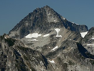
Mount Redoubt is a mountain in the North Cascades range in Whatcom County, Washington state. The peak is located 3.0 miles (5 km) from the Canada–US border, 16.3 miles (26 km) east-northeast of Mount Shuksan. It is the 21st highest peak in the state, with a height of 8,956 feet (2,730 m) and a prominence of 1,649 feet (503 m). Redoubt is in the Skagit Range, a sub-range of the North Cascades, in the Custer-Chilliwack Group which includes Mount Spickard, Mount Redoubt, Mount Custer and Mox Peaks, among others. Redoubt, Bear, and Depot creeks drain off the mountain, which is composed of Skagit gneiss. Mount Redoubt is listed as one of the "Classic Eight Peaks" in the North Cascades.

Cosho Peak is in North Cascades National Park in the U.S. state of Washington. Cosho Peak is a summit along a ridge known as Ragged Ridge and the Kimtah Glacier is on the northeast slopes of the peak.
Kimtah Peak, elevation 8,600+ feet, is in North Cascades National Park in the U.S. state of Washington. Kimtah Peak is a summit along a ridge known as Ragged Ridge. Kimtah Glacier is on the northwest slopes of the peak, while Katsuk Glacier is to the northeast.
Custer Ridge (Mount Custer) (8,630 feet (2,630 m)) is a ridge in North Cascades National Park in the U.S. state of Washington. Located in the northern section of the park, Custer Ridge rises to the west of Silver Lake, 1.4 mi (2.3 km) north-northwest of Mount Spickard. The high point along Custer Ridge is a peak tentatively named Mount Custer, which lies near the southwestern end of the ridge. Custer Ridge extends beyond the Canada–US border.

Mox Peaks is in North Cascades National Park in the U.S. state of Washington. Located in the northern section of the park, Mox Peaks consist of several summits in close proximity to each other that are nearly the same altitude, but the highest point is the eastern peak. Mox Peaks West looms just to the southeast of Redoubt Glacier and is at the southern terminus of a long arête which extends 1.75 mi (2.82 km) to Mount Spickard to the northeast. A deep col lies between Mox Peaks High Point and Mox Peaks West.

Fortress Mountain is a 8,671-foot (2,643 m) peak in the Cascade Range located about 15 miles (24 km) west of Lake Chelan in Chelan/Snohomish Counties, Washington, United States. It straddles the border between the Mount Baker-Snoqualmie National Forest and the Wenatchee National Forest, and is also part of the Glacier Peak Wilderness. Fortress Mountain is the highest point on Chiwawa Ridge, and other notable peaks on this ridge include Napeequa Peak, Buck Mountain, Brahma Peak, Bandit Peak, Mount Berge, Helmet Butte, and Chiwawa Mountain.

White Chuck Mountain, or native name Hi Khaed, is a 6,989 ft (2,130 m) summit near the western edge of the North Cascades, in Snohomish County of Washington state. It is located southeast of Darrington, Washington, east of the Mountain Loop Highway, and northwest of Glacier Peak which is one of the Cascade stratovolcanoes. It is situated at the confluence of the White Chuck River and the Sauk River on land administered by the Mount Baker-Snoqualmie National Forest. The mountain is named for the White Chuck River, which "chuck" in Chinook Jargon means "water". The nearest higher neighbor is Mount Pugh, 4.9 miles (7.9 km) to the south-southeast.

Ruth Mountain is a 7,115 ft (2,170 m) Skagit Range summit located two miles south of Hannegan Pass in the North Cascades of Washington state. The name honors Ruth Cleveland, daughter of President Grover Cleveland. This mountain's name was officially adopted in 1952 by the United States Board on Geographic Names. Ruth Mountain is situated on the shared border of North Cascades National Park and the Mount Baker Wilderness, which is part of the Mount Baker-Snoqualmie National Forest. The summit offers views of Mount Shuksan, East Nooksack Glacier, Seahpo Peak, Nooksack Tower, Icy Peak, Mount Sefrit, Mineral Mountain, and the Picket Range. The melting and receding Ruth Glacier on the north slope of Ruth creates the headwaters for the Chilliwack River. Precipitation runoff also finds its way into the Nooksack and Baker Rivers.

Icy Peak is a 7,073-foot (2,156-metre) Skagit Range mountain summit located in the North Cascades of Washington state. It is situated in North Cascades National Park at the head of Nooksack Cirque. High ridges connect it to Seahpo Peak and Mount Shuksan. An icefall occupies the northeast cirque, and small glaciers clad all sides of the peak. Precipitation runoff drains into the Nooksack and Baker Rivers.
Sheep Mountain is a 6,166-foot-elevation (1,879-meter) summit near the western edge of the North Cascades, in Snohomish County of Washington state. It is located one mile east of Barlow Pass along the Mountain Loop Highway near the Monte Cristo area. It is situated on land administered by the Mount Baker-Snoqualmie National Forest. Back in the old mining days of the late 1800s, the long sub-range stretching from Cadet Peak to Sheep Mountain was known as Pride of the Mountains Range. Precipitation runoff from the mountain drains into tributaries of the Sauk River.

Mount Sefrit is a 7,191 ft (2,190 m) Skagit Range summit located three miles north of Mount Shuksan in the North Cascades of Washington state. It is situated in the Mount Baker Wilderness, which is managed by the Mount Baker-Snoqualmie National Forest. The summit offers views of Mount Shuksan, Mount Baker, and the Picket Range. Mount Sefrit's name honors Frank Ira Sefrit (1867–1950), editor and publisher of The Bellingham Herald for nearly 40 years. This mountain's name was officially adopted in 1952 by the U.S. Board on Geographic Names. Precipitation runoff from the mountain drains into the deep valleys of Ruth Creek and the Nooksack River which nearly encircle Mount Sefrit, except for Nooksack Ridge which connects it to Ruth Mountain.

Table Mountain is a Skagit Range summit located west of Mount Shuksan and northeast of Mount Baker in the North Cascades of Washington state. It is situated in the Mount Baker Wilderness, which is managed by the Mount Baker-Snoqualmie National Forest. Table Mountain is located west of Artist Point, at the end of the Mount Baker Highway. From the Artist Point parking lot, a short 1.4 mile trail leads to the summit at the west end of the mountain. The summit offers views of Mount Shuksan, Mount Baker, Mount Hermann, and Mount Larrabee. Remnants of the Table Mountain Glacier are on the northeast slope. Precipitation runoff from the mountain drains into tributaries of the Skagit and Nooksack Rivers.

Round Mountain is a 5,320+ ft mountain summit at the western edge of the North Cascades, in Skagit County of Washington state. It is located nine miles northwest of Darrington, Washington and is situated on land administered by the Mount Baker-Snoqualmie National Forest. Round Mountain is remarkable for its 4,780 feet of prominence which ranks as the most in Skagit County, and eighth most of all the mountains in Washington state. The nearest higher peak is Whitehorse Mountain, 7.85 miles (12.63 km) to the south-southeast. Precipitation runoff from Round Mountain drains into tributaries of the Stillaguamish River.

Mount Ballard is an 8,340-foot (2,540-metre) mountain summit located in eastern Whatcom County in Washington state. It is part of the Okanogan Range which is a sub-range of the North Cascades Range, and the mountain is situated on land administered by the Okanogan–Wenatchee National Forest. Ballard ranks 88th on Washington's highest 100 peaks. The nearest higher neighbor is Azurite Peak, 2.04 miles (3.28 km) to the south. Precipitation runoff from Mount Ballard drains into Mill Creek and Slate Creek, both tributaries of the Skagit River.

Granite Mountain is a 6,692-foot (2,040-metre) mountain summit located in the Skagit Range, which is a subset of the North Cascades in Whatcom County of Washington state. It is situated 1.7 mi (2.7 km) south of Mount Chardonnay, and 1.2 mi (1.9 km) northwest of Hannegan Peak in the Mount Baker Wilderness, which is managed by the Mount Baker-Snoqualmie National Forest. Precipitation runoff from the mountain drains into tributaries of the Fraser River and the Nooksack River.

Hannegan Peak is a 6,191-foot elevation (1,887 m) mountain summit located in the Skagit Range, which is a subset of the North Cascades in Whatcom County of Washington state. It is situated immediately north of Hannegan Pass, and 2.2 mi (3.5 km) north of Ruth Mountain in the Mount Baker Wilderness, which is managed by Mount Baker-Snoqualmie National Forest. Banning Austin and R.M. Lyle made the first ascent of Hannegan Peak in 1893 while surveying for a possible road across the Cascades over Hannegan Pass to Whatcom Pass. This peak was named in association with Hannegan Pass, which in turn was named for Tom Hannegan, State Road Commissioner at that time. Although no road was built, a four-mile trail leads hikers to the pass, and another one-mile path leads to the summit. Peaks which can be seen from the summit include Mount Shuksan, Ruth Mountain, Mineral Mountain, Mount Baker, Mount Sefrit, Mount Larrabee, Granite Mountain, Mount Chardonnay, Mount Rexford, the Picket Range, and many more.

Brahma Peak is a remote 8,078-foot (2,462-metre) mountain summit located on Chiwawa Ridge in the North Cascades, in Chelan County of Washington state. The mountain is situated in the Glacier Peak Wilderness, on land managed by the Wenatchee National Forest. Its nearest higher neighbor is Buck Mountain, 1.8 mi (2.9 km) to the north. Brahma and Buck are set on Chiwawa Ridge, and other notable peaks on this ridge include Fortress Mountain, Cirque Mountain, Napeequa Peak, Mount Berge, Bandit Peak, and Chiwawa Mountain. Precipitation runoff from Brahma and meltwater from its glacier remnants drains into Chiwawa River and Napeequa River, both tributaries of the Wenatchee River. Topographic relief is significant since the southwest lavender-colored schist cliffs of this peak rise nearly 4,000 feet above the Napeequa River Valley in approximately one mile.

Cirque Mountain is a 7,966-foot (2,428-metre) mountain summit located in the Glacier Peak Wilderness of the North Cascades in Washington state. The mountain is situated on the crest of the Cascade Range, on the shared border of Snohomish County and Chelan County, also straddling the boundary between the Mount Baker-Snoqualmie National Forest and the Wenatchee National Forest. Its nearest higher peak is Napeequa Peak, 0.3 mi (0.48 km) to the south. The peak is set on Chiwawa Ridge with Napeequa, and other notable peaks on this ridge include Fortress Mountain, Buck Mountain, Brahma Peak, Mount Berge, and Chiwawa Mountain. Topographic relief is significant since the western aspect of the mountain rises 4,000 feet above the Suiattle Valley in approximately 1.5 mi (2.4 km). This mountain has small, unnamed, hanging glaciers in cirques surrounding the summit. Precipitation runoff from the peak and meltwater from the glaciers drains east to the headwaters of Napeequa River; or west into the Suiattle River.
Easy Peak is a 6,613-foot (2,016-metre) mountain summit in the Skagit Range of the North Cascades, in Whatcom County of Washington state. Easy Peak is situated in North Cascades National Park, and is often climbed during the Easy Ridge approach to Mount Challenger and the remote northern Pickets. Its nearest higher neighbor is Mineral Mountain, 2 mi (3.2 km) to the west, and Whatcom Peak is set 2.1 mi (3.4 km) to the east. Glacierets line the north slope of Easy Ridge between Easy Peak and Whatcom Peak. Precipitation runoff from this peak drains north into the Chilliwack River, or south into headwaters of the Baker River.


