Mount Allenby is a mountain summit in Alberta, Canada.

Mount Byng is a 2,965-metre (9,728-foot) mountain summit located in the upper Spray River Valley of southern Banff National Park, in the Canadian Rockies of Alberta, Canada. It is the second-highest point in the Blue Range. Mount Byng's nearest higher peak is Mount Alcantara, 6.5 km (4.0 mi) to the west-southwest. The mighty Mount Assiniboine is situated 10.0 km (6.2 mi) to the northwest of Byng.

Elpoca Mountain is a 3,036-metre (9,961-foot) mountain summit located at the southern end of the Opal Range in the Canadian Rockies of Alberta, Canada. The nearest higher peak is Mount Evan-Thomas, 12.0 km (7.5 mi) to the north. Elpoca Mountain is situated 4.0 kilometres south of Mount Jerram, and 2.0 km east of Gap Mountain, and all are within Peter Lougheed Provincial Park. Precipitation runoff from the west side of the mountain drains into tributaries of the Kananaskis River, whereas the east side drains into Elbow River.

The Monarch is a 2,895-metre (9,498-foot) mountain summit located in the Ball Range of the Canadian Rockies in British Columbia, Canada. The Monarch is situated on the boundary between Kootenay National Park and Mount Assiniboine Provincial Park, four kilometres to the west side of the Continental Divide. Although not visible from roads, The Monarch is a prominent feature seen from the slopes above Sunshine Village ski resort. Its nearest higher peak is Mount Bourgeau, 10.35 km (6.43 mi) to the north-northeast.

Wedgwood Peak is a 3,024-metre (9,921-foot) mountain summit located in Mount Assiniboine Provincial Park, in the Canadian Rockies of British Columbia, Canada. Its nearest higher peak is Mount Assiniboine, 2.0 km (1.2 mi) to the south. The mountain is situated northwest of Lake Magog and 1.0 km (0.62 mi) south of Sunburst Peaks.

The Marshall is a 3,180-metre (10,430-foot) mountain summit located in Mount Assiniboine Provincial Park, in the Canadian Rockies of British Columbia, Canada. Its nearest higher peak is Mount Assiniboine, 3.0 km (1.9 mi) to the east-southeast. The mountain is situated west of Wedgwood Peak.

Sunburst Peaks is a 2,849-metre (9,347-foot) mountain summit located in Mount Assiniboine Provincial Park, in the Canadian Rockies of British Columbia, Canada. Its nearest higher peak is Wedgwood Peak, 1.0 km (0.62 mi) to the south. The mountain is situated immediately southeast of Sunburst Lake, west of Lake Magog, and south of Cerulean Lake.
Mount Watson is a 2,955-metre (9,695-foot) mountain summit located in Mount Assiniboine Provincial Park, in the Canadian Rockies of British Columbia, Canada. The nearest higher peak is The Marshall, 2.0 km (1.2 mi) to the southeast.

Naiset Point is a 2,755-metre (9,039-foot) mountain summit located in Mount Assiniboine Provincial Park, in the Canadian Rockies of British Columbia, Canada. The mountain is situated 1.0 km (0.62 mi) southeast of Lake Magog, and at the end of the ridge extending north from Terrapin Mountain. Naiset Point is composed of sedimentary rock laid down during the Cambrian period. Formed in shallow seas, this sedimentary rock was pushed east and over the top of younger rock during the Laramide orogeny.

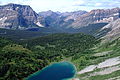
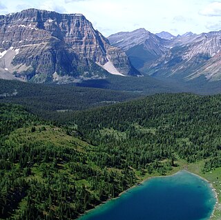
Mount Harkin is a 2,979-metre (9,774-foot) mountain summit located in the Kootenay River Valley along the eastern border of Kootenay National Park. Park visitors can see the peak from Highway 93, also known as the Banff–Windermere Highway. It is part of the Mitchell Range, which is a sub-range of the Canadian Rockies of British Columbia, Canada. Its nearest higher peak is Mount Assiniboine, 14.0 km (8.7 mi) to the northeast.

Nub Peak is a 2,746-metre (9,009-foot) mountain summit located in Mount Assiniboine Provincial Park, in the Canadian Rockies of British Columbia, Canada. Its nearest higher peak is Nestor Peak, 4.0 km (2.5 mi) to the west. The mountain is situated north of Sunburst Peaks, with Elizabeth Lake and Cerulean Lake in between. The Continental Divide and Assiniboine Pass are situated 3.5 km (2.2 mi) to the east. Nub Peak is famous for its panoramic view of Mount Assiniboine with its surrounding lakes and peaks. The mountain's descriptive name was officially adopted in 1924. An arm extending southwest from Nub is officially known as Chucks Ridge, and an arm extending southeast is officially called Nublet. Nub Peak is composed of sedimentary rock laid down during the Cambrian period and pushed east over the top of younger rock during the Laramide orogeny.

St. Julien Mountain is a 3,090-metre (10,138 ft) mountain summit located in the Canadian Rockies of British Columbia, Canada. It is situated on the British Columbia-Alberta border, as well as the Continental Divide, and the west boundary of Banff National Park. Neighbors include Mount Forbes 6.4 km (4.0 mi) to the east-northeast, Valenciennes Mountain 2.8 km (1.7 mi) to the south, and Icefall Peak is 12 km (7.5 mi) to the west.

Mount Alcantara is a 3,029-metre (9,938-foot) mountain summit located in British Columbia, Canada.

Mount Anne-Alice is a mountain summit in the Canadian Rockies of British Columbia, Canada.

Nestor Peak is a 2,972-metre (9,751-foot) mountain summit located in Mount Assiniboine Provincial Park of British Columbia, Canada.

Indian Peak is a 2,992-metre (9,816-foot) mountain summit located in Mount Assiniboine Provincial Park of British Columbia, Canada.

Mount Shanks is a 2,838-metre (9,311-foot) mountain summit located in British Columbia, Canada.

Octopus Mountain is a 2,932-metre (9,619-foot) mountain summit located in Mount Assiniboine Provincial Park of British Columbia, Canada.

Mount Swiderski is a 3,133-metre (10,279-foot) mountain summit in British Columbia, Canada.

Mount Battisti is a 3,155-metre (10,351-foot) mountain summit in British Columbia, Canada.