Mount Byng is a 2,965-metre (9,728-foot) mountain summit located in the upper Spray River Valley of southern Banff National Park, in the Canadian Rockies of Alberta, Canada. It is the second-highest point in the Blue Range. Mount Byng's nearest higher peak is Mount Alcantara, 6.5 km (4.0 mi) to the west-southwest. The mighty Mount Assiniboine is situated 10.0 km (6.2 mi) to the northwest of Byng.

The Monarch is a 2,895-metre (9,498-foot) mountain summit located in the Ball Range of the Canadian Rockies in British Columbia, Canada. The Monarch is situated on the boundary between Kootenay National Park and Mount Assiniboine Provincial Park, four kilometres to the west side of the Continental Divide. Although not visible from roads, The Monarch is a prominent feature seen from the slopes above Sunshine Village ski resort. Its nearest higher peak is Mount Bourgeau, 10.35 km (6.43 mi) to the north-northeast.

Wedgwood Peak is a 3,024-metre (9,921-foot) mountain summit located in Mount Assiniboine Provincial Park, in the Canadian Rockies of British Columbia, Canada. Its nearest higher peak is Mount Assiniboine, 2.0 km (1.2 mi) to the south. The mountain is situated northwest of Lake Magog and 1.0 km (0.62 mi) south of Sunburst Peaks.

The Marshall is a 3,180-metre (10,430-foot) mountain summit located in Mount Assiniboine Provincial Park, in the Canadian Rockies of British Columbia, Canada. Its nearest higher peak is Mount Assiniboine, 3.0 km (1.9 mi) to the east-southeast. The mountain is situated west of Wedgwood Peak.

Sunburst Peaks is a 2,849-metre (9,347-foot) mountain summit located in Mount Assiniboine Provincial Park, in the Canadian Rockies of British Columbia, Canada. Its nearest higher peak is Wedgwood Peak, 1.0 km (0.62 mi) to the south. The mountain is situated immediately southeast of Sunburst Lake, west of Lake Magog, and south of Cerulean Lake.
Mount Watson is a 2,955-metre (9,695-foot) mountain summit located in Mount Assiniboine Provincial Park, in the Canadian Rockies of British Columbia, Canada. The nearest higher peak is The Marshall, 2.0 km (1.2 mi) to the southeast.

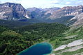
Mount Harkin is a 2,979-metre (9,774-foot) mountain summit located in the Kootenay River Valley along the eastern border of Kootenay National Park. Park visitors can see the peak from Highway 93, also known as the Banff–Windermere Highway. It is part of the Mitchell Range, which is a sub-range of the Canadian Rockies of British Columbia, Canada. Its nearest higher peak is Mount Assiniboine, 14.0 km (8.7 mi) to the northeast.

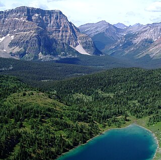
Nub Peak is a 2,746-metre (9,009-foot) mountain summit located in Mount Assiniboine Provincial Park, in the Canadian Rockies of British Columbia, Canada. Its nearest higher peak is Nestor Peak, 4.0 km (2.5 mi) to the west. The mountain is situated north of Sunburst Peaks, with Elizabeth Lake and Cerulean Lake in between. The Continental Divide and Assiniboine Pass are situated 3.5 km (2.2 mi) to the east. Nub Peak is famous for its panoramic view of Mount Assiniboine with its surrounding lakes and peaks. The mountain's descriptive name was officially adopted in 1924. An arm extending southwest from Nub is officially known as Chucks Ridge, and an arm extending southeast is officially called Nublet. Nub Peak is composed of sedimentary rock laid down during the Cambrian period and pushed east over the top of younger rock during the Laramide orogeny.

Pharaoh Peaks is a 2,713-metre (8,901-foot) mountain with three summits located in Banff National Park in Alberta, Canada. Pharaoh Peaks are part of the Ball Range in the Canadian Rockies. The nearest higher peak is Scarab Peak, 2.0 km (1.2 mi) to the southwest. The mountain's name Pharaoh was in keeping with the Egyptian theme of the immediate surrounding area, e.g., Egypt Lake, Pharaoh Lake, Mummy Lake, and Scarab Lake, which were applied in 1922 by Arthur O. Wheeler of the Interprovincial Boundary Survey. Wheeler regarded the area particularly beautiful when he wrote: "After 30 years of exploration, surveys and mapping the main ranges of the Canadian Rockies, the writer ... can safely say that outstanding among them for scenic charm and interest may be classed the group of peaks, lakes and alpine meadows of the Egypt Lake area." The mountain's name was officially adopted in 1956 when approved by the Geographical Names Board of Canada.
Mount McLaren is a 2,301-metre (7,549-foot) mountain summit located in Alberta, Canada.

Mount Mercer is a 2,970-metre (9,744-foot) mountain summit located in Alberta, Canada.

Mount Alcantara is a 3,029-metre (9,938-foot) mountain summit located in British Columbia, Canada.

Barbette Mountain is 3,072-metre (10,079-foot) summit located on the shared border of Alberta and British Columbia, Canada.

Mount Ogden is a mountain in the Canadian Rockies of British Columbia, Canada.

Nestor Peak is a 2,972-metre (9,751-foot) mountain summit located in Mount Assiniboine Provincial Park of British Columbia, Canada.

Mount Shanks is a 2,838-metre (9,311-foot) mountain summit located in British Columbia, Canada.

Octopus Mountain is a 2,932-metre (9,619-foot) mountain summit located in Mount Assiniboine Provincial Park of British Columbia, Canada.

Mount Sam is a 2,871-metre (9,419-foot) mountain summit located in Mount Assiniboine Provincial Park of British Columbia, Canada.

Mount Swiderski is a 3,133-metre (10,279-foot) mountain summit in British Columbia, Canada.

Mount Battisti is a 3,155-metre (10,351-foot) mountain summit in British Columbia, Canada.