Related Research Articles

Garrett County is the westernmost county of the U.S. state of Maryland. As of the 2020 census, the population was 28,806, making it the third-least populous county in Maryland. Its county seat is Oakland. The county was named for John Work Garrett (1820–1884), president of the Baltimore and Ohio Railroad. Created from Allegany County, Maryland in 1872, it was the last Maryland county to be formed.

Youngsville is a borough in Warren County, Pennsylvania, United States. The population was 1,729 at the 2010 census.
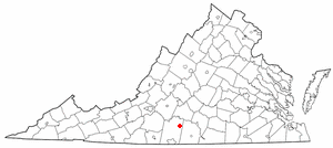
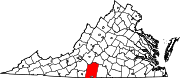
Mount Airy is an unincorporated community in northeastern Pittsylvania County, Virginia, United States. Its altitude is 643 feet (196 m), and it is located at 36°56′35″N79°11′32″W, along State Route 40 between Gretna and Brookneal. It is included in the Danville, Virginia Metropolitan Statistical Area.

Black Mountain is the highest mountain peak in the Commonwealth of Kentucky, United States, with a summit elevation of 4,145 feet (1,263 m) above mean sea level and a top-to-bottom height of over 2,500 feet (760 m). The summit is located at approximately 36°54′51″N82°53′38″W in Harlan County, Kentucky near the Virginia border, just above the towns of Lynch, Kentucky and Appalachia, Virginia. It is alternatively known as Katahrin's Mountain, and is about 500 feet (150 m) taller than any other mountain in Kentucky.
Lunice Creek is a 7.3-mile-long (11.7 km) tributary of the South Branch Potomac River, belonging to the Potomac River and Chesapeake Bay watersheds. The creek is located in Grant County, West Virginia. Lunice Creek is created by its North and South Forks and empties into the South Branch at Petersburg.
Mouth of Wilson is an unincorporated community, in Grayson County in the U.S. state of Virginia, just north of the North Carolina state line. The community lies in the Blue Ridge Highlands section of the Blue Ridge Mountains which are part of what is considered the 'Middle Appalachian Mountains' on the western banks of the New River, where the Big Wilson Creek empties its waters. The main road through the area is U.S. Route 58; other major roads include Virginia Route 16 and Virginia Route 93.
Sharon is an unincorporated community and coal town in southeastern Kanawha County, West Virginia, United States, located along the West Virginia Turnpike.
Oldrag is an unincorporated community located in Madison County, Virginia, on Old Rag Mountain.
Turkeycock Mountain is a mountain summit located in Franklin County, Virginia and Henry County, Virginia. Rising out of the eastern foothills of the Blue Ridge Mountains, Turkeycock Mountain rises to 1,657 feet (505 m) above sea level and is located at 36°49′45″N79°41′13″W. A portion of the mountain is protected as the Turkeycock Wildlife Management Area, which is open to the public.
Ski Mont Saint-Bruno is a Canadian alpine ski facility. It is located on the slopes of Mont Saint-Bruno, in the city of Saint-Bruno-de-Montarville, Quebec. It is located right next to Parc national du Mont-Saint-Bruno, a Quebec provincial park that offers cross-country skiing and snowshoeing. The ski station is located on the South Shore of Montreal, 30 minutes from Downtown Montreal. The ski hill is 175m tall. It is also next to a quarry.
The Nelson Range is a mountain range in the "Northern Mojave-Mono Lake region" of Inyo County, California, in Death Valley National Park.
Brosville is an unincorporated community in Pittsylvania County, in the U.S. state of Virginia.
Callahans Hills is an unincorporated community in Pittsylvania County, in the U.S. state of Virginia.
Cedar Hill is an unincorporated community in Pittsylvania County, in the U.S. state of Virginia.
Coles Hill is an unincorporated community in Pittsylvania County, in the U.S. state of Virginia. It is the site of the largest uranium deposit in the U.S.; however a 1982 Virginia ban on uranium mining has kept its resources from being used commercially. The lode is the subject of an ongoing controversy about possible extraction. Lower courts ruled in favor of the state's ban, however in October 2018 the case was scheduled to be heard by the Supreme Court. The Supreme Court upheld Virginia's ban on uranium mining in Virginia Uranium, Inc. v. Warren.
Flint Hill, Pittsylvania County is an unincorporated community in Pittsylvania County, in the U.S. state of Virginia.
Oak Hill is an unincorporated community in Pittsylvania County, in the U.S. state of Virginia.
Pittsville is an unincorporated community in Pittsylvania County, in the U.S. state of Virginia.

Chestnut Ridge is the westernmost ridge of the Allegheny Mountains in Pennsylvania, United States. It is located primarily within the Laurel Highlands region of southwestern Pennsylvania, extending into northern West Virginia.
Gwaenysgor is a small village in Flintshire, Wales. Located near Prestatyn in north Wales, it lies at an elevation of 600 feet, 183 metres. There is one pub, the Eagle and Child. The remnants of RAF Prestatyn lie on the hill nearby..
References
36°33′25″N79°19′07″W / 36.55694°N 79.31861°W
| | This Pittsylvania County, Virginia state location article is a stub. You can help Wikipedia by expanding it. |