
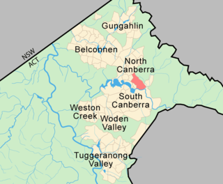
The Australian Capital Territory, formerly known as the Federal Capital Territory until 1938 and commonly referred to as the ACT, is a federal territory of Australia containing the Australian capital city of Canberra and some surrounding townships. It is located in the south-east of the country and is an enclave within the state of New South Wales. Founded after Federation as the seat of government for the new nation, all important institutions of the Australian federal government are centred in the territory.

Namadgi National Park is a protected area in the south-west of the Australian Capital Territory, bordering Kosciuszko National Park in New South Wales. It lies approximately 40 kilometres (25 mi) southwest of Canberra, and makes up approximately 46% of the ACT's land area.
The Australian Capital Territory as of 2014 contains 46 separate protected areas with a total land area of 1,302 km2 (503 sq mi) or 55.5% of the territory's area, and which managed by Territory and Municipal Services of the ACT government:

Tidbinbilla Nature Reserve is a 54.5 square kilometres (21.0 sq mi) protected area, on the fringe of Namadgi National Park. Tidbinbilla is a short drive from the capital city of Australia, Canberra, in the Australian Capital Territory. It is the traditional Country of the Ngunnawal people.

Acton is a suburb of Canberra, ACT, Australia. Acton covers an area west of the CBD, bordered by Black Mountain to the west and Lake Burley Griffin in the south. The Australian National University campus covers most of the suburb, though also located in Acton is the National Film and Sound Archive, a branch of the CSIRO and the National Museum of Australia.
Campbell is a suburb of Canberra, Australian Capital Territory, Australia. Covering an area to the South East of the central business district, Campbell sits at the base of Mount Ainslie and is bounded to the south east by the Mount Pleasant Nature Reserve. At the 2016 census, Campbell had a population of 4,997 people.

O'Connor is an affluent suburb of Canberra, Australia in the North Canberra district characterised by its leafy, heritage listed streets. It was named after Richard Edward O'Connor (1851–1912), who was a judge in the High Court and a founder of the Australian constitution. Street names in O'Connor are named after explorers, Australian flora, legislators and pioneers. The suburb name was gazetted on 20 September 1928.

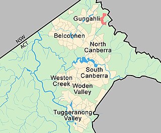
Bonner is a suburb in the district of Gungahlin in Canberra in Australia. The suburb is named in memory after Senator Neville Bonner, Australia's first Indigenous parliamentarian who served the people of Queensland during the years 1971-1984. The suburb is bounded by Horse Park Drive, Mulligans Flat Road, and Roden Cutler Drive and is approximately 4 km (2.5 mi) from the Gungahlin Town Centre and 16 km (9.9 mi) from the centre of Canberra. It is adjacent to the suburbs of Jacka, Amaroo and Forde. Settlement of the suburb began in 2010 and it had an estimated population of 6,730 at the 2016 census.

Forde is a northern suburb of the Canberra, Australia district of Gungahlin. It is named in honour of Frank Forde, who served as Prime Minister of Australia for a week in 1945 following the untimely death of John Curtin. The suburb abuts the Mulligans Flat Reserve and is adjacent to the suburbs of Amaroo, Throsby and Bonner. The suburb is bound to the south and west respectively by Horse Park Drive and Gundaroo Road. Settlement of the suburb began in 2008 and it had an estimated population of 4,308 at the 2016 census.
Throsby is a designated suburb of Canberra, Australia in the district of Gungahlin. The suburb is adjacent to the suburbs of Kenny and Harrison and is bounded by the Federal Highway to the east, the ACT/NSW border to the north, Horse Park Drive to the south and the Goorooyarroo nature reserve to the west. The suburb is named after the explorer Charles Throsby who was one of the first Europeans to open up the lands west of the Blue Mountains to grazing and agriculture.
The history of the Australian Capital Territory (ACT) as a separate administrative division began in 1911, when it was transferred from New South Wales to the Australian federal government. The territory contains Australia's capital city Canberra and various smaller settlements. Until 1989, it also administered the Jervis Bay Territory, a small coastal region.

Wongalara Sanctuary is a nature reserve in the Top End of the Northern Territory of Australia.

Corroboree Park is in Ainslie, ACT, Canberra, Australia. It is shaped like a semicircle, and is associated with the Aboriginal use of the area prior to European settlement in Canberra. The park was created around 1925 around the 'Corroboree Tree' located in the park. It is in a heritage registered area, and is also a registered heritage park.

Ginninderra Creek, a partly perennial stream of the Murrumbidgee catchment within the Murray-Darling basin, is located in the Capital Country region spanning both the Australian Capital Territory and New South Wales, Australia.

An Indigenous Protected Area (IPA) is a class of protected area used in Australia; each is formed by agreement with Indigenous Australians, and declared by Indigenous Australians. Each is formally recognised by the Australian Government as being part of its National Reserve System, with 75 IPAs comprising more than 44% of the national reserve land, occupying about 67,000,000 hectares as of April 2020.
Jerrabomberra Creek, a partly perennial stream of the Murrumbidgee catchment within the Murray-Darling basin, is located in the Capital Country region spanning both New South Wales and the Australian Capital Territory, Australia.

The Paroo-Darling National Park is a protected national park that is located in the Far West region of New South Wales, in eastern Australia. The 178,053-hectare (439,980-acre) national park spans two distinct regions in the outback area. This region covers the arid catchments of the Paroo River and the Paroo-Darling confluence to the south.
Oakey Hill is a hill near Canberra, Australian Capital Territory. It rises 80 metres above the adjacent south Canberra suburbs of Lyons, Curtin and Weston, and its 66 hectares is one of 33 areas which form Canberra Nature Reserve. The highest point of the hill, 684 metres above sea level, is marked by a survey station.

Gibraltar Creek, a perennial stream that is part of the Murrumbidgee catchment within the Murray-Darling basin, is located in the Australian Capital Territory, Australia.

The Queanbeyan Nature Reserve is a protected nature reserve that is located in the Southern Tablelands region of New South Wales, in eastern Australia. The 67-hectare (170-acre) reserve is situated approximately 4 kilometres (2.5 mi) west-south-west of the City of Queanbeyan.

