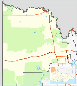
The Rural City of Mildura is a local government area in Victoria, Australia, located in the north-western part of the state. It covers an area of 22,083 square kilometres (8,526 sq mi) being the largest LGA in the state. In August 2021 the area had a population of 56,972. It includes the city of Mildura and the towns of Merbein, Red Cliffs, Irymple, Ouyen, Werrimull, Murrayville, Walpeup and Hattah. It was formed in 1995 from the amalgamation of the City of Mildura, Shire of Mildura and Shire of Walpeup.

Lake Albert, also known by its Ngarrindjeri name, Yarli, is a notionally fresh water lake near the mouth of the Murray River in South Australia. It is filled by water flowing in from the larger Lake Alexandrina at its mouth near Narrung. It is separated on the south by the Narrung Peninsula from the salt-water Coorong. The only major town on the lake is Meningie. Lakes Alexandrina and Albert are together known as the Lower Lakes.
Donovans is a locality in the Australian state of South Australia located in the state's south-east on the Glenelg River adjoining the border with the state of Victoria. It is about 403 kilometres south-east of the state capital of Adelaide and 26 kilometres south-east of the centre of the city of Mount Gambier.
Wye is a locality in the Australian state of South Australia located on the state's south-east coast adjoining the border with the state of Victoria and overlooking Discovery Bay in the body of water known in Australia as the Southern Ocean and by international authorities as the Great Australian Bight. It is about 399 kilometres south-east of the state capital of Adelaide and 22 kilometres south-east of the city centre of Mount Gambier.
Bellmere is a rural locality in the City of Moreton Bay, Queensland, Australia. In the 2021 census, Bellmere had a population of 6,588 people.
Lindsay Point is a locality in northwestern Victoria, Australia, located approximately 130 km from Mildura. Its northern extremity, located at 33.981°S 140.963°E, is less than one kilometre from the South Australian town of Murtho and is notable for being the only location in Victoria that lies to the west of a portion of the state of South Australia.

Woolooga is a rural town and locality in the Gympie Region, Queensland, Australia. In the 2021 census, the locality of Woolooga had a population of 310 people.
Glenburnie is an eastern suburb of Mount Gambier.

Burdett is a locality in South Australia located on the eastern side of the Murray River about 3.5 kilometres to the east of the city of Murray Bridge and about 74 kilometres east south-east of the Adelaide city centre. Its name is derived from the Hundred of Burdett.

East Trinity is a coastal rural locality in the Cairns Region, Queensland, Australia. It was formerly known as Trinity East. In the 2021 census, East Trinity had a population of 238 people.
Brownlow is a locality in the Australian state of South Australia about 98 kilometres north-east of the Adelaide city centre
Goolwa North is a locality in the Australian state of South Australia located about 66 kilometres south of the state capital of Adelaide and 2.5 kilometres northeast of the centre of the municipal seat of Goolwa overlooking the following water bodies in the Murray River system - Currency Creek to the north and the channel known as Goolwa or the Lower Murray to the south-east.
Tolderol is a locality in the Australian state of South Australia located about 67 kilometres south of the Adelaide city centre, 32 kilometres north-east of the centre of Goolwa and 32 kilometres south-west of the centre of Murray Bridge on the west coastline of Lake Alexandrina.
Big Desert is a locality in the Australian state of Victoria located in the state's west adjoining the border with South Australia within the local government areas of the Shire of Hindmarsh, the Rural City of Mildura and the Shire of West Wimmera. The principal land use is conservation with part of the locality being occupied by the following protected areas:
Little Desert is a locality in the Australian state of Victoria located about 333 kilometres (207 mi) north-west of the state capital of Melbourne and about 17 kilometres (11 mi) south of the municipal seat of Nhill. At the 2016 census, Little Desert had a population of 5. The locality's name and extent was registered on 23 July 1998. The principal land use is conservation with the majority of the locality being occupied by the Little Desert National Park.
Caroline is a locality in the Australian state of South Australia located about 389 kilometres (242 mi) south-east of the state capital of Adelaide and about 12 kilometres (7.5 mi) southeast of the municipal seat of Mount Gambier adjoining the border with the state of Victoria.
Mingbool is a locality in the Australian state of South Australia located about 372 kilometres (231 mi) south-east of the state capital of Adelaide adjoining the border with the state of Victoria and about 16 kilometres (9.9 mi) north-west of the municipal seat of Mount Gambier.
Fisher is a locality in the Australian state of South Australia located about 96 kilometres (60 mi) north-east of the state capital of Adelaide and about 47 kilometres (29 mi) north-east of the municipal seat in Mannum.
Glendale is a rural locality in the Shire of Livingstone, Queensland, Australia. In the 2021 census, Glendale had a population of 600 people.
Gurindji is a locality in the Northern Territory of Australia located about 459 kilometres (285 mi) south of the territory capital of Darwin.