NUTS statistical regions of the Republic of Ireland

Last updated

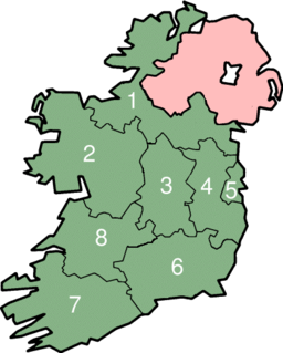
The Nomenclature of Territorial Units for Statistics (NUTS) is a geocode standard for referencing the subdivisions of Ireland for statistical purposes. [1] The standard is developed and regulated by the European Union. [2] The NUTS standard is instrumental in delivering the European Union's Structural Funds. The NUTS code for Ireland is IE and a hierarchy of three levels is established by Eurostat. Below these is a further levels of geographic organisation - the local administrative unit (LAU). In Ireland, the LAUs are electoral divisions.

Standardization or standardisation is the process of implementing and developing technical standards based on the consensus of different parties that include firms, users, interest groups, standards organizations and governments Standardization can help to maximize compatibility, interoperability, safety, repeatability, or quality. It can also facilitate commoditization of formerly custom processes. In social sciences, including economics, the idea of standardization is close to the solution for a coordination problem, a situation in which all parties can realize mutual gains, but only by making mutually consistent decisions. This view includes the case of "spontaneous standardization processes", to produce de facto standards.

Republic of Ireland Ireland, a country in north-western Europe, occupying 5/6 of the island of Ireland; succeeded the Irish Free State (1937)

Ireland, also known as the Republic of Ireland, is a country in north-western Europe occupying 26 of 32 counties of the island of Ireland. The capital and largest city is Dublin, which is located on the eastern side of the island. Around a third of the country's population of 4.8 million people resides in the greater Dublin area. The sovereign state shares its only land border with Northern Ireland, a part of the United Kingdom. It is otherwise surrounded by the Atlantic Ocean, with the Celtic Sea to the south, St George's Channel to the south-east, and the Irish Sea to the east. It is a unitary, parliamentary republic. The legislature, the Oireachtas, consists of a lower house, Dáil Éireann, an upper house, Seanad Éireann, and an elected President who serves as the largely ceremonial head of state, but with some important powers and duties. The head of government is the Taoiseach, who is elected by the Dáil and appointed by the President; the Taoiseach in turn appoints other government ministers.

European Union Economic and political union of European states

The European Union (EU) is a political and economic union of 28 member states that are located primarily in Europe. It has an area of 4,475,757 km2 (1,728,099 sq mi) and an estimated population of about 513 million. The EU has developed an internal single market through a standardised system of laws that apply in all member states in those matters, and only those matters, where members have agreed to act as one. EU policies aim to ensure the free movement of people, goods, services and capital within the internal market, enact legislation in justice and home affairs and maintain common policies on trade, agriculture, fisheries and regional development. For travel within the Schengen Area, passport controls have been abolished. A monetary union was established in 1999 and came into full force in 2002 and is composed of 19 EU member states which use the euro currency.

Contents

Overall

LevelSubdivisions
NUTS 1 1
NUTS 2 statistical regions3
NUTS 3 statistical regions8
Local administrative unite3,441

NUTS levels 1, 2 and 3

NUTS 1CodeNUTS 2CodeNUTS 3CodeLocal Government areas

Éire / Ireland
IE0Northern and WesternIE04 Border Region IE041 Cavan, Donegal, Leitrim, Monaghan, Sligo
West Region, Ireland IE042 Mayo, Roscommon, Galway and Galway City
SouthernIE05 Mid-West Region, Ireland IE051 Clare, Tipperary, Limerick City & County
South-East Region, Ireland IE052 Carlow, Kilkenny, Wexford, Waterford City & County
South-West Region, Ireland IE053 Kerry, Cork and Cork City
Eastern and MidlandIE06 Dublin Region IE061 Dublin City, Dún Laoghaire–Rathdown, Fingal and South Dublin
Mid-East Region, Ireland IE062 Kildare, Meath, Wicklow, Louth
Midlands Region, Ireland IE063 Laois, Longford, Offaly, Westmeath

Demographic statistics by NUTS 3 region

Regional AuthorityPopulation (2016)% of populationArea (km²)Population densityCapital(s)
Border394,3338.2811,515.6934.2 Sligo, Letterkenny,
Monaghan, Cavan
West453,1099.5214,289.1131.7 Galway
Mid-West473,2699.9410,511.4345.0 Limerick
South-East422,0628.867,198.0858.6 Waterford
South-West690,57514.5012,311.7356.1 Cork
Dublin1,347,35928.29925.911,455.2 Dublin
Mid-East688,85714.476,890.74100.0 Naas, Dundalk
Midlands292,3016.146,651.4343.9 Mullingar, Portlaoise
Ireland4,761,86510070,294.1367.7Dublin

Local administrative units

The local administrative units in Ireland are the electoral divisions. These are used for statistical purposes and for defining electoral boundaries, and have no local government function. [3]

Generally, a local administrative unit (LAU) is a low level administrative division of a country, ranked below a province, region, or state. Not all countries describe their locally governed areas this way, but it can be descriptively applied anywhere to refer to counties, municipalities, etc.

An electoral division is the smallest legally defined administrative areas in Ireland for which small area population statistics are published from the Census. There are a total of 3,440 electoral divisions in Ireland. They are used to define local electoral areas for elections to county and city councils and to define constituencies in elections to Dáil Éireann. Until 1994, they were known as district electoral divisions (DED) in the county council areas and wards in the five county boroughs which were then in existence. Electoral divisions are local administrative units within the NUTS system of the European Union.

Former regional authorities

Prior to 2014, there were 8 Regional Authorities in Ireland. They were abolished in 2014 and replaced by Regional Assemblies. [4] [5]

Regional Authorities in Ireland

Regional Authorities in Ireland were established by the Local Government Act 1991 and came into existence in 1994. Under this Act, the Regional Authorities had two main functions: to promote the co-ordination of public service provision and to monitor the delivery of European Union Structural Fund assistance in the regions. The Regional Authorities were dissolved in 2014 and were replaced by Regional Assemblies.

See also

ISO 3166-2:IE is the entry for Ireland in ISO 3166-2, part of the ISO 3166 standard published by the International Organization for Standardization (ISO), which defines codes for the names of the principal subdivisions of all countries coded in ISO 3166-1.

Local government in the Republic of Ireland

In Ireland, local government functions are mostly exercised by thirty-one local authorities, termed County, City, or City and County Councils. The principal decision-making body in each of the thirty-one local authorities is composed of the members of the council, elected by universal franchise in local elections every five years. Irish Local Authorities are the closest and most accessible form of Government to people in their local community. Many of the authorities' statutory functions are, however, the responsibility of ministerially appointed career officials termed Chief executives. The competencies of the city and county councils include planning, transport infrastructure, sanitary services, public safety and the provision of public libraries.

The Structural Funds and the Cohesion Fund are financial tools set up to implement the regional policy of the European Union. They aim to reduce regional disparities in income, wealth and opportunities. Europe's poorer regions receive most of the support, but all European regions are eligible for funding under the policy's various funds and programmes. The current Regional Policy framework is set for a period of seven years, from 2014 to 2020.

Sources

Related Research Articles

The Nomenclature of Territorial Units for Statistics is a geocode standard for referencing the subdivisions of countries for statistical purposes. The standard is developed and regulated by the European Union, and thus only covers the member states of the EU in detail. The Nomenclature of Territorial Units for Statistics is instrumental in the European Union's Structural Fund delivery mechanisms and for locating the area where goods and services subject to European public procurement legislation are to be delivered.

In the NUTS codes of Finland (FI), the three levels are:

In the NUTS codes of Denmark (DK), the three levels are:

In the NUTS codes of the Czech Republic (CZ), the three levels are:

NUTS statistical regions of the Netherlands

In the NUTS codes of the 'Netherlands (NL), the three levels are:

In the NUTS codes of Italy (IT), the three levels are:

In the NUTS codes of Spain (ES), the three levels are:

The NUTS codes of Hungary have three levels:

In the NUTS codes of France (FR), the three levels are:

First-level NUTS of the European Union

The Classification of Territorial Units for Statistics,, is a geocode standard for referencing the administrative divisions of countries for statistical purposes. The standard was developed by the European Union.

NUTS statistical regions of Switzerland

As a member of the EFTA, Switzerland (CH) is included in the Nomenclature of Territorial Units for Statistics (NUTS). The three NUTS levels are:

NUTS statistical regions of Greece

The NUTS codes of Greece are part of the Nomenclature of Territorial Units for Statistics, an official nomenclature of the European Commission used by Eurostat for statistical purposes.

In the NUTS codes of Malta (MT), the three levels are:

In the NUTS codes of Cyprus (CY), the three levels are:

In the NUTS codes of Luxembourg (LU), the three levels are:

As a member of the EFTA, Liechtenstein (LI) is included in the Nomenclature of Territorial Units for Statistics (NUTS). The three NUTS levels all correspond to the country itself:

NUTS statistical regions of Portugal

The Nomenclature of Territorial Units for Statistics (NUTS) is developed by Eurostat, and employed in Portugal for statistical purposes. The NUTS branch extends from NUTS1, NUTS2 and NUTS3 regions, with the complementary LAU sub-categorization being used to differentiate the local areas, of trans-national importance.

NUTS statistical regions of Turkey

As a candidate country of the European Union, Turkey (TR) is included in the Nomenclature of Territorial Units for Statistics (NUTS). Defined in 2002 in agreement between Eurostat and the Turkish authorities, Turkey's NUTS classifications are officially termed statistical regions, as Turkey is not a member of the EU and Eurostat only defines NUTS for member states. The three NUTS levels are:

NUTS 1 statistical regions of England

The Nomenclature of Territorial Units for Statistics (NUTS) is a geocode standard by Eurostat for referencing the subdivisions of the United Kingdom of Great Britain and Northern Ireland for statistical purposes. The NUTS code for the UK is UK and there are 12 first level regions within the State. As a country of the UK, there are 9 such regions in England. The standard is developed and regulated by the European Union (EU). The NUTS standard is instrumental in delivering the EU's Structural Funds. A hierarchy of three levels is established by Eurostat. The sub-structure corresponds to administrative divisions within the country. Formerly, the further NUTS divisions IV and V existed; these have now been replaced by Local Administrative Units . Between 1994 and 2011, the nine regions had an administrative role in the implementation of UK Government policy, and as the areas covered by elected bodies.

References

  1. "Revision to the Irish NUTS2 and NUTS3 regions". cso.ie.
  2. Commission Regulation (EU) 2016/2066 of 21 November 2016 amending the annexes to Regulation (EC) No 1059/2003 of the European Parliament and of the Council on the establishment of a common classification of territorial units for statistics (NUTS)
  3. "NATIONAL STRUCTURES (EU-28)". Eurostat . 30 November 2018. Retrieved 12 March 2018.
  4. "S.I. No. 228/2014 - Local Government Act 1991 (Regional Authorities) (Amendment) Order 2014". Irish Statute Book. 29 May 2014. Retrieved 24 March 2019.
  5. "S.I. No. 573/2014 - Local Government Act 1991 (Regional Assemblies) (Establishment) Order 2014". Irish Statute Book. 16 December 2014. Retrieved 24 March 2019.