![]() |
---|
![]() |
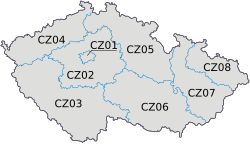
The Nomenclature of Territorial Units for Statistics (NUTS) is a geocode standard for referencing the subdivisions of the Czech Republic for statistical purposes. [1] The standard is developed and regulated by the European Union. [2] The NUTS standard is instrumental in delivering the European Union's Structural Funds. The NUTS code for the Czech Republic is CZ and a hierarchy of three levels is established by Eurostat. Below these is a further levels of geographic organisation - the local administrative unit (LAU). In the Czech Republic, the LAU 1 is districts and the LAU 2 is municipalities.
Level | Subdivisions | # |
---|---|---|
NUTS 1 | Whole Country | 1 |
NUTS 2 | Cohesion region (Region soudržnosti) | 8 |
NUTS 3 | Region (Kraj) | 14 |
NUTS 1 | Code | NUTS 2 | Code | NUTS 3 | Code |
---|---|---|---|---|---|
Czech Republic | CZ0 | Prague | CZ01 | Prague | CZ010 |
Střední Čechy (Central Bohemia) | CZ02 | Central Bohemian Region | CZ020 | ||
Jihozápad (Southwest) | CZ03 | South Bohemian Region | CZ031 | ||
Plzeň Region | CZ032 | ||||
Severozápad (Northwest) | CZ04 | Karlovy Vary Region | CZ041 | ||
Ústí nad Labem Region | CZ042 | ||||
Severovýchod (Northeast) | CZ05 | Liberec Region | CZ051 | ||
Hradec Králové Region | CZ052 | ||||
Pardubice Region | CZ053 | ||||
Jihovýchod (Southeast) | CZ06 | Vysočina Region | CZ063 | ||
South Moravian Region | CZ064 | ||||
Střední Morava (Central Moravia) | CZ07 | Olomouc Region | CZ071 | ||
Zlín Region | CZ072 | ||||
Moravskoslezsko (Moravian-Silesian) | CZ08 | Moravian-Silesian Region | CZ080 |
In the 2003 version, the Vysočina Region was coded CZ061, and the South Moravian Region was coded CZ062.
Below the NUTS levels, the two LAU (Local Administrative Units) levels are:
Level | Subdivisions | # |
---|---|---|
LAU 1 | Districts (Okresy) and Prague | 77 |
LAU 2 | Municipalities (Obce) | 6254 |