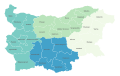
The Nomenclature of Territorial Units for Statistics (NUTS) is a geocode standard for referencing the subdivisions of Bulgaria for statistical purposes. [1] The standard is developed and regulated by the European Union. [2] The NUTS standard is instrumental in delivering the European Union's Structural Funds. The NUTS code for Bulgaria is BG and a hierarchy of three levels is established by Eurostat. Below these are a further level of the geographic organisation - the local administrative unit (LAU). In Bulgaria, the LAU 1 is municipalities and the LAU 2 is settlements.
Level | Subdivisions | # |
---|---|---|
NUTS 1 | Regions (Rayoni) | 2 |
NUTS 2 | Planning regions (Rayoni za planirane) | 6 |
NUTS 3 | Oblasts (Podregioni) | 28 |
Below the NUTS levels, the two LAU (Local Administrative Units) levels are:
Level | Subdivisions | # |
---|---|---|
LAU 1 | Municipalities (Obshtini) | 264 |
LAU 2 | Settlements (Naseleni mesta) | 5302 |
NUTS 1 | Code | NUTS 2 | Code | NUTS 3 | Code |
---|---|---|---|---|---|
Northern and Eastern Bulgaria | BG3 | Severozapaden (Northwestern) | BG31 | Vidin Province | BG311 |
Montana Province | BG312 | ||||
Vratsa Province | BG313 | ||||
Pleven Province | BG314 | ||||
Lovech Province | BG315 | ||||
Severen tsentralen (Northern Central) | BG32 | Veliko Tarnovo Province | BG321 | ||
Gabrovo Province | BG322 | ||||
Ruse Province | BG323 | ||||
Razgrad Province | BG324 | ||||
Silistra Province | BG325 | ||||
Severoiztochen (Northeastern) | BG33 | Varna Province | BG331 | ||
Dobrich Province | BG332 | ||||
Shumen Province | BG333 | ||||
Targovishte Province | BG334 | ||||
Yugoiztochen (Southeastern) | BG34 | Burgas Province | BG341 | ||
Sliven Province | BG342 | ||||
Yambol Province | BG343 | ||||
Stara Zagora Province | BG344 | ||||
South-Western and South-Central Bulgaria | BG4 | Yugozapaden (Southwestern) | BG41 | Sofia City | BG411 |
Sofia Province | BG412 | ||||
Blagoevgrad Province | BG413 | ||||
Pernik Province | BG414 | ||||
Kyustendil Province | BG415 | ||||
Yuzhen tsentralen (Southern Central) | BG42 | Plovdiv Province | BG421 | ||
Haskovo Province | BG422 | ||||
Pazardzhik Province | BG423 | ||||
Smolyan Province | BG424 | ||||
Kardzhali Province | BG425 | ||||
In the 2003 version, the codes were as follows:
Some of the present NUTS II regions of Bulgaria no longer meet the relevant technical requirements, mostly due to general population decline and increasing regional disproportion. A 2013 study by FLGR Consult commissioned by the Ministry of Regional Development and Public Works analyzed the state and trends of change in the characteristics of these regions to identify several options for the pending redrawing of the NUTS II map of the country. The process was restarted in 2017 with certain modified versions considered, and final decision due by the end of 2018. [3] [4] The relevant Regional Development (Amendment) Bill, released for public consultation by the Council of Ministers in October 2018, is based on a four-regions version chosen from the shortlist of three options developed by an inter-ministerial working group led by the Ministry of Regional Development and Public Works. [5]
Nomenclature of Territorial Units for Statistics or NUTS is a geocode standard for referencing the administrative divisions of countries for statistical purposes. The standard, adopted in 2003, is developed and regulated by the European Union, and thus only covers the EU member states in detail. The Nomenclature of Territorial Units for Statistics is instrumental in the European Union's Structural Funds and Cohesion Fund delivery mechanisms and for locating the area where goods and services subject to European public procurement legislation are to be delivered.
In the NUTS codes of Finland (FI), the three levels are:
The Nomenclature of Territorial Units for Statistics (NUTS) is a geocode standard for referencing the administrative division of Denmark for statistical purposes. The standard is developed and regulated by the European Union. The NUTS standard is instrumental in delivering the European Union's Structural Funds. The NUTS code for Denmark is DK and a hierarchy of three levels is established by Eurostat. Below these is a further levels of geographic organisation - the local administrative unit (LAU). In Denmark, the LAU 1 are municipalities and the LAU 2 are regions.
The Nomenclature of Territorial Units for Statistics (NUTS) is a geocode standard for referencing the subdivisions of the Czech Republic for statistical purposes. The standard is developed and regulated by the European Union. The NUTS standard is instrumental in delivering the European Union's Structural Funds. The NUTS code for the Czech Republic is CZ and a hierarchy of three levels is established by Eurostat. Below these is a further levels of geographic organisation - the local administrative unit (LAU). In the Czech Republic, the LAU 1 is districts and the LAU 2 is municipalities.
Ireland uses the Nomenclature of Territorial Units for Statistics (NUTS) geocode standard for referencing country subdivisions for statistical purposes. The standard is developed and regulated by the European Union. The NUTS standard is instrumental in delivering European Structural and Investment Funds. The NUTS code for Ireland is IE and a hierarchy of three levels is established by Eurostat. A further level of geographic organisation, the local administrative unit (LAU), in Ireland is the local electoral area.
In the NUTS codes of the Netherlands (NL), the three levels are:
In the NUTS codes of Italy (IT), the three levels are:
In the NUTS codes of Spain (ES), the following are the first-level political and administrative divisions.
The Nomenclature of Territorial Units for Statistics (NUTS) is a geocode standard for referencing the subdivisions of Belgium for statistical purposes. The standard is developed and regulated by the European Union. The NUTS standard is instrumental in delivering the European Union's Structural Funds. The NUTS code for Belgium is BE and a hierarchy of three levels is established by Eurostat. Below these is a further levels of geographic organisation - the local administrative unit (LAU). In Belgium, the LAUs are municipalities.
The Nomenclature of Territorial Units for Statistics (NUTS) is a geocode standard for referencing the subdivisions of Switzerland for statistical purposes. As a member of EFTA Switzerland is included in the NUTS standard, although the standard is developed and regulated by the European Union, an organization that Switzerland does not belong to. The NUTS standard is instrumental in delivering the European Union's Structural Funds. The NUTS code for Switzerland is CH and a hierarchy of three levels is established by Eurostat. Below these is a further levels of geographic organisation - the local administrative unit (LAU). In Switzerland, the LAUs are municipalities.
As a member of EFTA, Norway (NO) is not included in the Classification of Territorial Units for Statistics (NUTS), but in a similar classification used for coding statistical regions of countries that are not part of the EU but are candidate countries, potential candidates or EFTA countries. The three levels are:
The Nomenclature of Territorial Units for Statistics (NUTS) is a geocode standard for referencing the subdivisions of Germany for statistical purposes. The standard is developed and regulated by the European Union. The NUTS standard is instrumental in delivering the European Union's Structural Funds. The NUTS code for Germany is DE and a hierarchy of three levels is established by Eurostat. Below these is a further levels of geographic organisation – the local administrative unit (LAU). In Germany the LAUs 1 is collective municipalities, and the LAU 2 is municipalities.
The Nomenclature of Territorial Units for Statistics (NUTS) is a geocode standard for referencing the subdivisions of Estonia for statistical purposes. The standard is developed and regulated by the European Union. The NUTS standard is instrumental in delivering the European Union's Structural Funds. The NUTS code for Estonia is EE and a hierarchy of three levels is established by Eurostat. Below these is a further levels of geographic organisation - the local administrative unit (LAU). In Estonia, the LAU 1 is counties and the LAU 2 are municipalities.
The NUTS codes of Greece are part of the Nomenclature of Territorial Units for Statistics, an official nomenclature of the European Commission used by Eurostat for statistical purposes.
The three NUTS levels for Latvia (LV) are:
In the NUTS codes of Malta (MT), the three levels are:
The Nomenclature of Territorial Units for Statistics (NUTS) is a geocode standard used for referencing the subdivisions of Cyprus for statistical purposes. The standard is developed and regulated by the European Union. The NUTS standard is instrumental in delivering the European Union's Structural Funds. The NUTS code assigned to Cyprus is CY, and Eurostat has established a hierarchical structure consisting of three levels. However, Cyprus does not have subdivisions covered by the NUTS levels, as its population is small enough to be covered within a single level.
In the NUTS codes of Luxembourg (LU), the three levels are:
The Nomenclature of Territorial Units for Statistics (NUTS) is developed by Eurostat, and employed in both Portugal and the entire European Union for statistical purposes. The NUTS branch extends from NUTS1, NUTS2 and NUTS3 regions, with the complementary LAU sub-categorization being used to differentiate the local areas, of trans-national importance.
In the NUTS codes of Slovakia (SK), the three levels are: