NUTS statistical regions of Germany

Last updated

The Nomenclature of Territorial Units for Statistics (NUTS) is a geocode standard for referencing the subdivisions of Germany for statistical purposes. [1] The standard is developed and regulated by the European Union. [2] The NUTS standard is instrumental in delivering the European Union's Structural Funds. The NUTS code for Germany is DE and a hierarchy of three levels is established by Eurostat. Below these is a further levels of geographic organisation – the local administrative unit (LAU). In Germany the LAUs 1 is collective municipalities, and the LAU 2 is municipalities.

Contents

Overall

LevelSubdivisions#
NUTS 1 States (Länder)16
NUTS 2 Government regions (Regierungsbezirke)
(or equivalent)
38
NUTS 3 Districts (Kreise)401
LAU 1 Collective municipalities

(Verwaltungsgemeinschaften)

1344
LAU 2 Municipalities (Gemeinden)11204

NUTS codes

NUTS 1CodeNUTS 2CodeNUTS 3Code
Flag of Baden-Wurttemberg.svg  Baden-Württemberg DE1 Stuttgart DE11 Stuttgart, Stadtkreis DE111
Böblingen DE112
Esslingen DE113
Göppingen DE114
Ludwigsburg DE115
Rems-Murr-Kreis DE116
Heilbronn, Stadtkreis DE117
Heilbronn, Landkreis DE118
Hohenlohekreis DE119
Schwäbisch Hall DE11A
Main-Tauber-Kreis DE11B
Heidenheim DE11C
Ostalbkreis DE11D
Karlsruhe DE12 Baden-Baden, Stadtkreis DE121
Karlsruhe, Stadtkreis DE122
Karlsruhe, Landkreis DE123
Rastatt DE124
Heidelberg, Stadtkreis DE125
Mannheim, Stadtkreis DE126
Neckar-Odenwald-Kreis DE127
Rhein-Neckar-Kreis DE128
Pforzheim, Stadtkreis DE129
Calw DE12A
Enzkreis DE12B
Freudenstadt DE12C
Freiburg DE13 Freiburg im Breisgau, Stadtkreis DE131
Breisgau-Hochschwarzwald DE132
Emmendingen DE133
Ortenaukreis DE134
Rottweil DE135
Schwarzwald-Baar-Kreis DE136
Tuttlingen DE137
Konstanz DE138
Lörrach DE139
Waldshut DE13A
Tübingen DE14 Reutlingen DE141
Tübingen, Landkreis DE142
Zollernalbkreis DE143
Ulm, Stadtkreis DE144
Alb-Donau-Kreis DE145
Biberach DE146
Bodenseekreis DE147
Ravensburg DE148
Sigmaringen DE149
Flag of Bavaria (lozengy).svg  Bavaria DE2 Oberbayern DE21 Ingolstadt, Kreisfreie Stadt DE211
München, Kreisfreie Stadt DE212
Rosenheim, Kreisfreie Stadt DE213
Altötting DE214
Berchtesgadener Land DE215
Bad Tölz-Wolfratshausen DE216
Dachau DE217
Ebersberg DE218
Eichstätt DE219
Erding DE21A
Freising DE21B
Fürstenfeldbruck DE21C
Garmisch-Partenkirchen DE21D
Landsberg am Lech DE21E
Miesbach DE21F
Mühldorf a. Inn DE21G
München, Landkreis DE21H
Neuburg-Schrobenhausen DE21I
Pfaffenhofen a. d. Ilm DE21J
Rosenheim, Landkreis DE21K
Starnberg DE21L
Traunstein DE21M
Weilheim-Schongau DE21N
Niederbayern DE22 Landshut, Kreisfreie Stadt DE221
Passau, Kreisfreie Stadt DE222
Straubing, Kreisfreie Stadt DE223
Deggendorf DE224
Freyung-Grafenau DE225
Kelheim DE226
Landshut, Landkreis DE227
Passau, Landkreis DE228
Regen DE229
Rottal-Inn DE22A
Straubing-Bogen DE22B
Dingolfing-Landau DE22C
Oberpfalz DE23 Amberg, Kreisfreie Stadt DE231
Regensburg, Kreisfreie Stadt DE232
Weiden i. d. Opf, Kreisfreie Stadt DE233
Amberg-Sulzbach DE234
Cham DE235
Neumarkt i. d. OPf. DE236
Neustadt a.d.Waldnaab DE237
Regensburg, Landkreis DE238
Schwandorf DE239
Tirschenreuth DE23A
Oberfranken DE24 Bamberg, Kreisfreie Stadt DE241
Bayreuth, Kreisfreie Stadt DE242
Coburg, Kreisfreie Stadt DE243
Hof, Kreisfreie Stadt DE244
Bamberg, Landkreis DE245
Bayreuth, Landkreis DE246
Coburg, Landkreis DE247
Forchheim DE248
Hof, Landkreis DE249
Kronach DE24A
Kulmbach DE24B
Lichtenfels DE24C
Wunsiedel i. Fichtelgebirge DE24D
Mittelfranken DE25 Ansbach, Kreisfreie Stadt DE251
Erlangen, Kreisfreie Stadt DE252
Fürth, Kreisfreie Stadt DE253
Nürnberg, Kreisfreie Stadt DE254
Schwabach, Kreisfreie Stadt DE255
Ansbach, Landkreis DE256
Erlangen-Höchstadt DE257
Fürth, Landkreis DE258
Nürnberger Land DE259
Neustadt a. d. Aisch-Bad Windsheim DE25A
Roth DE25B
Weißenburg-Gunzenhausen DE25C
Unterfranken DE26 Aschaffenburg, Kreisfreie Stadt DE261
Schweinfurt, Kreisfreie Stadt DE262
Würzburg, Kreisfreie Stadt DE263
Aschaffenburg, Landkreis DE264
Bad Kissingen DE265
Rhön-Grabfeld DE266
Haßberge DE267
Kitzingen DE268
Miltenberg DE269
Main-Spessart DE26A
Schweinfurt, Landkreis DE26B
Würzburg, Landkreis DE26C
Schwaben DE27 Augsburg, Kreisfreie Stadt DE271
Kaufbeuren, Kreisfreie Stadt DE272
Kempten (Allgäu), Kreisfreie Stadt DE273
Memmingen, Kreisfreie Stadt DE274
Aichach-Friedberg DE275
Augsburg, Landkreis DE276
Dillingen a.d. Donau DE277
Günzburg DE278
Neu-Ulm DE279
Lindau Bodensee) DE27A
Ostallgäu DE27B
Unterallgäu DE27C
Donau-Ries DE27D
Oberallgäu DE27E
Flag of Berlin.svg  Berlin DE3 Berlin DE30 Berlin DE300
Flag of Brandenburg.svg  Brandenburg DE4 Brandenburg DE40 [3] Brandenburg an der Havel, Kreisfreie Stadt DE401
Cottbus, Kreisfreie Stadt DE402
Frankfurt (Oder), Kreisfreie Stadt DE403
Potsdam, Kreisfreie Stadt DE404
Barnim DE405
Dahme-Spreewald DE406
Elbe-Elster DE407
Havelland DE408
Märkisch-Oderland DE409
Oberhavel DE40A
Oberspreewald-Lausitz DE40B
Oder-Spree DE40C
Ostprignitz-Ruppin DE40D
Potsdam-Mittelmark DE40E
Prignitz DE40F
Spree-Neiße DE40G
Teltow-Fläming DE40H
Uckermark DE40I
Flag of Bremen.svg  Bremen DE5 Bremen DE50 Bremen, Kreisfreie Stadt DE501
Bremerhaven, Kreisfreie Stadt DE502
Flag of Hamburg.svg  Hamburg DE6 Hamburg DE60 Hamburg DE600
Flag of Hesse.svg  Hesse DE7 Darmstadt DE71 Darmstadt, Kreisfreie Stadt DE711
Frankfurt am Main, Kreisfreie Stadt DE712
Offenbach am Main, Kreisfreie Stadt DE713
Wiesbaden, Kreisfreie Stadt DE714
Bergstraße DE715
Darmstadt-Dieburg DE716
Groß-Gerau DE717
Hochtaunuskreis DE718
Main-Kinzig-Kreis DE719
Main-Taunus-Kreis DE71A
Odenwaldkreis DE71B
Offenbach, Landkreis DE71C
Rheingau-Taunus-Kreis DE71D
Wetteraukreis DE71E
Gießen DE72 Gießen, Landkreis DE721
Lahn-Dill-Kreis DE722
Limburg-Weilburg DE723
Marburg-Biedenkopf DE724
Vogelsbergkreis DE725
Kassel DE73 Kassel, Kreisfreie Stadt DE731
Fulda DE732
Hersfeld-Rotenburg DE733
Kassel, Landkreis DE734
Schwalm-Eder-Kreis DE735
Waldeck-Frankenberg DE736
Werra-Meißner-Kreis DE737
Flag of Mecklenburg-Western Pomerania.svg  Mecklenburg-Vorpommern DE8 Mecklenburg-Vorpommern DE80 Rostock, Kreisfreie Stadt DE803
Schwerin, Kreisfreie Stadt DE804
Mecklenburgische Seenplatte DE80J
Vorpommern-Greifswald DE80N
Landkreis Rostock DE80K
Vorpommern-Rügen DE80L
Nordwestmecklenburg DE80M
Ludwigslust-Parchim DE80O
Flag of Lower Saxony.svg  Lower Saxony DE9 Braunschweig DE91 Braunschweig, Kreisfreie Stadt DE911
Salzgitter, Kreisfreie Stadt DE912
Wolfsburg, Kreisfreie Stadt DE913
Gifhorn DE914
Goslar DE916
Helmstedt DE917
Northeim DE918
Peine DE91A
Wolfenbüttel DE91B
Göttingen DE91C
Hannover DE92 Diepholz DE922
Hameln-Pyrmont DE923
Hildesheim DE925
Holzminden DE926
Nienburg (Weser) DE927
Schaumburg DE928
Region Hannover DE929
Lüneburg DE93 Celle DE931
Cuxhaven DE932
Harburg DE933
Lüchow-Dannenberg DE934
Lüneburg, Landkreis DE935
Osterholz DE936
Rotenburg Wümme) DE937
Heidekreis DE938
Stade DE939
Uelzen DE93A
Verden DE93B
Weser-Ems DE94 Delmenhorst, Kreisfreie Stadt DE941
Emden, Kreisfreie Stadt DE942
Oldenburg, Kreisfreie Stadt DE943
Osnabrück, Kreisfreie Stadt DE944
Wilhelmshaven, Kreisfreie Stadt DE945
Ammerland DE946
Aurich DE947
Cloppenburg DE948
Emsland DE949
Friesland (DE) DE94A
Grafschaft Bentheim DE94B
Leer DE94C
Oldenburg, Landkreis DE94D
Osnabrück, Landkreis DE94E
Vechta DE94F
Wesermarsch DE94G
Wittmund DE94H
Flag of North Rhine-Westphalia.svg  North Rhine-Westphalia DEA Düsseldorf DEA1 Düsseldorf, Kreisfreie Stadt DEA11
Duisburg, Kreisfreie Stadt DEA12
Essen, Kreisfreie Stadt DEA13
Krefeld, Kreisfreie Stadt DEA14
Mönchengladbach, Kreisfreie Stadt DEA15
Mülheim an der Ruhr, Kreisfreie Stadt DEA16
Oberhausen, Kreisfreie Stadt DEA17
Remscheid, Kreisfreie Stadt DEA18
Solingen, Kreisfreie Stadt DEA19
Wuppertal, Kreisfreie Stadt DEA1A
Kleve DEA1B
Mettmann DEA1C
Rhein-Kreis Neuss DEA1D
Viersen DEA1E
Wesel DEA1F
Köln DEA2 Bonn, Kreisfreie Stadt DEA22
Köln, Kreisfreie Stadt DEA23
Leverkusen, Kreisfreie Stadt DEA24
Düren DEA26
Rhein-Erft-Kreis DEA27
Euskirchen DEA28
Heinsberg DEA29
Oberbergischer Kreis DEA2A
Rheinisch-Bergischer Kreis DEA2B
Rhein-Sieg-Kreis DEA2C
Städteregion Aachen DEA2D
Münster DEA3 Bottrop, Kreisfreie Stadt DEA31
Gelsenkirchen, Kreisfreie Stadt DEA32
Münster, Kreisfreie Stadt DEA33
Borken DEA34
Coesfeld DEA35
Recklinghausen DEA36
Steinfurt DEA37
Warendorf DEA38
Detmold DEA4 Bielefeld, Kreisfreie Stadt DEA41
Gütersloh DEA42
Herford DEA43
Höxter DEA44
Lippe DEA45
Minden-Lübbecke DEA46
Paderborn DEA47
Arnsberg DEA5 Bochum, Kreisfreie Stadt DEA51
Dortmund, Kreisfreie Stadt DEA52
Hagen, Kreisfreie Stadt DEA53
Hamm, Kreisfreie Stadt DEA54
Herne, Kreisfreie Stadt DEA55
Ennepe-Ruhr-Kreis DEA56
Hochsauerlandkreis DEA57
Märkischer Kreis DEA58
Olpe DEA59
Siegen-Wittgenstein DEA5A
Soest DEA5B
Unna DEA5C
Flag of Rhineland-Palatinate.svg  Rhineland-Palatinate DEB Koblenz DEB1 Koblenz, Kreisfreie Stadt DEB11
Ahrweiler DEB12
Altenkirchen Westerwald) DEB13
Bad Kreuznach DEB14
Birkenfeld DEB15
Mayen-Koblenz DEB17
Neuwied DEB18
Rhein-Lahn-Kreis DEB1A
Westerwaldkreis DEB1B
Cochem-Zell DEB1C
Rhein-Hunsrück-Kreis DEB1D
Trier DEB2 Trier, Kreisfreie Stadt DEB21
Bernkastel-Wittlich DEB22
Eifelkreis Bitburg-Prüm DEB23
Vulkaneifel DEB24
Trier-Saarburg DEB25
Rheinhessen-Pfalz DEB3 Frankenthal Pfalz), Kreisfreie Stadt DEB31
Kaiserslautern, Kreisfreie Stadt DEB32
Landau in der Pfalz, Kreisfreie Stadt DEB33
Ludwigshafen am Rhein, Kreisfreie Stadt DEB34
Mainz, Kreisfreie Stadt DEB35
Neustadt an der Weinstraße, Kreisfreie Stadt DEB36
Pirmasens, Kreisfreie Stadt DEB37
Speyer, Kreisfreie Stadt DEB38
Worms, Kreisfreie Stadt DEB39
Zweibrücken, Kreisfreie Stadt DEB3A
Alzey-Worms DEB3B
Bad Dürkheim DEB3C
Donnersbergkreis DEB3D
Germersheim DEB3E
Kaiserslautern, Landkreis DEB3F
Kusel DEB3G
Südliche Weinstraße DEB3H
Rhein-Pfalz-Kreis DEB3I
Mainz-Bingen DEB3J
Südwestpfalz DEB3K
Flag of Saarland.svg  Saarland DEC Saarland DEC0 Regionalverband Saarbrücken DEC01
Merzig-Wadern DEC02
Neunkirchen DEC03
Saarlouis DEC04
Saarpfalz-Kreis DEC05
St. Wendel DEC06
Flag of Saxony.svg  Saxony DED Dresden DED2 Dresden, Kreisfreie Stadt DED21
Bautzen DED2C
Görlitz DED2D
Meißen DED2E
Sächsische Schweiz-Osterzgebirge DED2F
Chemnitz DED4 Chemnitz, Kreisfreie Stadt DED41
Erzgebirgskreis DED42
Mittelsachsen DED43
Vogtlandkreis DED44
Zwickau DED45
Leipzig DED5 Leipzig, Kreisfreie Stadt DED51
Leipzig DED52
Nordsachsen DED53
Flag of Saxony-Anhalt (state).svg  Saxony-Anhalt DEE Sachsen-Anhalt DEE0 Dessau-Roßlau, Kreisfreie Stadt DEE01
Halle (Saale), Kreisfreie Stadt DEE02
Magdeburg, Kreisfreie Stadt DEE03
Altmarkkreis Salzwedel DEE04
Anhalt-Bitterfeld DEE05
Jerichower Land DEE06
Börde DEE07
Burgenlandkreis DEE08
Harz DEE09
Mansfeld-Südharz DEE0A
Saalekreis DEE0B
Salzlandkreis DEE0C
Stendal DEE0D
Wittenberg DEE0E
Flag of Schleswig-Holstein.svg  Schleswig-Holstein DEF Schleswig-Holstein DEF0 Flensburg, Kreisfreie Stadt DEF01
Kiel, Kreisfreie Stadt DEF02
Lübeck, Kreisfreie Stadt DEF03
Neumünster, Kreisfreie Stadt DEF04
Dithmarschen DEF05
Herzogtum Lauenburg DEF06
Nordfriesland DEF07
Ostholstein DEF08
Pinneberg DEF09
Plön DEF0A
Rendsburg-Eckernförde DEF0B
Schleswig-Flensburg DEF0C
Segeberg DEF0D
Steinburg DEF0E
Stormarn DEF0F
Flag of Thuringia.svg  Thuringia DEG Thüringen DEG0 Erfurt, Kreisfreie Stadt DEG01
Gera, Kreisfreie Stadt DEG02
Jena, Kreisfreie Stadt DEG03
Suhl, Kreisfreie Stadt DEG04
Weimar, Kreisfreie Stadt DEG05
Eichsfeld DEG06
Nordhausen DEG07
Unstrut-Hainich-Kreis DEG09
Kyffhäuserkreis DEG0A
Schmalkalden-Meiningen DEG0B
Gotha DEG0C
Sömmerda DEG0D
Hildburghausen DEG0E
Ilm-Kreis DEG0F
Weimarer Land DEG0G
Sonneberg DEG0H
Saalfeld-Rudolstadt DEG0I
Saale-Holzland-Kreis DEG0J
Saale-Orla-Kreis DEG0K
Greiz DEG0L
Altenburger Land DEG0M
Eisenach, Kreisfreie Stadt DEG0N
Wartburgkreis DEG0P

Older version

In the 2003 version, before the abolition of the government regions in Sachsen-Anhalt, the codes were as follows

DEE1 Dessau
DEE11 Dessau, Kreisfreie Stadt
DEE12 Anhalt-Zerbst
DEE13 Bernburg
DEE14 Bitterfeld
DEE15 Köthen
DEE16 Wittenberg
DEE2 Halle
DEE21 Halle (Saale), Kreisfreie Stadt
DEE22 Burgenlandkreis
DEE23 Mansfelder Land
DEE24 Merseburg-Querfurt
DEE25 Saalkreis
DEE26 Sangerhausen
DEE27 Weißenfels
DEE3 Magdeburg
DEE31 Magdeburg, Kreisfreie Stadt
DEE32 Aschersleben-Staßfurt
DEE33 Bördekreis
DEE34 Halberstadt
DEE35 Jerichower Land
DEE36 Ohrekreis
DEE37 Stendal
DEE38 Quedlinburg
DEE39 Schönebeck
DEE3A Wernigerode
DEE3B Altmarkkreis Salzwedel

Changes [4]

Changes from 2006 to 2010

Changes from 2010 to 2013

Changes from 2013 to 2016: [5]

DE91C created from merger of old DE915 Göttingen and DE919 Osterode am Harz
Boundary changes for DEB1C (old DEB16) and DEB1D (old DEB19)

See also

Related Research Articles

<span class="mw-page-title-main">Nomenclature of Territorial Units for Statistics</span> European Union standard for country subdivisions

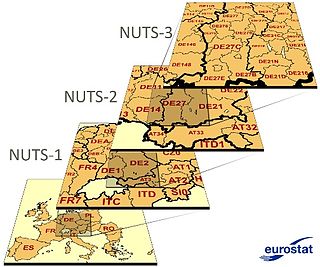
Nomenclature of Territorial Units for Statistics or NUTS is a geocode standard for referencing the administrative divisions of countries for statistical purposes. The standard, adopted in 2003, is developed and regulated by the European Union, and thus only covers the EU member states in detail. The Nomenclature of Territorial Units for Statistics is instrumental in the European Union's Structural Funds and Cohesion Fund delivery mechanisms and for locating the area where goods and services subject to European public procurement legislation are to be delivered.

In the NUTS codes of Finland (FI), the three levels are:

<span class="mw-page-title-main">NUTS statistical regions of Denmark</span>

The Nomenclature of Territorial Units for Statistics (NUTS) is a geocode standard for referencing the administrative division of Denmark for statistical purposes. The standard is developed and regulated by the European Union. The NUTS standard is instrumental in delivering the European Union's Structural Funds. The NUTS code for Denmark is DK and a hierarchy of three levels is established by Eurostat. Below these is a further levels of geographic organisation - the local administrative unit (LAU). In Denmark, the LAU 1 are municipalities and the LAU 2 is Parishes.

<span class="mw-page-title-main">International Territorial Level</span> Geographic classification system in the United Kingdom

International Territorial Level (ITL) is a geocode standard for referencing the subdivisions of the United Kingdom for statistical purposes, used by the Office for National Statistics (ONS). From 2003 and until 2020 it functioned as part of the European Union and European Statistical System's geocode standard Nomenclature of Territorial Units for Statistics or NUTS.

<span class="mw-page-title-main">NUTS statistical regions of the Czech Republic</span>

The Nomenclature of Territorial Units for Statistics (NUTS) is a geocode standard for referencing the subdivisions of the Czech Republic for statistical purposes. The standard is developed and regulated by the European Union. The NUTS standard is instrumental in delivering the European Union's Structural Funds. The NUTS code for the Czech Republic is CZ and a hierarchy of three levels is established by Eurostat. Below these is a further levels of geographic organisation - the local administrative unit (LAU). In the Czech Republic, the LAU 1 is districts and the LAU 2 is municipalities.

<span class="mw-page-title-main">NUTS statistical regions of Ireland</span> Statistical regions of Ireland

Ireland uses the Nomenclature of Territorial Units for Statistics (NUTS) geocode standard for referencing country subdivisions for statistical purposes. The standard is developed and regulated by the European Union. The NUTS standard is instrumental in delivering European Structural and Investment Funds. The NUTS code for Ireland is IE and a hierarchy of three levels is established by Eurostat. A further level of geographic organisation, the local administrative unit (LAU), in Ireland is the local electoral area.

In the NUTS codes of Italy (IT), the three levels are:

The NUTS codes of Hungary have three levels:

<span class="mw-page-title-main">NUTS statistical regions of Austria</span>

The Nomenclature of Territorial Units for Statistics (NUTS) is a geocode standard for referencing the subdivisions of Austria for statistical purposes. The standard is developed and regulated by the European Union. The NUTS standard is instrumental in delivering the European Union's Structural Funds. The NUTS code for Austria is AT and a hierarchy of three levels is established by Eurostat. Below these is a further levels of geographic organisation - the local administrative unit (LAU). In Austria, the LAU 2 is municipalities.

<span class="mw-page-title-main">NUTS statistical regions of Bulgaria</span>

The Nomenclature of Territorial Units for Statistics (NUTS) is a geocode standard for referencing the subdivisions of Bulgaria for statistical purposes. The standard is developed and regulated by the European Union. The NUTS standard is instrumental in delivering the European Union's Structural Funds. The NUTS code for Bulgaria is BG and a hierarchy of three levels is established by Eurostat. Below these is a further levels of geographic organisation - the local administrative unit (LAU). In Bulgaria, the LAU 1 is municipalities and the LAU 2 is settlements.

<span class="mw-page-title-main">NUTS statistical regions of Belgium</span>

The Nomenclature of Territorial Units for Statistics (NUTS) is a geocode standard for referencing the subdivisions of Belgium for statistical purposes. The standard is developed and regulated by the European Union. The NUTS standard is instrumental in delivering the European Union's Structural Funds. The NUTS code for Belgium is BE and a hierarchy of three levels is established by Eurostat. Below these is a further levels of geographic organisation - the local administrative unit (LAU). In Belgium, the LAUs are municipalities.

In the NUTS codes of France (FR), the three levels are:

The Nomenclature of Territorial Units for Statistics (NUTS) is a geocode standard for referencing the subdivisions of Switzerland for statistical purposes. As a member of EFTA Switzerland is included in the NUTS standard, although the standard is developed and regulated by the European Union, an organization that Switzerland does not belong to. The NUTS standard is instrumental in delivering the European Union's Structural Funds. The NUTS code for Switzerland is CH and a hierarchy of three levels is established by Eurostat. Below these is a further levels of geographic organisation - the local administrative unit (LAU). In Switzerland, the LAUs are districts (LAU-1) and municipalities (LAU-2).

The Nomenclature of Territorial Units for Statistics (NUTS) is a geocode standard for referencing the subdivisions of Estonia for statistical purposes. The standard is developed and regulated by the European Union. The NUTS standard is instrumental in delivering the European Union's Structural Funds. The NUTS code for Estonia is EE and a hierarchy of three levels is established by Eurostat. Below these is a further levels of geographic organisation - the local administrative unit (LAU). In Estonia, the LAU 1 is counties and the LAU 2 are municipalities.

<span class="mw-page-title-main">NUTS statistical regions of Greece</span> Overview of Greek NUTS statistical regions

The NUTS codes of Greece are part of the Nomenclature of Territorial Units for Statistics, an official nomenclature of the European Commission used by Eurostat for statistical purposes.

<span class="mw-page-title-main">NUTS statistical regions of Poland</span>

In the NUTS codes of Poland (PL), the three levels are:

<span class="mw-page-title-main">NUTS statistical regions of Cyprus</span>

The Nomenclature of Territorial Units for Statistics (NUTS) is a geocode standard used for referencing the subdivisions of Cyprus for statistical purposes. The standard is developed and regulated by the European Union. The NUTS standard is instrumental in delivering the European Union's Structural Funds. The NUTS code assigned to Cyprus is CY, and Eurostat has established a hierarchical structure consisting of three levels. However, Cyprus does not have subdivisions covered by the NUTS levels, as its population is small enough to be covered within a single level.

<span class="mw-page-title-main">NUTS statistical regions of Portugal</span> Statistical regions of Portugal

The Nomenclature of Territorial Units for Statistics (NUTS) is developed by Eurostat, and employed in both Portugal and the entire European Union for statistical purposes. The NUTS branch extends from NUTS1, NUTS2 and NUTS3 regions, with the complementary LAU sub-categorization being used to differentiate the local areas, of trans-national importance.

In the NUTS codes of Slovenia (SI), the three levels are:

<span class="mw-page-title-main">NUTS statistical regions of Turkey</span> Administrative divisions in Turkey

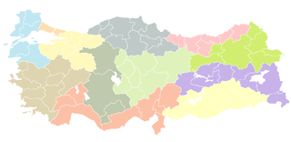
As a candidate country of the European Union, Turkey (TR) is included in the Nomenclature of Territorial Units for Statistics (NUTS). Defined in 2002 in agreement between Eurostat and the Turkish authorities, Turkey's NUTS classifications are officially termed statistical regions, as Turkey is not a member of the EU and Eurostat only defines NUTS for member states. The three NUTS levels are:

References

  1. "Revision to the Irish NUTS2 and NUTS3 regions". cso.ie.[ dead link ]
  2. Commission Regulation (EU) 2016/2066 of 21 November 2016 amending the annexes to Regulation (EC) No 1059/2003 of the European Parliament and of the Council on the establishment of a common classification of territorial units for statistics (NUTS)
  3. Brandenburg merged from DE41 (Brandenburg-Nordost) and DE42 (Brandenburg-Südwest) in 2009: see http://ec.europa.eu/eurostat/documents/345175/629341/DE_1_V4_draft2_OK.pdf
  4. "History of NUTS – NUTS – Nomenclature of territorial units for statistics – Eurostat".
  5. Eurostat documents 2016

Sources