Nador, Tipaza

Last updated
Nador
الناظور
Commune and town

Nador (Algerie).JPG

Nador
Dz - 42-15 - Nador - Wilaya de Tipaza map.svg
Algeria location map.svg
Red pog.svg
Nador
Coordinates: 36°34′11″N2°23′35″E / 36.569769°N 2.39296°E / 36.569769; 2.39296
CountryFlag of Algeria.svg  Algeria
Province Tipaza Province
District Sidi Amar District
Population (2008)
  Total 9,588
Time zone CET (UTC+1)

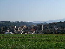
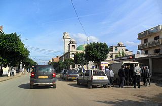
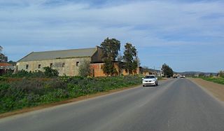
Nador is a town and commune in Tipaza Province in northern Algeria. [1]

Communes of Algeria administrative division of Algeria

The municipalities of Algeria form the second level of administrative subdivisions of Algeria. As of 2002, there were 1,541 municipalities in the country.

Tipaza Province Province in Algeria

Tipaza or Tipasa is a province (wilaya) on the coast of Algeria, Its capital is Tipasa, 50 km west of the capital of Algeria.

Algeria country in North Africa

Algeria, officially the People's Democratic Republic of Algeria, is a country in the Maghreb region of North Africa. The capital and most populous city is Algiers, located in the far north of the country on the Mediterranean coast. With an area of 2,381,741 square kilometres (919,595 sq mi), Algeria is the tenth-largest country in the world, the world's largest Arab country, and the largest in Africa. Algeria is bordered to the northeast by Tunisia, to the east by Libya, to the west by Morocco, to the southwest by the Western Saharan territory, Mauritania, and Mali, to the southeast by Niger, and to the north by the Mediterranean Sea. The country is a semi-presidential republic consisting of 48 provinces and 1,541 communes (counties). It has the highest human development index of all non-island African countries.

Related Research Articles

Stade 8 Mai 1945 stadium in Algeria

8 May 1945 Stadium is a multi-use stadium in Sétif, Algeria. It is currently used mostly for football matches and is the home ground of ES Sétif. The stadium holds 25,000 people.

Aïn Benian, Algiers is a commune in Algiers Province and suburb of the city of Algiers in northern Algeria. As of the 2008 census, the commune had a population of 68,354.

Beni Messous is a commune in Algiers Province and suburb of the city of Algiers in northern Algeria. As of the 2008 census, the commune had a population of 36,191.

Fassala Commune and town in Hodh Ech Chargui, Mauritania

Fassala , Fassale, Fessale, or Vassale is a town and commune in the Hodh Ech Chargui Region of south-eastern Mauritania, on the Malian border.

Tân Hoa is a commune () and village in Lục Ngạn District, Bắc Giang Province, in northeastern Vietnam.

Birtouta Commune and town in Algiers Province, Algeria

Birtouta is a town and commune in Algiers Province, Algeria. As of 2008, the commune had a total population of 30,575.

Tessala El Merdja is a town and commune in Algiers Province, Algeria. As of 1998, the commune had a total population of 10,792.

Hammamet, Algiers Commune and town in Algiers Province, Algeria

Hammamet is a town and commune in Algiers Province, Algeria. In 1998 the commune had a total population of 15,879.

Zmalet El Emir Abdelkader Commune and town in Tiaret Province, Algeria

Zmalet El Emir Abdelkader is a town and commune in Tiaret Province in north-western Algeria.

Ain Tagourait is a town and commune in Tipaza Province in northern Algeria.

Attatba is a town and commune in Tipaza Province in northern Algeria.

Bouharoun is a town and commune in Tipaza Province in northern Algeria.

Bourkika Commune and town in Tipaza Province, Algeria

Bourkika is a town and commune in Tipaza Province in northern Algeria.The territory of the municipality is located to the southeast of the wilaya, at 36.4931118n, 2.475915e about 18 km southeast of Tipaza. In 1984, Bourkika became part of the commune of Douaouda.

Chaiba is a town and commune in Tipaza Province in northern Algeria.

Douaouda Commune and town in Tipaza Province, Algeria

Douaouda is a town and commune in Tipaza Province in northern Algeria.

Khemisti is a town and commune in Tipaza Province in northern Algeria.

Messelmoun is a town and commune in Tipaza Province in northern Algeria.

Sidi Amar is a town and commune in Tipaza Province in northern Algeria.

Sidi Rached Commune and town in Tipaza Province, Algeria

Sidi Rached is a town and commune in Tipaza Province in northern Algeria.

Sidi Semiane is a town and commune in Tipaza Province in northern Algeria.

References

  1. "Communes of Algeria". Statoids. Retrieved December 12, 2010.

Coordinates: 36°34′11″N2°23′35″E / 36.56972°N 2.39306°E / 36.56972; 2.39306

Geographic coordinate system Coordinate system

A geographic coordinate system is a coordinate system that enables every location on Earth to be specified by a set of numbers, letters or symbols. The coordinates are often chosen such that one of the numbers represents a vertical position and two or three of the numbers represent a horizontal position; alternatively, a geographic position may be expressed in a combined three-dimensional Cartesian vector. A common choice of coordinates is latitude, longitude and elevation. To specify a location on a plane requires a map projection.