Hadjout

Last updated
Hadjout
حجـوط (ar)
ⵃⴰⵊⵊⵓⵟ (be)
Commune and town
Centre de la ville.jpg
The city center of Hadjout
Nickname: 
Marengo
Dz - 42-12 - Hadjout - Wilaya de Tipaza map.svg
CountryFlag of Algeria.svg  Algeria
Province Tipaza Province
Government
   Mayor M’hamed Gassaf
Area
  Land202 sq mi (523 km2)
Population
 (2008 [1] )
  Total65,300
Time zone UTC+1 (CET)
Postal code
42001–4212
Area code (+213) 048
Climate Csa

Hadjout formerly Marengo during French colonization is a town and commune in Tipaza Province in northern Algeria, approximately 78km to the west of the capital Algiers. [2]

Contents

History

In 1927 the watering trough and the semicircular basin which occupied the crossroads of the two main roads disappeared and were replaced by the Monument to the Dead of the War of 1914-1918, which marked the town center of Marengo Hadjout. Marengo-bassin.jpg
In 1927 the watering trough and the semicircular basin which occupied the crossroads of the two main roads disappeared and were replaced by the Monument to the Dead of the War of 1914–1918, which marked the town center of Marengo Hadjout.

In 1848, the village was named Marengo. In 1958, the commune became part of the department of Algiers. After Algerian independence, it was renamed Hadjout.

Marengo was founded on September 17, 1848; the plan of the village was signed by the captain of the genius Victor de Malglaive on December 29, 1849. By decree of February 11, 1851 that Louis-Napoleon Bonaparte, French, Signa, this village of colonists was given the name of Marengo, to honor the dedication of Colonel Gaspard, Joseph, Marie Caponne (1787-1862) who participated in the Napoleonic and Algerian conquests.

Transport

Hadjout has a large bus station providing inter-wilayas links, plus an urban railway station, which guarantees connections between Hadjout and other localities.

The road transport network of the municipality consists essentially of three national roads: the national road 42, linking Nador to the north and To the southeast, National Road 42A to reach Boumedfaa to the south, and National Route 67 Algeria, the main road to the north-east Koléa and further on Tessala El Merdja.

Demography

In 1926, Marengo counted 5217 inhabitants, of which 1200 were of European origin. The population then increased rapidly due to the birth rate of ethnic Algerians, the attraction of the center, and then external events that caused both a European and Algerian influx to the town, considered a safer place. At the 1954 census, the commune counted 13,400 inhabitants, including 122 foreigners and 10822 Algerians.

In 1960, according to the figures communicated by Mr. Frachon, there were about 19,500 inhabitants, 3,500 Europeans and 16,000 Algerian Muslims. The Europeans had a total of 812 families (average 3.10 people per family) the Muslims 2444 (average 4.52 people per family). The density of the population is then 125.76 inhabitants per square kilometer.

After the independence of Algeria in 1962, the municipality was renamed Hadjout (named after a local tribe) and counted 10000 inhabitants. At the 1998 census, the commune of Hadjout had 44,065 residents. In 2008, the population of the commune was 48,561.

Economy

Hadjout is known mainly for its agricultural side, it is one of the most important cities of the Metidja. A daily market with an area of 11500 m 2 attracts the clientele of the surrounding wilayas, it stands at the western exit of the city. A communal covered market was built during the colonial period in 1935. Apart from the agricultural side, it also has an important industrial zone for the region at the northern exit of the city, and several dealers of vehicles of the major French, Japanese, Korean and Chinese brands have settled in the city.

Sport

Stade 5 Juillet 1962 in Hadjout. Stade du 5 juillet de HADJOUT.jpg
Stade 5 Juillet 1962 in Hadjout.

The city's sports infrastructure consists mainly of a football stadium built during the colonial era. It was redeveloped by an extension of five bleachers and the ground covered with a lawn plus five playgrounds. The sports hall hosts many sports competitions and is also used as a theater and receives various events, including a gym.

The main sports clubs of Hadjout are:

Mayors of Hadjout


The city, still called by its French name Marengo, is featured in the beginning of Albert Camus' 1942 novel The Stranger as the place visited by Meursault, the protagonist, to mourn the death of his mother.

Related Research Articles

<span class="mw-page-title-main">Algiers</span> Capital and largest city of Algeria

Algiers is the capital and largest city of Algeria. The city's population at the 2008 census was 2,988,145 and in 2020 was estimated to be around 4,500,000. Algiers is in the north-central part of Algeria.

Articles related to Algeria include:

Algeria, since December 18, 2019, is divided into 58 wilayas (provinces). Prior to December 18, 2019, there were 48 provinces. The 58 provinces are divided into 1,541 baladiyahs (municipalities). The name of a province is always that of its capital city.

<span class="mw-page-title-main">Boumerdès Province</span> Province of Algeria

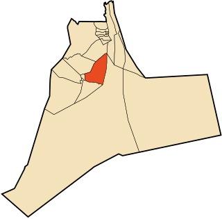
Boumerdès is a province (wilaya) of northern Algeria, located in the Kabylia region, between Algiers and Tizi-Ouzou, with its capital at the coastal city of Boumerdès just east of Algiers.

<span class="mw-page-title-main">Tipaza Province</span> Province of Algeria

Tipaza or Tipasa is a province (wilaya) on the coast of Algeria, Its capital is Tipaza, 50 km west of the capital of Algeria.

<span class="mw-page-title-main">Bordj Bou Arréridj Province</span> Province of Algeria

Bordj Bou ArréridjProvince is a province (wilaya) in northern Algeria around 200 km from the capital Algiers. It is considered as a crossroads between the east and west, the north and south.

<span class="mw-page-title-main">Relizane Province</span> Province of Algeria

Relizane is a province (wilaya) of Algeria. Relizane is the capital. Other localities include Bendaoud, Bouzegza, Hamri, Kalaa, Mazouna and Zemmoura. The Wilaya of Relizane massacres of 4 January 1998 happened in Relizane.

<span class="mw-page-title-main">Sidi Daoud</span>

Sidi Daoud is a farming town in north-central Algeria, on the west bank of the Sebaou River, a few kilometers downstream from its mouth. It is the capital of a municipality dominated by the mountain of Bouberak, including the coastal village of Sahel Bouberak and the zawiya of Sidi Amar Cherif. This municipality is one of three constituting the Baghlia District in eastern Boumerdès Province. As of 2008, the population of the municipality is 16,900.

<span class="mw-page-title-main">Boumerdès</span> City in Boumerdès Province, Algeria

Boumerdès is the capital city of Boumerdès Province, Algeria. It is located on the Mediterranean Sea. It had a population of 28,500 in 1998 and 15,000 in 1987.

<span class="mw-page-title-main">Miliana</span> Commune and town in Aïn Defla, Algeria

Miliana is a commune in Aïn Defla Province in northwestern Algeria. It is the administrative center of the daïra, or district, of the same name. It is approximately 114 kilometres (71 mi) southwest of the Algerian capital, Algiers. The population was estimated at 44,201 in 2008. The town is located south of the Dahra Range, on the wooded southern flank of Mount Zaccar Rherbi, five kilometers north of the Chelif River, and overlooking the Zaccar plateau to the west.

<span class="mw-page-title-main">Algiers Province</span> Province of Algeria

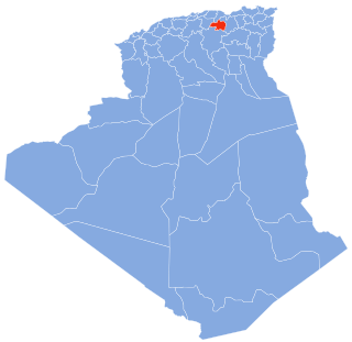
Algiers Province is a province (wilayah) in Algeria, named after its capital, Algiers, which is also the national capital. It is adopted from the old French department of Algiers and has a population of about 8 million. It is the most densely populated province of Algeria, and also the smallest by area.

<span class="mw-page-title-main">Belouizdad, Algiers</span> Place in Algiers, Algeria

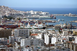
Mohamed Belouizdad is a quarter of Algiers, Algeria in Algiers Province. The quarter was formerly known as Belcourt during the French colonisation period. It was renamed as Hamma-El Annasser after Algerian independence, before the present name Belouizdad was adopted in 1992 in honour of the Algerian militant and nationalist Mohamed Belouizdad who lived in the quarter.

<span class="mw-page-title-main">Khemis Miliana</span> City and Commune in Aïn Defla Province, Algeria

Khemis Miliana is a town in northern Algeria of around 210000 inhabitants. It is a university town located 120 kilometers west of Algiers. It was known as Malliana in Roman times, then Affreville during the French colonial era. It should not be confused with the smaller city of Miliana nearby.

<span class="mw-page-title-main">Thénia</span> Place in Boumerdès, Algeria

Thénia (الثنية), sometimes written as Thenia, with around 40,000 inhabitants, is the chief town in the daïra of the same name, in the wilaya of Boumerdès, in northern Algeria. Historically, the name is a contraction of "Theniet Beni Aicha", the Arabic translation of the Kabyle Berber toponym Tizi n At Ɛica. The steep-sided pass, which is only about 800 metres (2,600 ft) wide at its narrowest point, is sometimes taken to mark the transition between Mitidja and Grande Kabylie.

<span class="mw-page-title-main">Damous</span> Commune and town in Tipaza Province, Algeria

Damous is a town and commune in Tipaza Province in northern Algeria.

Sidi Ghiles is a town on Algeria's Mediterranean coast. The municipality of Novi is located about 32 kilometres (20 mi) west of Tipasa and 7 kilometres (4.3 mi) southwest of Cherchell. This agricultural locality is 100 kilometres (62 mi) from Algiers.

<span class="mw-page-title-main">Tadmaït</span> Commune and town in Tizi Ouzou Province, Algeria

Tadmaït is a town and commune in Tizi Ouzou Province in northern Algeria, located 18 kilometers west of Tizi Ouzou and 85 kilometers east of Algiers.

Union Sportive Musulmane Madinet Hadjout, known as USMM Hadjout or simply USMMH for short, is an Algerian football club based in Hadjout. The club was founded on 5 March 1947 and its colours are green and white. Their home stadium, Stade du 5-Juillet-1962, has a capacity of 10,000 spectators. The club is currently playing in the Inter-Régions Division.

Mohamed Seghir Boushaki, was an Algerian Kabyle politician after the French conquest of Algeria.

Zawiyet Sidi Amar Cherif, or Zawiyet Sidi Daoud, is a zawiya school located in Boumerdès Province in Algeria.

References

  1. Recensement 2008 de la population algérienne, wilaya de Tipaza, sur le site de l'ONS.
  2. "Communes of Algeria". Statoids. Retrieved December 12, 2010.

36°31′N2°25′E / 36.517°N 2.417°E / 36.517; 2.417