
Badin is a town located in Stanly County, North Carolina, United States. At the 2010 census, the town had a total population of 1,974.

The Yadkin River is one of the longest rivers in the US state of North Carolina, flowing 215 miles (346 km). It rises in the northwestern portion of the state near the Blue Ridge Parkway's Thunder Hill Overlook. Several parts of the river are impounded by dams for water, power, and flood control. The river becomes the Pee Dee River at the confluence of the Uwharrie River south of the community of Badin and east of the town of Albemarle. The river then flows into South Carolina near Cheraw, which is at the Fall Line. The entirety of the Yadkin River and the Great Pee Dee River is part of the Yadkin-Pee Dee River Basin.

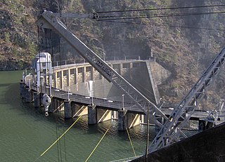
Badin Lake is one of a series of lakes created by the damming of the Yadkin-Pee Dee River in the Uwharrie Lakes Region of the United States. The Badin Lake Dam was built in 1917 to support local aluminum smelting plant, Alcoa, and the associated community of Badin was named for the founder, Adrien Badin. The power generation unit was sold to Cube Hydro Carolinas in February 2017. Badin Lake is in the Piedmont area of North Carolina. It is contained by Narrows Dam at the town of Badin, North Carolina. Sitting within a valley, the lake is very deep, with a maximum depth of 190 ft. The lake occupies 5,350 acres (22 km2) and has 115 mi (185 km) of shoreline. Its waters have an average summer temperature of 84.4 °F (29.1 °C) and an average winter temperature of 50.6 °F (10.3 °C). No ferries cross Badin Lake. The northernmost point of Morrow Mountain State Park is roughly 2 miles (3.2 km) downstream from Narrows Dam. The lake lies within Stanly, Davidson, Montgomery, and Rowan counties. Much of the lake's eastern shoreline lies within the Uwharrie National Forest.

The Guard Island Light is a lighthouse on a small island near the entrance to the Tongass Narrows, in Clarence Strait in southeastern Alaska. The western entrance to the Behm Canal also lies nearby.

The Cedarock Historical Farm, located at Cedarock Park in Alamance County, North Carolina, provides an example of life on a farm in North Carolina during the 19th Century. Populated with farm animals, antique and replica farm equipment, and a farmhouse, the Historical Farm provides a fun, education stop while visiting Cedarock Park.
Calderwood Dam is a hydroelectric dam located along the Little Tennessee River in Blount and Monroe counties, in the U. S. state of Tennessee. Completed in 1930, the dam is owned and maintained by Tapoco, a subsidiary of the Aluminum Company of America (Alcoa), although the Tennessee Valley Authority (TVA) controls the dam's reservoir levels from Fontana Dam further upstream. Calderwood Dam is named for Alcoa engineer Isaac Glidden Calderwood (1871–1941), who supervised much of the company's early Little Tennessee River operations.

The former Saratoga Gas, Electric Light and Power Company Complex is located near the northern boundary of Saratoga Springs, New York, United States. It is a seven-acre parcel with two brick buildings on it. In the 1880s it became the thriving resort city's first power station.
Alcoa Power Generating, Inc. is a subsidiary of Alcoa Inc., headquartered in Pittsburgh, Pennsylvania. Its three divisions were independent subsidiaries before being consolidated into Alcoa Power Generating, Inc. (APGI). These three projects have produced hydroelectric power and manage impoundments which also provide flood control; recreation, residential and business opportunities; and wildlife habitat.

The American Tobacco Historic District is a historic tobacco factory complex and national historic district located in Durham, Durham County, North Carolina. The district encompasses 14 contributing buildings and three contributing structures built by the American Tobacco Company and its predecessors and successors from 1874 to the 1950s. Located in the district is the separately listed Italianate style W. T. Blackwell and Company building. Other notable contributing resources are the Romanesque Revival style Hill Warehouse (1900), Washington Warehouse (1902–07), the Lucky Strike Building (1901–02), and Reed Warehouse; Noell Building ; Power Plant and Engine House (1929–39); and the Art Moderne style Fowler (1939) Strickland (1946) and Crowe (1953) buildings.

Buffalo Mill Historic District is a national historic district located at Buffalo, Union County, South Carolina. The district encompasses 190 contributing buildings and 2 contributing structures associated with the Buffalo Mill textile mill complex and mill village. The mill complex includes the main mill, mill office, power house, ice factory, mill warehouse, company store, and company bank/drug store. The main mill building features applied stylized Romanesque Revival detailing. The mill village housing varies from large, free-classic, Queen Anne style supervisor's houses, to shingle-style bungalows, to simple, one-story, workers residences. The village also includes a school and a baseball field/park.

Glencoe Mill Village Historic District is a national historic district located at Glencoe, Alamance County, North Carolina. It encompasses 48 contributing buildings and 6 contributing structures built between 1880 and 1882 in Glencoe.
Patterson School Historic District is a historic agricultural and Episcopal mission school complex and national historic district located at Legerwood, Caldwell County, North Carolina. The complex includes 13 contributing buildings, 2 contributing sites, and 3 contributing structures. Notable contributing resources include the Colonial Revival-style Palmyra Hall (1927), Sarah Joyce Lenoir Memorial Library, Gard Hall (1920-1921), Headmaster's House (1912), Buffalo Creek Dam (pre-1940), Milk House (1945), two Barns, North Silo (1920s), Chapel of Rest (1918), Jones-Patterson Cemetery, Hugh A. Dobbin House, and Tudor Revival-style Edgar A. Dobbin House (Greystone) (1930s). In 1994 the Episcopal Diocese of Western North Carolina sold the Patterson School property.

Capitola Manufacturing Company Cotton Yarn Mill, also known as the Marshall Mill and Power Company, is a historic cotton mill complex located at Marshall, Madison County, North Carolina. The main mill building is a three-story brick building built about 1905. It was raised to three stories in 1928. It measures approximately 108 feet (33 m) by 116 feet (35 m), with a low-pitched gabled roof, and windows on three sides. Also on the property is a contributing boiler house and water tank.

Spray Industrial Historic District is a national historic district located at Eden, Rockingham County, North Carolina. It encompasses 70 contributing buildings, 9 contributing structures, and 1 contributing object in an industrial section of the town of Eden. It includes buildings associated with eight textile mill complexes, mill village housing, and seven commercial buildings. Notable contributing resources include the Smith River Dam and Spray Power canal, Morehead Cotton Mill complex, "Superintendent's" House, Imperial Bank and Trust Company (1912), Leaksville Cotton Mills complex, Spray Mercantile Building, Spray Cotton Mills complex, Lily Mill complex, Nantucket Mills complex designed by R. C. Biberstein, American Warehouse Company complex, Rhode Island Mill complex, Phillips-Chatham House, and Spray Woolen Mill complex.

Washington Mills-Mayodan Plant, also known as Mayo Mills, Washington Group-Mayodan Plant, and Tultex Corp.-Mayodan Plant, was a historic textile mill and national historic district located at Mayodan, Rockingham County, North Carolina. It encompassed four contributing buildings and two contributing structures in the town of Mayodan. The main spinning mill was built in 1895, and was a three-story, rectangular brick structure with a low-pitched gable roof. The mill was expanded several times between 1897 and 1954. It featured a four-story, one bay, tower with an open belfry at the top. Also on the property were the contributing knitting mill (1911), transformer house, railroad underpass, railroad spur, and frame wood shed. The mill closed in 1999.

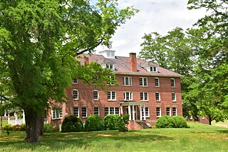
Badin Historic District is a national historic district located at Badin, Stanly County, North Carolina. The district encompasses 200 contributing buildings and 8 contributing sites in the company town of Badin. They were built starting about 1912 and include residential, institutional, and commercial structures in Gothic Revival and Bungalow / American Craftsman style architecture. The community was developed by the Southern Aluminum Company of America, later Alcoa, with Badin developed for white residents. Notable buildings include the Badin Hospital, Badin Elementary School, 24 Henderson Street, 28-30 Henderson Street duplex (1914), 27-33 Boyden Street quadruplex (1913-1914), Badin Club House and Club House Annex, and Badin Baptist Church.

West Badin Historic District is a national historic district located at Badin, Stanly County, North Carolina. The district encompasses 153 contributing buildings and 4 contributing sites in the company town of Badin. They were built starting about 1912 and include residential, institutional, and commercial structures in Gothic Revival and Bungalow / American Craftsman style architecture. The community was developed by the Southern Aluminum Company of America, later Alcoa, with West Badin developed for African-American residents. Notable buildings include the houses at 704 Roosevelt Street and 417 Jackson Street, 228-226 Lincoln Avenue duplex, Baptist Church, McDonald's Chapel AME Zion Church, and Badin Colored School.

Star Milling and Electric Company Historic District, also known as Star Mill Falls and Star Gristmill, is a historic industrial complex and national historic district located in Lima Township, LaGrange County, Indiana. The district encompasses one contributing building, one contributing site, and two contributing structures. They are a small hydroelectric powerhouse (1929), two dams (1929), and the site of the original 1870 grist mill / hydroelectric generating plant. The old mill generated electric power from 1911 to 1929, and in 1930 the new powerhouse began operation.
A narrows is a fluvial landform.


