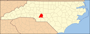
Badin, North Carolina

Last updated

Badin, North Carolina
Badin, North Carolina.jpg
Buildings along Falls Road in Badin
Motto: 
"A French-Flavored town at the foot of the Uwharries"
NCMap-doton-Badin.PNG
Location of Badin, North Carolina
Coordinates: 35°24′26″N80°07′06″W / 35.40722°N 80.11833°W / 35.40722; -80.11833 [1]
CountryUnited States
State North Carolina
County Stanly
Area
[2]
  Total1.81 sq mi (4.70 km2)
  Land1.81 sq mi (4.70 km2)
  Water0.00 sq mi (0.00 km2)
Elevation
[1]
522 ft (159 m)
Population
 (2020)
  Total2,024
  Density1,116.38/sq mi (431.07/km2)
Time zone UTC-5 (Eastern (EST))
  Summer (DST) UTC-4 (EDT)
ZIP code
28009
Area codes 704 and 980
FIPS code 37-02960 [3]
GNIS feature ID2405196 [1]
Website www.badin.org

Badin is a town located in Stanly County, North Carolina, United States. At the 2010 census, the town had a total population of 1,974.

Contents

History

The Badin Historic District, Doerschuk Site, Hardaway Site, Narrows Dam and Power Plant Complex, and West Badin Historic District are listed on the National Register of Historic Places. [4]

Geography

Badin is located on the south end of Badin Lake which is a reservoir formed by damming the Yadkin River. North Carolina Highway 740 passes through the town. Albemarle is four miles to the southwest and New London is six miles to the northwest. [5]

According to the United States Census Bureau, the town has a total area of 1.6 square miles (4.1 km2), all land.

Demographics

Historical population
CensusPop.Note
1950 2,126
1960 1,905−10.4%
1970 1,626−14.6%
1980 1,514−6.9%
1990 1,481−2.2%
2000 1,154−22.1%
2010 1,97471.1%
2020 2,0242.5%
U.S. Decennial Census [6]

2020 census

Badin racial composition [7]
RaceNumberPercentage
White (non-Hispanic)1,07653.16%
Black or African American (non-Hispanic)72135.62%
Native American 110.54%
Asian 130.64%
Pacific Islander 10.05%
Other/Mixed 834.1%
Hispanic or Latino 1195.88%

As of the 2020 United States census, there were 2,024 people, 506 households, and 331 families residing in the town.

2000 census

At the census [3] of 2000, there were 1,154 people, 494 households, and 328 families residing in the town. The population density was 719.2 inhabitants per square mile (277.7/km2). There were 586 housing units at an average density of 365.2 per square mile (141.0/km2). The racial makeup of the town was 63.26% White, 35.62% African American, 0.00% Native American, 0.00% Asian, 0.00% Pacific Islander, 0.17% from other races, and 0.95% from two or more races. 0.61% of the population were Hispanic or Latino of any race.

There were 494 households, out of which 33.0% had children under the age of 18 living with them, 48.0% were married couples living together, 14.0% had a female householder with no husband present, and 33.6% were non-families. 31.2% of all households were made up of individuals, and 17.8% had someone living alone who was 65 years of age or older. The average household size was 2.34 and the average family size was 2.91.

In the town, the population was spread out, with 25.3% under the age of 18, 7.5% from 18 to 24, 26.8% from 25 to 44, 22.3% from 45 to 64, and 18.2% who were 65 years of age or older. The median age was 39 years. For every 100 females, there were 83.5 males. For every 100 females age 18 and over, there were 78.1 males.

The median income for a household in the town was $27,031, and the median income for a family was $32,692. Males had a median income of $27,396 versus $21,417 for females. The per capita income for the town was $15,320. 12.2% of the population and 9.4% of families were below the poverty line. 10.7% of those under the age of 18 and 17.1% of those 65 and older were living below the poverty line.

Economy

Badin's major employer was ALCOA, which operated a large facility in Badin until 2010. ALCOA laid off most of the workers when it shut down the factory in 2007. Alcoa Power Generating continues to generate electricity using four area dams and is working to find new uses for the plant site.

Notable people

Related Research Articles

<span class="mw-page-title-main">Towns County, Georgia</span> County in Georgia, United States

Towns County is a county located in the northeastern part of the U.S. state of Georgia. As of the 2020 census, the population was 12,493. Its county seat is Hiawassee. The county was created on March 6, 1856, and named for lawyer, legislator, and politician George W. Towns.

<span class="mw-page-title-main">Hart County, Georgia</span> County in Georgia, United States

Hart County is a county located in the northeastern part of the U.S. state of Georgia. As of the 2020 census, the population was 25,828. The county seat is Hartwell.

<span class="mw-page-title-main">Lakeside, Missouri</span> Inactive City in Missouri, United States

Lakeside is an inactive city in Miller County, Missouri, United States, located along the Osage River near the Bagnell Dam. The population was 37 at the 2000 census. As of the 2020 census, the population was 0, with one housing unit.

<span class="mw-page-title-main">Wynot, Nebraska</span> Village in Nebraska, United States

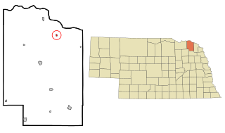
Wynot is a village in Cedar County, Nebraska, United States. The population was 217 at the 2020 census.

<span class="mw-page-title-main">Altamahaw, North Carolina</span> Census-designated place in North Carolina, United States

Altamahaw is a census-designated place (CDP) in Alamance County, North Carolina, United States. It is part of the Burlington, North Carolina Metropolitan Statistical Area. As of the 2010 census it had a population of 347. The community was listed as Altamahaw-Ossipee at the 2000 census, at which time the population was 996. The town of Ossipee incorporated in 2002 and currently has a population of 543. The remainder of the territory was reassigned as the Altamahaw CDP.

<span class="mw-page-title-main">Lansing, North Carolina</span> Town in North Carolina, United States

Lansing is a town in Ashe County, North Carolina, United States. The population was 126 at the 2020 census.

<span class="mw-page-title-main">Biltmore Forest, North Carolina</span> Town in North Carolina, United States

Biltmore Forest is a town in Buncombe County, North Carolina, United States. The population was 1,343 in 2010. It is part of the Asheville Metropolitan Statistical Area. Biltmore Forest is the second-wealthiest town in North Carolina by per capita income at $85,044.

<span class="mw-page-title-main">Mount Pleasant, North Carolina</span> Town in North Carolina, United States

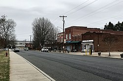
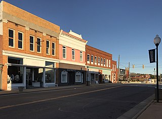
Mount Pleasant is a town located in eastern Cabarrus County, North Carolina, United States. As of the 2010 census, the town population was 1,652. The town center is located at the crossroads of Mount Pleasant Road and North Carolina Highway 73. NC Highway 49 skirts the town to the north on its way from Charlotte to Asheboro.

<span class="mw-page-title-main">Catawba, North Carolina</span> Town in North Carolina, United States

Catawba is a town in Catawba County, North Carolina, United States. The population was 603 at the 2010 census. It is part of the Hickory–Lenoir–Morganton Metropolitan Statistical Area. As with the county, the name recalls the Catawba people, the indigenous people who once inhabited the area.

<span class="mw-page-title-main">Hope Mills, North Carolina</span> Town in North Carolina, United States

Hope Mills is a town in Cumberland County, North Carolina, United States. Its population was 15,176 at the 2010 census.

<span class="mw-page-title-main">Lewisville, North Carolina</span> Town in North Carolina, United States

Lewisville is a town in Forsyth County, North Carolina, United States. The population was 13,388 at the 2020 census, up from 12,639 in 2010. It is a Piedmont Triad community.

<span class="mw-page-title-main">Harrellsville, North Carolina</span> Town in North Carolina, United States

Harrellsville is a town in Hertford County, North Carolina, United States. The population was 106 at the 2010 census.

<span class="mw-page-title-main">Norwood, North Carolina</span> Town in North Carolina, United States

Norwood is a town in Stanly County, North Carolina, United States. The population was 2,379 at the 2010 census.

<span class="mw-page-title-main">Danbury, North Carolina</span> City in North Carolina, United States

Danbury is a city located in Danbury Township, Stokes County, North Carolina, United States. As of the 2020 census, the city had a total population of 142. It is the county seat of Stokes County. Danbury is located on NC 8/89 approximately 20 miles (32 km) north of Winston-Salem and is the "Gateway to Hanging Rock". The Stokes County Government Center, Arts Council, school board, county jail, a public library, a post office, and other public services are found within the town limits. LifeBrite Community Hospital of Stokes is located about a half mile northwest of the town. North Stokes High School, a big part of town, is located 7.4 miles to the northwest.

<span class="mw-page-title-main">North Charleroi, Pennsylvania</span> Borough in Pennsylvania, United States

North Charleroi is a borough in Washington County, Pennsylvania, United States. The population was 1,302 at the 2020 census.

<span class="mw-page-title-main">Burnettown, South Carolina</span> Town in South Carolina, United States of America

Burnettown is a town in Aiken County, South Carolina, United States. The population was 3,105 at the 2020 census. It is part of the Augusta, Georgia metropolitan area. Burnettown is located in historic Horse Creek Valley.

<span class="mw-page-title-main">Great Falls, South Carolina</span> Town in South Carolina, United States

Great Falls is a town in Chester County, South Carolina, United States and is located fourteen miles southwest of Lancaster, South Carolina. The population was 1,951 at the 2020 census.

<span class="mw-page-title-main">Sharon, South Carolina</span> Town in South Carolina, United States

Sharon is a town in southwestern York County, South Carolina, United States. The population was 494 at the 2010 census.

<span class="mw-page-title-main">Ridgeway, Virginia</span> Town in Virginia, United States

Ridgeway is a town in Henry County, Virginia, United States. The population was 742 at the 2010 census. It is part of the Martinsville Micropolitan Statistical Area. Martinsville Speedway, a NASCAR racetrack, is located between Ridgeway and the Martinsville city limits.

<span class="mw-page-title-main">Leon, West Virginia</span> Town in West Virginia, United States

Leon is a town in Mason County, West Virginia, United States, situated along the Kanawha River. The population was 137 at the 2020 census. It is part of the Point Pleasant, WV–OH Micropolitan Statistical Area.

References

  1. 1 2 3 U.S. Geological Survey Geographic Names Information System: Badin, North Carolina
  2. "ArcGIS REST Services Directory". United States Census Bureau. Retrieved September 20, 2022.
  3. 1 2 "U.S. Census website". United States Census Bureau . Retrieved 2008-01-31.
  4. "National Register Information System". National Register of Historic Places . National Park Service. July 9, 2010.
  5. Badin, NC, 7.5 Minute Topographic Quadrangle, USGS, 1981 (1991 rev.)
  6. "Census of Population and Housing". Census.gov. Retrieved June 4, 2015.
  7. "Explore Census Data". data.census.gov. Retrieved December 21, 2021.