Richfield, North Carolina

Last updated

Richfield, North Carolina
NCMap-doton-Richfield.PNG
Location of Richfield, North Carolina
Coordinates: 35°28′18″N80°15′31″W / 35.47167°N 80.25861°W / 35.47167; -80.25861
Country United States
State North Carolina
County Stanly
Government
  MayorTerry Deese
Area
[1]
  Total2.44 sq mi (6.32 km2)
  Land2.42 sq mi (6.27 km2)
  Water0.02 sq mi (0.05 km2)
Elevation
[2]
640 ft (200 m)
Population
 (2020)
  Total582
  Density240.30/sq mi (92.77/km2)
Time zone UTC-5 (Eastern (EST))
  Summer (DST) UTC-4 (EDT)
ZIP code
28137
Area code 704
FIPS code 37-56340 [3]
GNIS feature ID2407207 [2]
Website http://www.gorichfield.com

Richfield is a town in Stanly County, North Carolina, United States. The town was originally called "Ritchie's Field," for the prominent Ritchie family who established the post office, sawmill, and streets of the settlement.

Contents

Geography

According to the United States Census Bureau, the town has a total area of 2.1 square miles (5.4 km2), of which 2.1 square miles (5.4 km2) is land and 0.04 square miles (0.10 km2) (0.95%) is water.

Richfield is located at the junction of US Route 52 and State Highway 49.

Demographics

Historical population
CensusPop.Note
1900 73
1910 210187.7%
1920 177−15.7%
1930 22124.9%
1940 26620.4%
1950 237−10.9%
1960 29323.6%
1970 3064.4%
1980 37321.9%
1990 53543.4%
2000 515−3.7%
2010 61319.0%
2020 582−5.1%
U.S. Decennial Census [4]

2020 census

Richfield racial composition [5]
RaceNumberPercentage
White (non-Hispanic)51187.8%
Black or African American (non-Hispanic)305.15%
Native American 20.34%
Asian 122.06%
Other/Mixed 152.58%
Hispanic or Latino 122.06%

As of the 2020 United States census, there were 582 people, 196 households, and 148 families residing in the town.

2000 census

At the 2000 census, [3] there were 515 people, 197 households and 144 families residing in the town. The population density was 247.0 inhabitants per square mile (95.4/km2). There were 225 housing units at an average density of 107.9 per square mile (41.7/km2). The racial makeup of the town was 81.94% White, 14.37% African American, 2.14% Asian, 0.19% Pacific Islander, and 1.36% from two or more races. Hispanic or Latino of any race were 0.19% of the population.

There were 197 households, of which 34.0% had children under the age of 18 living with them, 56.9% were married couples living together, 12.2% had a female householder with no husband present, and 26.9% were non-families. 23.9% of all households were made up of individuals, and 9.1% had someone living alone who was 65 years of age or older. The average household size was 2.61 and the average family size was 3.13.

27.4% of the population were under the age of 18, 6.4% from 18 to 24, 29.7% from 25 to 44, 25.6% from 45 to 64, and 10.9% who were 65 years of age or older. The median age was 36 years. For every 100 females, there were 100.4 males. For every 100 females age 18 and over, there were 102.2 males.

The median household income was $40,083 and the family median income was $41,442. Males had a median income of $26,420 compared with $23,542 for females. The per capita income for the town was $15,334. About 4.7% of families and 5.7% of the population were below the poverty line, including 4.4% of those under age 18 and 12.1% of those age 65 or over.

Government

Richfield is governed by a mayor and town council system. Floyd Wilson was re-elected mayor on November 5, 2013, replacing Jim Misenheimer, long time mayor pro-tem Terry Deese became mayor June 2016 with the passing of Floyd Wilson. Former mayors include Terry Almond and Wade Barbee.

Related Research Articles

<span class="mw-page-title-main">Richfield, Idaho</span> City in Idaho, United States

Richfield is a city in Lincoln County, Idaho, in the United States. The population was 482 at the 2010 census.

<span class="mw-page-title-main">Galena, Indiana</span> Census-designated place in Indiana, United States

Galena is a census-designated place (CDP) in Floyd County, Indiana, United States. The population was 1,818 at the 2010 census. The CDP includes the town of Galena as well as the nearby town of Floyds Knobs and their immediate surroundings.

<span class="mw-page-title-main">Georgetown, Floyd County, Indiana</span> Place in Indiana, United States

Georgetown is a town in Floyd County, Indiana, United States. The population was 3,805 at the 2020 census.

<span class="mw-page-title-main">Richfield, Kansas</span> City in Morton County, Kansas

Richfield is a city in Morton County, Kansas, United States. As of the 2020 census, the population of the city was 30.

<span class="mw-page-title-main">Martin, Kentucky</span> City in Kentucky, United States

Martin is a home rule-class city in Floyd County, Kentucky, in the United States. The population was 634 as of the 2010 census.

<span class="mw-page-title-main">Missouri City, Missouri</span> City in Missouri, United States

Missouri City is a city in Clay County, Missouri, United States. The population was 217 at the 2020 census. It is part of the Kansas City metropolitan area.

<span class="mw-page-title-main">Paris, New York</span> Town in New York, United States

Paris is a town in Oneida County, New York, United States. The town is in the southeast part of the county and is south of Utica. The population was 4,411 at the 2010 census. The town was named after an early benefactor, Colonel Isaac Paris.

<span class="mw-page-title-main">Richfield, New York</span> Town in Otsego County, New York, US

Richfield is a town located in Otsego County, New York, United States. As of the 2010 census, the town had a population of 2,388. The Town of Richfield is located at the northern border of the county.

<span class="mw-page-title-main">Atkinson, North Carolina</span> Town in North Carolina, United States

Atkinson is a town in Pender County, North Carolina, United States. At the 2010 census, the town population was 299. It is part of the Wilmington Metropolitan Statistical Area.

<span class="mw-page-title-main">New London, North Carolina</span> Town in North Carolina, United States

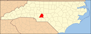
New London is a town in Stanly County, North Carolina, United States. The population was 600 at the 2010 census, and was estimated to be 724 as of 2019. The town lies between Albemarle and Richfield along U.S. 52 in the southern Piedmont region of the state, approximately 45 miles (72 km) east-northeast of Charlotte. It was the site of a gold mine, which was active during periods of the mid-1800s and early 1900s.

<span class="mw-page-title-main">Richfield, Ohio</span> Village in Ohio, United States

Richfield is a village in Summit County, Ohio, United States. The population was 3,648 at the 2010 census. The village and the adjacent Richfield Township are approximately equidistant between the downtown areas of Akron and Cleveland. It is part of the Akron metropolitan area. Richfield is the sister city of Wolfach, Germany.

<span class="mw-page-title-main">Richfield, Pennsylvania</span> Census-designated place in Pennsylvania, United States

Richfield is an unincorporated community and census-designated place (CDP) in Juniata and Snyder counties in Pennsylvania, United States. The population was 549 at the 2010 census.

<span class="mw-page-title-main">Annabella, Utah</span> Town in Utah, United States

Annabella is a town in Sevier County, Utah, United States. The population was 795 at the 2010 census, an increase over the 2000 figure of 603.

<span class="mw-page-title-main">Auburn, West Virginia</span> Town in West Virginia, United States

Auburn is a town in Ritchie County, West Virginia, United States. The population was 80 at the 2020 census.

<span class="mw-page-title-main">Harrisville, West Virginia</span> Town in West Virginia, United States

Harrisville is a town in Ritchie County, West Virginia, United States. It is the county seat of Ritchie County. Harrisville is located at the junction of State Routes 31 and 16, five miles south of U.S. 50. Within the community are an elementary school, the county board of education, many businesses, three banks, a library, offices of the Ritchie Gazette and The Pennsboro News, a municipal park, and North Bend Golf Course. North Bend Lake and North Bend State Park are located just outside town limits. Municipal elections are held every two years.

<span class="mw-page-title-main">Pennsboro, West Virginia</span> City in West Virginia, United States

Pennsboro is a city in Ritchie County, West Virginia, United States. The population was 1,050 at the 2020 census. The city is located at the junction of U.S. Route 50 and West Virginia Route 74; the North Bend Rail Trail also passes through the city.

<span class="mw-page-title-main">Pullman, West Virginia</span> Town in West Virginia, United States

Pullman is a town in Ritchie County, West Virginia, United States. The population was 134 at the 2020 census.

<span class="mw-page-title-main">Richfield, Adams County, Wisconsin</span> Town in Wisconsin, United States

Richfield is a town in Adams County in the U.S. state of Wisconsin. The population was 158 at the 2010 census. The ghost town of Pilot Knob was located in the town.

<span class="mw-page-title-main">Richfield, Wisconsin</span> Village in Washington County, Wisconsin

Richfield is a village in Washington County, Wisconsin, United States. The population was 11,739 at the 2020 census. The previously unincorporated communities of Hubertus and Pleasant Hill are located in the village, as well as the communities of Colgate and Lake Five, which are partially located in Richfield.

<span class="mw-page-title-main">Richfield, Wood County, Wisconsin</span> Town in Wisconsin, United States

References

  1. "ArcGIS REST Services Directory". United States Census Bureau. Retrieved September 20, 2022.
  2. 1 2 U.S. Geological Survey Geographic Names Information System: Richfield, North Carolina
  3. 1 2 "U.S. Census website". United States Census Bureau . Retrieved January 31, 2008.
  4. "Census of Population and Housing". Census.gov. Retrieved June 4, 2015.
  5. "Explore Census Data". data.census.gov. Retrieved December 21, 2021.