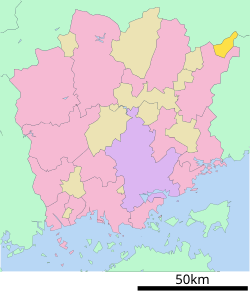
Tsuyama is a city in Okayama Prefecture, Japan. In February 2023, the city had an estimated population of 97,507 in 45,653 households and a population density of 190 persons per km2. The total area of the city is 506.33 square kilometres (195.50 sq mi).

Kamo was a town located in Tomata District, Okayama Prefecture, Japan.

Kagamino is a town located in Tomata District, Okayama Prefecture, Japan. As of 31 January 2023, the town had an estimated population of 12,425 in 5633 households and a population density of 30 persons per km2. The total area of the town is 419.68 square kilometres (162.04 sq mi).

Katsuta was a town located in Katsuta District, Okayama Prefecture, Japan.

Nagi is a town located in Katsuta District, Okayama Prefecture, Japan. As of 1 September 2022, the town had an estimated population of 5,738 in 1512 households and a population density of 83 persons per km². The total area of the town is 69.52 square kilometres (26.84 sq mi).
Ōhara was a town located in Aida District, Okayama Prefecture, Japan.

Higashiawakura was a village located in Aida District, Okayama Prefecture, Japan.

Mimasaka is a city located in Okayama Prefecture, Japan. As of 31 January 2023, the city had an estimated population of 25,946 in 12287 households and a population density of 60 persons per km2. The total area of the city is 429.29 square kilometres (165.75 sq mi).
Sakutō was a town located in Aida District, Okayama Prefecture, Japan.

Aida was a town located in Aida District, Okayama Prefecture, Japan.

Wakasa is a town located in Yazu District, Tottori Prefecture, Japan. As of 30 November 2022, the town had an estimated population of 2,852 in 1285 households and a population density of 14 persons per km2. The total area of the town is 199.18 square kilometres (76.90 sq mi).

Chizu is a town located in Yazu District, Tottori Prefecture, Japan. As of 1 January 2024, the town had an estimated population of 5,906 in 2681 households and a population density of 26.3 persons per km2. The total area of the town is 224.70 square kilometres (86.76 sq mi).

Kamigōri is a town located in Akō District, Hyōgo Prefecture, Japan. As of 1 March 2022, the town had an estimated population of 14,179 in 6426 households and a population density of 94 persons per km². The total area of the town is 150.26 square kilometres (58.02 sq mi).

Sayō is a town located in Sayō District, Hyōgo Prefecture, Japan. As of 31 March 2022, the town had an estimated population of 15,701 in 6797 households and a population density of 51 persons per km2. The total area of the town is 307.44 square kilometres (118.70 sq mi).

Shisō is a city in Hyōgo Prefecture, Japan. As of 31 May 2022, the city had an estimated population of 35,639 in 14694 households and a population density of 110 persons per km². The total area of the city is 658.54 square kilometres (254.26 sq mi).

Yazu is a town located in Yazu District, Tottori Prefecture, Japan. As of 30 November 2022, the town had an estimated population of 16,156 in 6140 households and a population density of 78 persons per km². The total area of the town is 206.71 square kilometres (79.81 sq mi).

Nishi-Awakura Station is a passenger railway station located in the village of Nishiawakura, Aida District, Okayama Prefecture, Japan. It is operated by the third-sector semi-public railway operator Chizu Express.

Awakura-Onsen Station is a passenger railway station located in the village of Nishiawakura, Aida District, Okayama Prefecture, Japan. It is operated by the third-sector semi-public railway operator Chizu Express.

Hyōnosen-Ushiroyama-Nagisan Kokutei Kōen (氷ノ山後山那岐山国定公園) is a Quasi-National Park in Hyōgo Prefecture, Tottori Prefecture, and Okayama Prefecture, Japan. It was founded on 10 April 1969 and has an area of 488.03 square kilometres (188.43 sq mi).

Mimasaka was a town located in Aida District, Okayama Prefecture, Japan.