
Located in Oceania, Tonga is a small archipelago in the South Pacific Ocean, directly south of Samoa and about two-thirds of the way from Hawaii to New Zealand. It has 169 islands, 36 of them inhabited, which are in three main groups – Vavaʻu, Haʻapai, and Tongatapu – and cover an 800-kilometre (500-mile)-long north–south line. The total size is just 747 km2 (288 sq mi). Due to the spread out islands it has the 40th largest Exclusive Economic Zone of 659,558 km2 (254,657 sq mi).

Mount Vesuvius is a somma-stratovolcano located on the Gulf of Naples in Campania, Italy, about 9 km (5.6 mi) east of Naples and a short distance from the shore. It is one of several volcanoes forming the Campanian volcanic arc. Vesuvius consists of a large cone partially encircled by the steep rim of a summit caldera, resulting from the collapse of an earlier, much higher structure.

The Ring of Fire is a tectonic belt of volcanoes and earthquakes.

Kīlauea is an active shield volcano in the Hawaiian Islands. It is located along the southeastern shore of Hawaii Island. The volcano is between 210,000 and 280,000 years old and grew above sea level about 100,000 years ago. Since the islands were settled, it has been the most active of the five volcanoes that together form the island and among the most active volcanoes on Earth. The most recent eruption occurred on June 3, 2024, along fissures that opened on the volcano's southwest rift zone.

Mount Mazama is a complex volcano in the western U.S. state of Oregon, in a segment of the Cascade Volcanic Arc and Cascade Range. A volcanic peak once existed, but it collapsed following a major eruption approximately 7,700 years ago, to be replaced by a caldera. The volcano is in Klamath County, in the southern Cascades, 60 miles (97 km) north of the Oregon–California border. Its collapse, due to the eruption of magma emptying the underlying magma chamber, formed a caldera that holds Crater Lake. Mount Mazama originally had an elevation of 12,000 feet (3,700 m), but following its climactic eruption this was reduced to 8,157 feet (2,486 m). Crater Lake is 1,943 feet (592 m) deep, the deepest freshwater body in the U.S. and the second deepest in North America after Great Slave Lake in Canada.

Mount Nyiragongo is an active stratovolcano with an elevation of 3,470 m (11,385 ft) in the Virunga Mountains associated with the Albertine Rift. It is located inside Virunga National Park, in the Democratic Republic of the Congo, about 12 km (7.5 mi) north of the town of Goma and Lake Kivu and just west of the border with Rwanda. The main crater is about two kilometres (1 mi) wide and usually contains a lava lake. The crater presently has two distinct cooled lava benches within the crater walls – one at about 3,175 m (10,417 ft) and a lower one at about 2,975 m (9,760 ft).

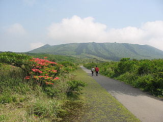
Mount Agung is an active volcano in Bali, Indonesia, southeast of Mount Batur volcano, also in Bali. It is the highest point on Bali, and dominates the surrounding area, influencing the climate, especially rainfall patterns. From a distance, the mountain appears to be perfectly conical. From the peak of the mountain, it is possible to see the peak of Mount Rinjani on the nearby island of Lombok, to the east, although both mountains are frequently covered in clouds. Agung is a stratovolcano, with a large and deep crater. Its most recent eruptions occurred from 2017–2019.

The Kelud is a mountain stratovolcano located in Kediri, East Java, Indonesia. Like many Indonesian volcanoes and others on the Pacific Ring of Fire, Kelud is known for large explosive eruptions throughout its history. More than 30 eruptions have occurred since 1000 AD. In 2007, an effusive explosion filled the crater with a lava dome. It last erupted on 13 February 2014, destroying the lava dome and ejecting boulders, stones and ashes up to West Java about 500 kilometres (310 mi) from Mount Kelud. The crater filled with water during the rainy season.

Taal Volcano is a large caldera filled by Taal Lake in the Philippines. Located in the province of Batangas about 50 kilometers (31 mi) south of Manila, the volcano is the second most active volcano in the country with 38 recorded historical eruptions, all of which were concentrated on Volcano Island, near the middle of Taal Lake. The caldera was formed by prehistoric eruptions between 140,000 and 5,380 BP.
Mount Mihara is an active volcano on the Japanese isle of Izu Ōshima. Although the volcano is predominantly basaltic, major eruptions have occurred at intervals of 100–150 years.

ʻEua is an island in the kingdom of Tonga. It is close to Tongatapu, but forms a separate administrative division. It has an area of 87.44 km2 (33.76 sq mi), and a population in 2021 of 4,903 people. The island leads in agriculture, tourism, and some of the forestry helps the island economically.

Fonuafo‘ou, formerly known as Falcon Island, is a submarine volcano in the western part of the Ha'apai group in Tonga. The volcano has created an island several times throughout history.

Mt Matavanu is an active volcano on the island of Savai'i in Samoa. The volcano was formed during an eruption in 1905. Lava flows from the eruption covered a large area of land in the Gaga'emauga district, leading to the relocation of several villages.
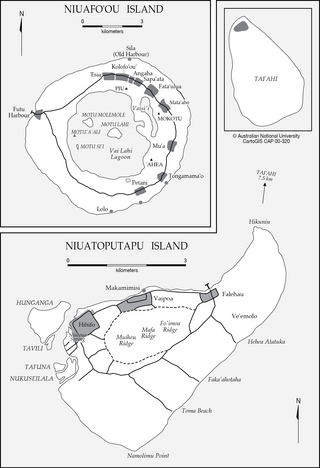
Niua is a division of the Kingdom of Tonga, namely the northernmost group of islands. It consists of three islands which together have an area of 71.69 km2 and a population of 1,150. The largest village is Hihifo on Niuatoputapu. Piu'o Tafahi is the highest point with an elevation of 560 m.
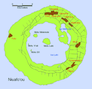
Vai Lahi is the central crater lake of the Tongan island of Niuafoʻou. The island is the most northerly island of Tonga, is the most northerly island in the kingdom of Tonga, and is located some 570 km north of the kingdom's main island, Tongatapu. Niuafoʻou is annular in shape, the rim of an active volcano. The island ring encloses two large lakes, Vai Lahi and the much smaller Vai Siʻi, plus some eight much smaller ponds.

The 2018 lower Puna eruption was a volcanic event on the island of Hawaiʻi, on Kīlauea volcano's East Rift Zone that began on May 3, 2018. It is related to the larger eruption of Kīlauea that began on January 3, 1983, though some volcanologists and USGS scientists have discussed whether to classify it as a new eruption. Outbreaks of lava fountains up to 300 feet (90 m) high, lava flows, and volcanic gas in the Leilani Estates subdivision were preceded by earthquakes and ground deformation that created cracks in the roads.

A volcanic crater lake is a lake in a crater that was formed by explosive activity or a collapse during a volcanic eruption.

La Soufrière, a stratovolcano on the Caribbean island of Saint Vincent in Saint Vincent and the Grenadines, began an effusive eruption on 27 December 2020. On 9 April 2021 there was an explosive eruption, and the volcano "continued to erupt explosively" over the following days, with pyroclastic flows. The activity pattern of the eruption was comparable to that of the event that occurred in 1902, which had a Volcanic Explosivity Index (VEI) of 4. The volcano is known to have erupted 23 times in the last 4,000 years, and had been dormant since 1979.

In early January 1951, a series of minor explosions and earthquakes rocked Mount Lamington, a volcano in Oro Province, Territory of Papua and New Guinea. Prior to the eruption, Mount Lamington was not recognized as a volcano due to the absence of historically-recorded eruptions and dense vegetation cover. From January 15, volcanic activity intensified, and tall eruption plumes were generated. The largest eruption occurred on the morning of January 21 when a thick black plume of ash rose 15,000 metres (50,000 ft) into the atmosphere. The eruption collapsed a lava dome and produced a lethal pyroclastic flow that killed 2,942 people. In the years after the eruption, new lava domes formed and collapsed in succession. Activity persisted until July 1956. The eruption is the deadliest natural disaster in Australian history, as the region was under the rule of the Government of Australia.
Angahā is a village on the island of ʻEua in Tonga. It is located on the western side of the island. The population is 364. The village was built in 1948 by people from Niuafoʻou who had been relocated to ʻEua after a volcanic eruption. It is named after Angahā, the chief village of Niuafoʻou.


