The Tonga Trench is an oceanic trench located in the southwestern Pacific Ocean. It is the deepest trench in the Southern hemisphere and the second deepest on Earth after the Mariana Trench. The fastest plate-tectonic velocity on Earth is occurring at this location, as the Pacific plate is being subducted westward in the trench.

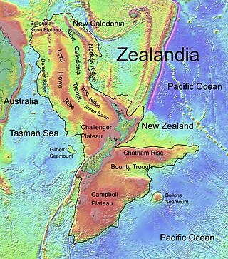
The Lord Howe Rise is a deep sea plateau which extends from south west of New Caledonia to the Challenger Plateau, west of New Zealand in the south west of the Pacific Ocean. To its west is the Tasman Basin and to the east is the New Caledonia Basin. Lord Howe Rise has a total area of about 1,500,000 km2 (580,000 sq mi), and generally lies about 750 to 1,200 metres under water. It is part of Zealandia, a much larger continent that is now mostly submerged, and so is composed of continental crust. Some have included the 3,500 m (11,500 ft) deep New Caledonia Basin as within the rise, given its continental crust origin, and this would give a larger total area of 1,950,000 km2 (750,000 sq mi).

The Kermadec Trench is a linear ocean trench in the south Pacific Ocean. It stretches about 1,000 km (620 mi) from the Louisville Seamount Chain in the north (26°S) to the Hikurangi Plateau in the south (37°S), north-east of New Zealand's North Island. Together with the Tonga Trench to the north, it forms the 2,000 km (1,200 mi)-long, near-linear Kermadec-Tonga subduction system, which began to evolve in the Eocene when the Pacific Plate started to subduct beneath the Australian Plate. Convergence rates along this subduction system are among the fastest on Earth, 80 mm (3.1 in)/yr in the north and 45 mm (1.8 in)/yr in the south.

The Norfolk Ridge is a long submarine ridge running between New Caledonia and New Zealand, about 1,300 km (810 mi) off the east-coast of Australia.

The 1,600 kilometres (990 mi) long Macquarie Fault Zone is a major right lateral-moving transform fault along the seafloor of the south Pacific Ocean which runs from New Zealand southwestward towards the Macquarie triple junction. It is also the tectonic plate boundary between the Australian plate to the northwest and the Pacific plate to the southeast. As such it is a region of high seismic activity and recorded the largest strike-slip event on record up to 23 May 1989, of at least 8.0

Zealandia, also known as Te Riu-a-Māui (Māori) or Tasmantis, is an almost entirely submerged mass of continental crust in Oceania that subsided after breaking away from Gondwana 83–79 million years ago. It has been described variously as a submerged continent, continental fragment, and microcontinent. The name and concept for Zealandia was proposed by Bruce Luyendyk in 1995, and satellite imagery shows it to be almost the size of Australia. A 2021 study suggests Zealandia is over a billion years old, about twice as old as geologists previously thought.

The Pacific Ocean evolved in the Mesozoic from the Panthalassic Ocean, which had formed when Rodinia rifted apart around 750 Ma. The first ocean floor which is part of the current Pacific plate began 160 Ma to the west of the central Pacific and subsequently developed into the largest oceanic plate on Earth.
Maria Seton is an Australian geologist in the Faculty of Science EarthByte Group School of Geosciences at the University of Sydney. Seton's research is in the field of geophysics and geodynamics. Her main focus is the link between plate tectonic and mantle processes. Seton also works on kinematic controls on subduction and back-arc basin formation and the relationship between tectonics and palaeo-climate.

The North Fiji Basin (NFB) is an oceanic basin west of Fiji in the south-west Pacific Ocean. It is an actively spreading back-arc basin delimited by the Fiji islands to the east, the inactive Vitiaz Trench to the north, the Vanuatu/New Hebrides island arc to the west, and the Hunter Fracture Zone to the south. Roughly triangular in shape with its apex located at the northern end of the New Hebrides Arc, the basin is actively spreading southward and is characterised by three spreading centres and an oceanic crust younger than 12 Ma. The opening of the NFB began when a slab roll-back was initiated beneath the New Hebrides and the island arc started its clockwise rotation. The opening of the basin was the result of the collision between the Ontong Java Plateau and the Australian plate along the now inactive Solomon–Vitiaz subduction system north of the NFB. The NFB is the largest and most developed back-arc basin of the south-west Pacific. It is opening in a complex geological setting between two oppositely verging subduction systems, the New Hebrides/Vanuatu and Tonga trenches and hence its ocean floor has the World's largest amount of spreading centres per area.

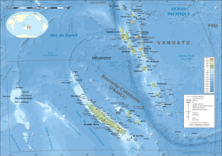
The d'EntrecasteauxRidge (DER) is a double oceanic ridge in the south-west Pacific Ocean, north of New Caledonia and west of Vanuatu Islands. It forms the northern extension of the New Caledonia–Loyalty Islands arc, and is now actively subducting in the Vanuatu subduction zone under the Vanuatu/New Hebrides arc. The subduction of the DER is responsible for the anomalous morphology of the central part of New Hebrides arc whose movement more closely matches the north-east direction of the subducting Australian Plate.

The geology of New Caledonia includes all major rock types, which here range in age from ~290 million years old (Ma) to recent. Their formation is driven by alternate plate collisions and rifting. The mantle-derived Eocene Peridotite Nappe is the most significant and widespread unit. The igneous unit consists of ore-rich ultramafic rocks thrust onto the main island. Mining of valuable metals from this unit has been an economical pillar of New Caledonia for more than a century.

The New Hebrides Trench is an oceanic trench which is over 7.1 km (4.4 mi) deep in the Southern Pacific Ocean. It lies to the northeast of New Caledonia and the Loyalty Islands, to the southwest of Vanuatu, east of Australia, and south of Papua New Guinea and the Solomon Islands. The trench was formed as a result of a subduction zone. The Australian Plate is being subducted under the New Hebrides Plate causing volcanism which produced the Vanuatu archipelago.

Zealandia is an area of mostly submerged continental crust that contains New Zealand and New Caledonia.

The Three Kings Ridge, sometimes known as Three Kings Rise and more rarely at its southern end as the Three Kings Bank is a deep sea westward facing volcanic arc of Zealandia continental crust extending from 55 kilometres (34 mi) northwest of Cape Reinga / Te Rerenga Wairua, New Zealand on a line bisecting New Caledonia and Fiji in the South Pacific Ocean. Its southern portion contains the Manawatāwhi / Three Kings Islands which have biological significance as they are host to unique species and important marine ecosystems.

The Wishbone scarp is a Pacific Ocean floor feature in the oceanic crust, that if it were on land would be similar to a mountain range fault system over 1,000 km (620 mi) long. It commences in the north near the Osbourn Trough although it is likely to be related tectonically to the Manihiki scarp somewhat to its north. To the south it splits into west and east scarps that have been intercepted by the Louisville hotspot with the West Wishbone scarp continuing until it intercepts the Chatham Rise. There is now evidence that the entire scarp has a fracture zone origin resolving previous uncertainty on this issue.

The Havre Trough is a currently actively rifting back-arc basin about 100 km (62 mi) to 120 km (75 mi) wide, between the Australian Plate and Kermadec microplate. The trough extends northward from New Zealand's offshore Taupō Volcanic Zone commencing at Zealandia's continental shelf margin and continuing as a tectonic feature, as the Lau Basin which currently contains active seafloor spreading centers. Its eastern margin is defined by the Kermadec Ridge created by Pacific Plate subduction under the Kermadec microplate, while the western margin is the remnant Lau-Colville Ridge.

The South Fiji Basin is a large 4 to 4.7 km deep oceanic basin in the south-west Pacific Ocean, south of Fiji. It was formed from the then Indo-Australian Plate and is delimited to the north west by the New Hebrides Trench, and the Hunter Fracture Zone, to the west by the Three Kings Ridge, to the east by the Lau-Colville Ridge, and to the south by the continental shelf of Zealandia.
The Vanuatu subduction zone is currently one of the most active subduction zones on Earth, producing great earthquakes, with potential for tsunami hazard to all coastlines of the Pacific Ocean. There are active volcanoes associated with arc volcanism.

The Hunter Ridge, is an active volcanic arc oceanic ridge located on the oceanic New Hebrides Plate in the south-west Pacific Ocean extending at least 550 km (340 mi). It defines the south-western limit of the North Fiji Basin (NFB) and is an area of unique range in volcanic geochemistry, which transpires to have been due partially to a new, previously unrecognised, subduction zone.

The New Caledonia Trough is an ocean floor feature that extends 2,300 km (1,400 mi) from the north of the island of Grande Terre of New Caledonia, to the coast off the Taranaki region of the North Island of New Zealand. Its southern portion includes the Taranaki Basin which has demonstrated oil reserves.


