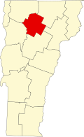
North Hyde Park, Vermont

Last updated

North Hyde Park, Vermont
USA Vermont relief location map.svg
Red pog.svg
North Hyde Park
Usa edcp relief location map.png
Red pog.svg
North Hyde Park
Coordinates: 44°40′14″N72°35′53″W / 44.67056°N 72.59806°W / 44.67056; -72.59806
Country United States
State Vermont
County Lamoille
Towns Hyde Park, Johnson, Eden
Area
[1]
  Total
2.78 sq mi (7.19 km2)
  Land2.75 sq mi (7.13 km2)
  Water0.03 sq mi (0.07 km2)
Elevation
873 ft (266 m)
Time zone UTC-5 (Eastern (EST))
  Summer (DST) UTC-4 (EDT)
ZIP Codes
05665 (Hyde Park)
05656 (Johnson)
05652 (Eden)
Area code 802
FIPS code 50-50725
GNIS feature ID1458745 [2]

North Hyde Park is an unincorporated village and census-designated place (CDP) in the towns of Hyde Park and Johnson, Lamoille County, Vermont, United States. The CDP was first drawn for the 2020 census. North Hyde Park has a post office with ZIP code 05665, which opened on May 29, 1839. [3] [4]

Geography

The community is located along Vermont Route 100 and the Gihon River 6 miles (10 km) north of the village of Hyde Park. Via Vermont Route 100C, it is 5 miles (8 km) northeast of the village of Johnson.

According to the U.S. Census Bureau, the North Hyde Park CDP has a total area of 2.8 square miles (7.2 km2), of which 0.03 square miles (0.07 km2), or 0.92%, are water. [1] Portions of the CDP extend west into the town of Johnson and north into the town of Eden. Via the Gihon River, the community is part of the Lamoille River watershed, flowing west to Lake Champlain.

Related Research Articles

<span class="mw-page-title-main">Lamoille County, Vermont</span> County in Vermont, United States

Lamoille County is a county located in the U.S. state of Vermont. As of the 2020 census, the population was 25,945, and it is the third-least populous county in Vermont. Its shire town is the town of Hyde Park, while Morristown is the county's largest town by population as well as its main commercial center. The county was created in 1835 from portions of Orleans, Franklin, Washington, and Chittenden Counties and organized the following year.

<span class="mw-page-title-main">Montgomery, Vermont</span> Town in Vermont, United States

Montgomery is a town in Franklin County, Vermont, United States. The population as of the 2020 census was 1,184. In 1963, part of Avery's Gore in Franklin County became part of Montgomery, with the other section becoming part of Belvidere in Lamoille County.

<span class="mw-page-title-main">Eden, Vermont</span> Town in Vermont, United States

Eden is a town in Lamoille County, Vermont, United States. The population was 1,338 at the 2020 census.

<span class="mw-page-title-main">Morristown, Vermont</span> Town in Vermont, United States

Morristown is a town in Lamoille County, Vermont, United States. As of the 2020 census, the population was 5,434. Morristown is the largest town by population in Lamoille County, and its central village of Morrisville serves as the county's main commercial center.

<span class="mw-page-title-main">Milton (CDP), Vermont</span> Census-designated place in Vermont, United States

Milton is an unincorporated village within the town of Milton in Chittenden County, Vermont, United States. The village disincorporated in 2003 and became a census-designated place (CDP) in 2008. As of the 2020 census the population was 3,804, out of a population of 10,723 for the entire town.

<span class="mw-page-title-main">Cambridge, Vermont</span> Town in Vermont, United States

Cambridge is a town in Lamoille County, Vermont, United States. The population was 3,839 at the 2020 United States Census. Cambridge includes the villages of Jeffersonville and Cambridge.

<span class="mw-page-title-main">Hyde Park (town), Vermont</span> Town in Vermont, United States

Hyde Park is a town in and the shire town of Lamoille County, Vermont, United States. The town was named for Captain Jedediah Hyde, an early landowner who was a veteran of the American Revolutionary War. The population was 3,020 at the 2020 census. There is also a village of the same name within the town.

<span class="mw-page-title-main">Johnson, Vermont</span> Town in Vermont, United States

Johnson is a town in Lamoille County, Vermont, United States. The population was 3,491 at the 2020 census. The town is home to Northern Vermont University-Johnson, a part the Vermont State Colleges system. The Vermont Studio Center is located in the village of Johnson. Since 1842, the town has been the home to Johnson Woolen Mills.

<span class="mw-page-title-main">Ledgewood, New Jersey</span> Populated place in Morris County, New Jersey, US

Ledgewood is an unincorporated community and census-designated place (CDP) in Roxbury Township, Morris County, New Jersey, United States. It was historically known as Drakesville after Abraham Drake, originally from Piscataway, New Jersey, who operated a mill and tavern here in the mid-1700s. The community was located on the Morris Canal. The name changed to Ledgewood on January 1, 1892.

Earling is an unincorporated community and census-designated place (CDP) in Logan County, West Virginia, United States. It was first listed as a CDP prior to the 2020 census. The Earling post office closed on July 1, 1989. The town now shares ZIP Code 25632 with Lyburn and Taplin.

Horse Shoe is an unincorporated community and census-designated place (CDP) in Henderson County, North Carolina, United States. Its ZIP code is 28742. As of the 2010 census, its population was 2,351.

<span class="mw-page-title-main">Canaan (CDP), Vermont</span> Census-designated place in Vermont, United States

Canaan is a census-designated place comprising the main settlement in the town of Canaan, Essex County, Vermont, United States. As of the 2010 census, it had a population of 392, out of a total town population of 972.

<span class="mw-page-title-main">Concord (CDP), Vermont</span> Census-designated place in Vermont, United States

Concord is a census-designated place comprising the main settlement in the town of Concord, Essex County, Vermont, United States. As of the 2010 census, it had a population of 271, out of a total town population of 1,235. It was an incorporated village for much of the 20th century, disincorporating in 1969.

<span class="mw-page-title-main">Richford (CDP), Vermont</span> Census-designated place in Vermont, United States

Richford is a census-designated place comprising the main settlement in the town of Richford, Franklin County, Vermont, United States. Its population was 1,361 as of the 2010 census, out of 2,308 people in the entire town of Richford.

Stowe is a census-designated place (CDP) comprising the central community in the town of Stowe, Lamoille County, Vermont, United States. As of the 2010 census the population of the CDP was 495, out of 4,314 in the entire town.

Watrous is an unincorporated community and census-designated place (CDP) in Mora County, New Mexico, United States. Its population was 99 as of the 2020 census, down from 135 in 2010. Watrous has a post office with ZIP code 87753, which opened on April 14, 1868. The community is located along Interstate 25. It was named after merchant and landowner Samuel Watrous, who moved to New Mexico from Vermont in 1835.

Linwood is a hamlet and census-designated place (CDP) in the town of York, Livingston County, New York, United States. Its population was 74 as of the 2010 census. Linwood had a post office until February 6, 1993; it still has its own ZIP code, 14486.

Livonia Center is a hamlet and census-designated place (CDP) in the town of Livonia, Livingston County, New York, United States. Its population was 421 as of the 2010 census. Livonia Center has a post office with ZIP code 14488, which opened on April 9, 1811.

South Lima is a hamlet and census-designated place (CDP) in Livingston County, New York, United States. Its population was 240 as of the 2010 census. South Lima had a post office from January 10, 1854, until April 17, 2010; it still has its own ZIP code, 14558.

Wolcott is a census-designated place (CDP) comprising the central community in the town of Wolcott, Lamoille County, Vermont, United States. The CDP was first drawn for the 2020 census.

References

  1. 1 2 "2020 U.S. Gazetteer Files: Vermont". United States Census Bureau. Retrieved February 11, 2021.
  2. "North Hyde Park". Geographic Names Information System . United States Geological Survey, United States Department of the Interior.
  3. United States Postal Service. "USPS - Look Up a ZIP Code" . Retrieved May 20, 2017.
  4. "Postmaster Finder - Post Offices by ZIP Code". United States Postal Service . Retrieved May 20, 2017.