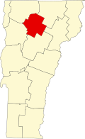
Johnson (village), Vermont

Last updated
Johnson, Vermont
USA Vermont location map.svg
Red pog.svg
Johnson
Location in Vermont
Usa edcp location map.svg
Red pog.svg
Johnson
Location in the United States
Coordinates: 44°38′10″N72°40′52″W / 44.63611°N 72.68111°W / 44.63611; -72.68111 Coordinates: 44°38′10″N72°40′52″W / 44.63611°N 72.68111°W / 44.63611; -72.68111
Country United States
State Vermont
County Lamoille
Town Johnson
Area
[1]
  Total1.22 sq mi (3.16 km2)
  Land1.17 sq mi (3.02 km2)
  Water0.05 sq mi (0.14 km2)
Elevation
502 ft (153 m)
Population
 (2020)
  Total1,332
  Density1,100/sq mi (420/km2)
Time zone UTC-5 (Eastern (EST))
  Summer (DST) UTC-4 (EDT)
ZIP code
05656
Area code(s) 802
FIPS code 50-37000 [2]
GNIS feature ID1458021 [3]

Johnson is a village in the town of Johnson in Lamoille County, Vermont, United States. The population was 1,332 at the 2020 census. [4]

Contents

Geography

According to the United States Census Bureau, the village has a total area of 1.2 square miles (3.2 km2), all land.

Demographics

Historical population
CensusPop.
1900 587
1910 65110.9%
1920 6814.6%
1930 659−3.2%
1940 75314.3%
1950 90019.5%
1960 9414.6%
1970 1,29637.7%
1980 1,3937.5%
1990 1,4705.5%
2000 1,420−3.4%
2010 1,4431.6%
2020 1,332−7.7%
U.S. Decennial Census [5]

As of the census [2] of 2000, there were 1,420 people, 469 households, and 186 families residing in the village. The population density was 1,166.9 people per square mile (449.4/km2). There were 494 housing units at an average density of 406.0/sq mi (156.3/km2). The racial makeup of the village was 95.63% White, 0.92% Black or African American, 0.07% Native American, 1.34% Asian, 0.28% from other races, and 1.76% from two or more races. Hispanic or Latino of any race were 1.06% of the population.

There were 469 households, out of which 20.9% had children under the age of 18 living with them, 25.6% were married couples living together, 10.9% had a female householder with no husband present, and 60.3% were non-families. 39.4% of all households were made up of individuals, and 12.6% had someone living alone who was 65 years of age or older. The average household size was 2.11 and the average family size was 2.88.

In the village, the population was spread out, with 13.2% under the age of 18, 46.4% from 18 to 24, 20.1% from 25 to 44, 11.9% from 45 to 64, and 8.4% who were 65 years of age or older. The median age was 22 years. For every 100 females, there were 99.7 males. For every 100 females age 18 and over, there were 100.8 males.

The median income for a household in the village was $23,846, and the median income for a family was $40,089. Males had a median income of $25,104 versus $19,861 for females. The per capita income for the village was $11,651. About 8.3% of families and 23.6% of the population were below the poverty line, including 18.8% of those under age 18 and 15.4% of those age 65 or over.

Related Research Articles

Pewamo, Michigan Village in Michigan, United States

Pewamo is a village in Lyons Township, Ionia County in the U.S. state of Michigan. It was founded in 1857 as a station along the Detroit, Grand Haven and Milwaukee Railway. The village name was suggested by J.C. Blanchard in honor of Chief Pewamo, with whom he had hunted along the nearby Grand River. The population was 469 at the 2010 census.

Ashley, Ohio Village in Ohio, United States

Ashley is a village in Delaware County, Ohio, United States. The population was 1,330 at the 2010 census.

St. Louisville, Ohio Village in Ohio, United States

St. Louisville is a village in Licking County, Ohio, United States, along the North Fork of the Licking River. The population was 373 at the 2010 census.

Prospect, Ohio Village in Ohio, United States

Prospect is a village in Marion County, Ohio, United States. The population was 1,112 at the 2010 census. The village is served by Elgin Local School District. Prospect has a public library, a branch of Marion Public Library.

Sunrise Beach Village, Texas City in Texas, United States

Sunrise Beach Village is a city in Llano County, Texas, United States. The village was established in 1973. The population was 713 at the 2010 census.

Lemington, Vermont Town in Vermont, United States

Lemington is a town in Essex County, Vermont, United States. The population was 104 as of the 2010 census. It is part of the Berlin, NH–VT Micropolitan Statistical Area.

Derby Center, Vermont Village in Vermont, United States

Derby Center is a village in the town of Derby, Orleans County, Vermont, United States. The population was 635 at the 2020 census.

East Montpelier, Vermont Town in Vermont, United States

East Montpelier is a town in Washington County, Vermont, United States. The population was 2,576 at the 2010 census.

Jacksonville, Vermont Village in Vermont, United States

Jacksonville is a village in the town of Whitingham, Windham County, Vermont, United States. The population was 213 at the 2020 census.

North Westminster, Vermont CDP in Vermont, United States

North Westminster is a census-designated place (CDP) in Windham County, Vermont, United States. The population was 262 at the 2020 census. Formerly an incorporated village, it surrendered its charter on April 20, 2010 and reverted to the town of Westminster. The village area and additional surroundings were defined by the U.S. Census Bureau as a CDP in 2012.

Perkinsville, Vermont Village in Vermont, United States

Perkinsville is a village located in the town of Weathersfield, Windsor County, Vermont, United States. The population was 108 at the 2020 census.

Manchester (village), Vermont Village in Vermont, United States

Manchester is an incorporated village in the town of Manchester, Bennington County, Vermont, United States. The population was 783 at the 2020 census.

Cambridge (village), Vermont Village in Vermont, United States

Cambridge is a village in the town of Cambridge, Lamoille County, Vermont, United States. The population was 210 at the 2020 census.

Hyde Park (village), Vermont Village in Vermont, United States

Hyde Park is a village in the town of Hyde Park, Lamoille County, Vermont, United States. The village population was 410 at the 2020 census.

Johnson, Vermont Town. in Vermont, United States

Johnson is a town in Lamoille County, Vermont, United States. The population was 3,446 at the 2010 census. The town is home to Northern Vermont University-Johnson, a part the Vermont State Colleges system. The Vermont Studio Center is located in the village of Johnson.

Albany (village), Vermont Village in Vermont, United States

Albany is a village in the town of Albany in Orleans County, Vermont, United States. The population was 166 at the 2020 census.

Wallingford, Vermont Town in Vermont, United States

Wallingford is a town in Rutland County, Vermont, United States. The population was 2,079 at the 2010 census. Wallingford also contains the villages of East Wallingford and South Wallingford.

Marshfield (village), Vermont Village in Vermont, United States

Marshfield is a village in the town of Marshfield in Washington County, Vermont, United States. The population was 229 at the 2020 census.

Waterbury (CDP), Vermont Census-designated place in Vermont, United States

Waterbury is an unincorporated village and census-designated place (CDP) in the town of Waterbury, Washington County, Vermont, United States. The population was 1,897 at the 2020 census. The former village of Waterbury was dissolved in 2017, and its governmental functions were merged with the town of Waterbury.

Windsor, Wisconsin Village in Wisconsin, United States

Windsor is a village and former town in Dane County, Wisconsin, United States. The population was 8,754 at the 2020 census. The communities of Lake Windsor, Morrisonville, and Token Creek are located within the village. Windsor voted to incorporate as a village on November 3, 2015; prior to its incorporation, it was a town, and a portion of the town was a census-designated place. Windsor is a part of the Census Bureau's Madison metropolitan statistical area.

References

  1. "2019 U.S. Gazetteer Files". United States Census Bureau. Retrieved August 7, 2020.
  2. 1 2 "U.S. Census website". United States Census Bureau . Retrieved 2008-01-31.
  3. "US Board on Geographic Names". United States Geological Survey. 2007-10-25. Retrieved 2008-01-31.
  4. "Census - Geography Profile: Johnson village, Vermont". United States Census Bureau . Retrieved December 26, 2021.
  5. "Census of Population and Housing". Census.gov. Retrieved 2015-06-04.