
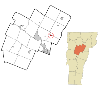
Morristown is a town in Lamoille County, Vermont, United States. As of the 2020 census, the population was 5,434. Morristown is the largest town by population in Lamoille County, and its central village of Morrisville serves as the county's main commercial center.
Hanover is a census-designated place (CDP) and the main village in the town of Hanover in Grafton County, New Hampshire, United States. The population of the CDP was 9,078 at the 2020 census, out of 11,870 in the entire town. The CDP includes the campus of Dartmouth College.

Charlestown is a census-designated place (CDP) and the main village in the town of Charlestown, Sullivan County, New Hampshire, United States. The population of the CDP was 1,078 at the 2020 census, out of 4,806 in the entire town.

Smoketown is an unincorporated village and census-designated place (CDP) in East Lampeter Township, Lancaster County, Pennsylvania, United States. Also known as Smoke Town, it is served by the Smoketown Airport. As of the 2010 census, it had a population of 357.

Bristol is the main settlement in the town of Bristol in Addison County, Vermont, United States, and a census-designated place (CDP). The population was 1,936 at the 2020 census, out of a total population of 3,782 in the town of Bristol.
Waterbury Center is an unincorporated village and census-designated place (CDP) in the town of Waterbury, Washington County, Vermont, United States. As of the 2020 census, it had a population of 390.

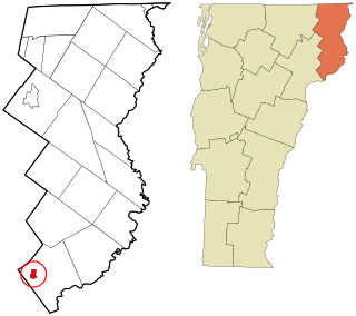
Colebrook is a census-designated place (CDP) and the main village in the town of Colebrook, Coös County, New Hampshire, United States. The population of the CDP was 1,201 at the 2020 census, out of 2,084 in the entire town. The CDP population had dropped from 1,394 at the 2010 census.

North Walpole is a census-designated place (CDP) in the town of Walpole in Cheshire County, New Hampshire, United States. It had a population of 785 at the 2020 census, making it the largest village in the town of Walpole.

East Montpelier is a census-designated place (CDP) comprising the central village of the town of East Montpelier, Washington County, Vermont, United States. The population of the CDP was 80 at the 2010 census.
Plainfield is a census-designated place (CDP) comprising the main village of the town of Plainfield, Washington County, Vermont, United States. The population of the CDP was 401 at the 2010 census.

Waitsfield is a census-designated place (CDP) in the town of Waitsfield, Washington County, Vermont, United States. The population of the CDP was 164 at the 2010 census.

Worcester is a census-designated place (CDP) that comprises the main village in the town of Worcester, Washington County, Vermont, United States. The population of the CDP was 112 at the 2010 census.
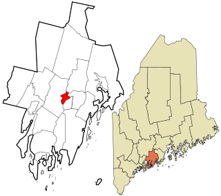
Blue Hill is a census-designated place (CDP) in the town of Blue Hill in Hancock County, Maine, United States. The CDP population was 943 as per the 2010 census, out of a population of 2,686 in the town of Blue Hill as a whole.
Castine is a census-designated place (CDP) in the town of Castine in Hancock County, Maine, United States. The CDP population was 1,029 at the 2010 census, out of 1,366 people in the town as a whole.
Newcastle is a census-designated place (CDP) comprising the main village of the town of Newcastle in Lincoln County, Maine, United States. The population was 667 at the 2010 census, out of 1,752 in the entire town. In the 2000 census, the village was part of the Damariscotta-Newcastle CDP.
Concord is a census-designated place comprising the main settlement in the town of Concord, Essex County, Vermont, United States. As of the 2010 census, it had a population of 271, out of a total town population of 1,235. It was an incorporated village for much of the 20th century, disincorporating in 1969.
Russell is a census-designated place that comprises the populated center of the town of Russell in Hampden County, Massachusetts, United States. The population of the CDP was 786 at the 2010 census, out of 1,775 in the entire town of Russell. It is part of the Springfield, Massachusetts Metropolitan Statistical Area.

Huntington is a census-designated place (CDP) comprising the main village in the town of Huntington in Hampshire County, Massachusetts, United States. The population of the CDP was 936 at the 2010 census, out of a total town population of 2,180. It is part of the Springfield, Massachusetts Metropolitan Statistical Area.
North Hyde Park is an unincorporated village and census-designated place (CDP) in the towns of Hyde Park and Johnson, Lamoille County, Vermont, United States. The CDP was first drawn for the 2020 census. North Hyde Park has a post office with ZIP code 05665, which opened on May 29, 1839.
Wolcott is a census-designated place (CDP) comprising the central community in the town of Wolcott, Lamoille County, Vermont, United States. The CDP was first drawn for the 2020 census.


