
Dorchester County is a county located in the U.S. state of South Carolina. As of the 2020 census, the population was 161,540. Its county seat is St. George.
Summerville is a town in the U.S. state of South Carolina situated mostly in Dorchester County, with small portions in Berkeley and Charleston counties. It is part of the Charleston-North Charleston-Summerville Metropolitan Statistical Area. Summerville's population at the 2020 census was 50,915.

The 1886 Charleston earthquake occurred about 9:50 p.m. local time August 31. It caused 60 deaths and $5–6 million in damage to 2,000 buildings in the Southeastern United States. It is one of the most powerful and damaging earthquakes to hit the East Coast of the United States.
Dorchester was a town in the Province of South Carolina. Situated on the Ashley River about 18 miles (29 km) from Charleston, it was founded in February 1696 by followers of Reverend Joseph Lord from Dorchester, Massachusetts.

South Carolina Highway 61 (SC 61) is a 67-mile-long (108 km) state highway in the U.S. state of South Carolina. The highway is designated on a north–south direction, but physically travels in an east–west direction, from SC 30 in Charleston to U.S. Route 78 (US 78) near Branchville. The portion of SC 61 from Church Creek Bridge and 10 miles (16 km) north is designated a National Scenic Byway.

Ashley River Historic District is a historic district located west of the Ashley in the South Carolina Lowcountry near Charleston, South Carolina, United States. The Historic District includes land from five municipalities, almost equally split between Charleston and Dorchester counties. The district includes dry land, swamps, and marshes of the Rantowles Creek and Stono Swamp watershed.

Indian Field Methodist Campground is a camp meeting site for the Methodist Church in Dorchester County, South Carolina. It is on SC Route S-18-73, off US Route 15, about 5 mi (8 km) north of Saint George. Indian Field was built in 1848 and has been a site for religious gatherings for over 160 years. It is associated with the Indian Field United Methodist Church located on U.S. Highway 15 about 2 miles (3 km) north of the campground and just south of U.S. Highway 178. It was named a historic district of the National Register of Historic Places on March 30, 1973.

This is a list of the National Register of Historic Places listings in Jasper County, South Carolina.

Appleby's Methodist Church is a historic Methodist church located near St. George, Dorchester County, South Carolina. It was probably built about 1840–1850, and is a one-story, wooden meeting house in the Greek Revival style. The building is clapboard and the medium gable roof is covered with asphalt shingles. Also on the property is a contributing late 19th-century cemetery.

Cypress Methodist Camp Ground is a historic Methodist camp meeting in Ridgeville, Dorchester County, South Carolina. Cypress Camp Ground was functional as early as 1794, and an adjacent cemetery contains graves from the early 1800s. The campground is in the general shape of a rectangle of 34 tents, or cabins, made of rough-hewn lumber. These cabins, rectangular shaped, are generally 1 1/2-stories and contain earthen floors.

Mount Carmel A.M.E. Zion Church & Campground is a historic African Methodist Episcopal Zion camp meeting grounds in Heath Springs, South Carolina, Lancaster County, South Carolina. It was established in 1866 and consists of a complex of approximately 55 small "cabins" or "tents" and the brick church of Mt. Carmel A.M.E. Zion Church is located in the general form of a rectangle. Mount Carmel A.M.E Zion Church Campmeeting starts every year on the first Wednesday in September, and last for 4–5 days. An "arbor," or open-air structure, is located in the center of the complex, where music, gospel singing, praise and worship, preaching and teachings are held. People come to worship, fellowship, network, and eat food from as far as New York City, NY to Orlando, FL. There is also a section on the grounds for vendors. The majority of the cabins are small frame, some are two story cabins for larger families made from concrete block and wooden structures. Also on the property is the church cemetery.

Colonial Dorchester State Historic Site sits along the Ashley River, near the town of Summerville in Dorchester County, South Carolina. In 1969, the site was donated to the South Carolina State Park Service and was added to the National Register of Historic Places on December 2, 1969. Currently the site of a 325-acre park, Old Dorchester State Park offers visitors a glimpse into South Carolina's Colonial past. The park boasts one of the most well-preserved oyster-shell tabby forts in the country, St. George's Bell Tower, log shipping wharves, burial sites and cemeteries, as well as on-going archaeological digs that are still unearthing the settlement's history.

Old Pine Church, also historically known as Mill Church, Nicholas Church, and Pine Church, is a mid-19th century church located near to Purgitsville, West Virginia, United States. It is among the earliest extant log churches in Hampshire County, along with Capon Chapel and Mount Bethel Church.

St. Paul Camp Ground, also known as St. Paul A.M.E. Camp Ground, is a historic African Methodist Episcopal camp meeting and national historic district located near Harleyville, Dorchester County, South Carolina. The district encompasses 43 contributing buildings. It was established about 1880, and the buildings and grounds are used for one week each year. The tabernacle is a one-story building clad in rough-sawn weatherboard. Also on the property are 54 tents, two stores, and a storage house.
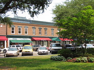
Summerville Historic District is a national historic district located at Summerville, Dorchester County, South Carolina. The district encompasses 700 contributing buildings in the village of Summerville. About 70 percent of the buildings predate World War I. The buildings include raised cottages, Greek Revival influenced, and Victorian / Queen Anne and other turn of the 20th century structures are found throughout. In addition to residential structures, the district includes churches and commercial buildings—most dating from around 1900. Notable buildings include Tupper's Drug Store, O. J. Sire's Commercial Building, White Gables, Pettigru-Lebby House Gazebo, Summerville Presbyterian Church, Wesley United Methodist Church, and the Squirrel Inn.
Carroll Place, also known as Old Carroll Place, is a historic plantation house located near St. George, Dorchester County, South Carolina.
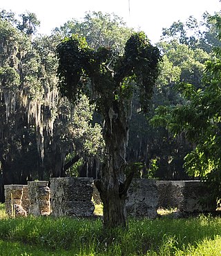
Newington Plantation is a historic archaeological site located near Stallsville, Dorchester County, South Carolina. The plantation was originally settled in the early or middle 1680s. Newington includes the remains of a series of house forms as they developed from an early single timber and clay structure destroyed sometime around the Yamasee War in 1715 to the fine, large brick structure built by Joseph Blake. The plantation included terraced gardens, a reflecting pool, brick outbuildings, and the main house. The house burned in 1845, and the ruins stood until 1876, when an attempt made to salvage the bricks failed. After years under the plow, many of the ruins on the surface have disappeared and the ornamental lake has silted and gone to ruin.

Camp Welfare is a historic African-American religious campground located near Monticello, Fairfield County, South Carolina. It was founded after the American Civil War by the African Methodist Episcopal Zion Church. It is a collection of approximately 100 one-story, frame, weatherboarded cabins called tents arranged in a double "U"-shape. The focal point of the camp is the arbor; a rough, gable roofed wooden shelter with wooden benches. Also located at the camp is Zion Church; a frame building with a gable roof surmounted by a belfry built about 1930.
White Hall Plantation House Ruins and Oak Avenue is a historic plantation site located near Ridgeland, Jasper County, South Carolina. The site consists of the ruins of a brick house with tabby wings and twin tabby flanking outbuildings; a tabby retaining wall; and a massive double avenue of oaks planted in the late-18th or early-19th century. The plantation house was built between 1771 and 1776, then enlarged between 1786 and 1791. The house at White Hall burned about 1870 and was not renovated or occupied afterward.
Cattle Creek Campground, also known as Cattle Creek United Methodist Church and Campground, is a historic camp meeting ground that is now a national historic district located near Rowesville, Orangeburg County, South Carolina. The district encompasses 37 contributing buildings and 1 contributing site. It was founded in 1786, although this date has been challenged. The campground burned in 1898 and was rebuilt. Another fire in 2017 destroyed 15 "tents," which were again rebuilt. It includes 36 cabins, called “tents,” arranged in a wide semi-circle. They are located around an open, 56 feet by 81 feet, pavilion structure known as the “stand” or “tabernacle.” Also located on the property is a cemetery. It is one of three remaining Methodist campgrounds in South Carolina.


