Omuma Local Government

Last updated

Omuma
LGA
Nigeria location map.svg
Red pog.svg
Omuma
Africa location map.svg
Red pog.svg
Omuma
Coordinates: 5°5′12″N7°13′59″E / 5.08667°N 7.23306°E
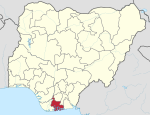
 / 5.08667; 7.23306
Country Nigeria
State Rivers State
Date createdOctober 1, 1996[ citation needed ]
SeatEberi
Government
  Local Government ChairmanNwaiwu Chisorom (PDP)
  Deputy Local Government ChairmanUbani Mary (PDP)
  Local Government CouncilWard 1: Umesi Obioma (PDP)
Ward 2: Promise Reginald (PDP)
Ward 3: Ekpendu Prince Eze (PDP)
Ward 4: Elike Nwaobia Samuel (PDP)
Ward 5: Henry Okechukwu (PDP)
Ward 6: Ugochukwu Orji (PDP)
Ward 7: Cyril Oluo (PDP)
Ward 8: Nwaodu Nnanyibu (PDP)
Ward 9: Onyebuchi Onyeche (PDP)
Ward 10: Okpoko Lucky (PDP)
Area
  Total70 sq mi (170 km2)
Time zone UTC+1 (WAT)
Omuma Local Government

Omuma is a Local Government Area in Rivers State, South South geopolitical zone of Nigeria. [1] Its headquarters are in the town of Eberi. Its people are Igbo . [2] It was created in the year 1989.

It has an area of 170 km2 (66 sq mi) and a population of 100,366 at the 2006 census [ citation needed ].

The postal code of the area is 512. [3] [4] The local government area is made up of several towns and villages such as Umuabali, Umuroke, Eberi, Egbelu, Umuokwa, Umuoroyo and Umudik. A number of festival such as the Ogwu Ekpeye festival are held in omuma local government area. [1] Christianity is widely practiced in Omuma local government area. With the average humidity level of 78 percent in the LGA, it hosts a number of Rivers and tributaries. [1] it's has a vibrant trade sector and hosts a number of markets such as the Eketa market where a variety of commodities are bought and sold. [1] Omuma local government area is also an agricultural hub with crops such as yam, maize, Palm oil and vegetables. [1] Other economic activities engaged in by the people include fishing, crafts making, lumbering and hunting. [1]

Related Research Articles

<span class="mw-page-title-main">Rivers State</span> State of Nigeria

Rivers State, also known as Rivers, is a state in the Niger Delta region of southern Nigeria. Formed in 1967, when it was split from the former Eastern Region, Rivers State borders include: Imo to the north, Abia and Akwa Ibom to the east, and Bayelsa and Delta to the west. The state capital, Port Harcourt, is a metropolis that is considered to be the commercial center of the Nigerian oil industry.

Idah is a town in Kogi State, Nigeria, on the eastern bank of the Niger River in the middle belt region of Nigeria. It is the headquarter of the Igala Kingdom, and also a Local Government Area with an area of 36 km2. Idah had a population of 79,815 at the 2006 census.

<span class="mw-page-title-main">Orlu, Imo</span> LGA and city in Imo, Nigeria

Orlu is the second-largest city in South East, Imo State, Nigeria, with a population of 420,600. It has a long history as the headquarters for the Organisation of African Unity (OAU) and humanitarian relief agencies during the Nigeria-Biafra Civil War. The city houses the Nigerian headquarters of the British Cheshire Home. It is the second most developed city after Owerri in Imo state.

<span class="mw-page-title-main">Oguta</span> Local Government Area in Imo State, Nigeria

Oguta is a town on the east bank of Oguta Lake in Imo State of southeastern Nigeria.

Boki is a Local Government Area in the Cross River State of Nigeria. It was created on 28 August 1991, and its capital is Boje. The region has a contiguous border with the Republic of Cameroon and is known internationally as a commercial centre for agricultural commodities such as cocoa, coffee, timber, and palm products.

Yala is a Local Government Area in Cross River State, Nigeria. Its headquarters is in the town of Okpoma in the east of the area at 6°35′35″N8°38′01″E.

<span class="mw-page-title-main">Orsu</span> LGA in Imo State, Nigeria

Orsu is a local government area (LGA) and tribe in the Imo State of Nigeria. Orsu is also the name of the dialect of this people. They are an Igbo sub-group located west of Orlu, north of Oguta and in the general areas around Oru East, Oru West, Ihiala, Nnewi south and Oguta LGAs. Orsu LGA is made up of several autonomous communities including Ihitenansa, Amaruru, Amazu, Amaebu, Amannachi, Awo-Idemili, Asaa Ubirielem, Eziawa, Umuhu Okabia, Orsu Ihiteukwa, Okwu Ufuruaku, Okwu Amaraihe, and Okwu Etiti.

<span class="mw-page-title-main">Etche</span> Local Government Area in Rivers State, Nigeria

Etche is one of the 23 Local Government Areas of Rivers State and amongst the 13 federal constituencies representing River State in Nigeria's National Assembly and part of the Rivers East Senatorial District.

Udung-Uko is a Local Government Area of Nigeria located in the south east Akwa Ibom State that was created in December 1996.

<span class="mw-page-title-main">Ukwa West</span> LGA in Abia State, Nigeria

Ukwa West is a Local Government Area in Abia State, Nigeria. Its headquarters is in the town of Oke Ikpe.

Konshisha is a local government area of Benue State, Nigeria. Its headquarters are in the town of Tse-Agberagba.

<span class="mw-page-title-main">Egor</span> LGA in Edo State, Nigeria

Egor is a Local Government Area of Edo State, Nigeria. Its headquarters are in the town of Uselu. Egor is one of the Local Government Areas that are part of the larger metropolitan area of Benin City.

Nafada is a Local Government Area (LGA) of Gombe State, Nigeria. Its headquarter is in the town of Nafada in the east of the area at 11°05′44″N11°19′58″E, on the Gongola River which traverses the area. According to the 2006 census, the LGA covers 1,586 square kilometers and has a population of 138,185 people. Nafada has ten wards namely: Nafada East, Nafada Central, Nafada West, Jigawa, Birnin Fulani East, Birnin Bolewa, Birnin Fulani West, Gudukku, Barwo/Nasarawo and Barwo Winde.

<span class="mw-page-title-main">Oru East</span> LGA in Imo State, Nigeria

Oru-East is a Local Government Area of Imo State, Nigeria. Its headquarters is at Omuma. The following are towns that make up Oru East: Akatta, Akuma, Amagu, Amiri, Awo-Omamma, and Omuma.

<span class="mw-page-title-main">Jema'a</span> LGA and Town in Kaduna State, Nigeria

Jema'a is a Local Government Area in southern Kaduna State, Nigeria with headquarters at Kafanchan. The Local Government Council is chaired by Yunana Barde. It has an area of 1,384 km2 and a population of 278,202 at the 2006 census. The postal code of the area is 801.

<span class="mw-page-title-main">Imeko Afon</span> LGA in Ogun State, Nigeria

Imeko Afon is a Local Government Area in the west of Ogun State, Nigeria bordering the Republic of Benin. Its headquarters are in the town of Imeko at coordinates 7°29′00″N2°53′00″E.

Nangere is a Local Government Area in Yobe State, Nigeria. It has its headquarters in the town of Sabon Gari Nanger at 11°51′50″N11°04′11″E.

Degema is a Local Government Area in Rivers State, Nigeria. Its headquarters are in the town of Degema.

Gokana kingdom is among the six kingdoms of the Ogoni people in Ogoni in the Niger Delta region of Nigeria. Gokana kingdom has geographic, historic and ethno-linguistic elements with some 130,000 Gokana language speakers located in the Gokana Local Government Area in Rivers State. Gokana contains a tremendous number of villages, including Lewe, B.Dere (Barayowa-Dere), K. Dere (Kegbara-Dere), Nwe-biara Kpor, Mogho, Bomu, Bodo, Gio-koo, Nwe-ol, Bera, Biara, Deeyor, Gbe, Goi, Barako, Deken, and Yeghe.

Omuma town is the headquarters of Oru East Local Government Area of Imo State in the Southeastern part of Nigeria. It is one of the oldest towns in Imo State. Omuma is located at latitude 5.560° N and longitude 6.972° E. Its boundary to the west is Mgbidi, to the east by Akatta and Attah, to the north by Eleh and Nempi and to the south by Amiri and Otulu. Omuma has four communities: Abia-Omuma, Ozuh-Omuma, Umuhu-Omuma, and Etiti-Omuma. The current Imo state governor, Hope Uzodinma, is from Omuma.

References

  1. 1 2 3 4 5 6 "Nigeria Business Directory - Find Companies, People & Places in Nigeria". www.manpower.com.ng. Retrieved 2023-04-29.
  2. "State map". Nigerian National Bureau of Statistics. Archived from the original on 2010-05-01. Retrieved 2010-05-19.
  3. "Post Offices- with map of LGA". NIPOST. Archived from the original on 2012-11-26. Retrieved 2009-10-20.
  4. "Omuma Local Government Area".