
Dmitrovsky District is the name of several administrative and municipal districts in Russia. The districts' name generally derives from or is related to the male first name Dmitry.
Livny is a town in Oryol Oblast, Russia. Population: 50,343 (2010 Census); 52,841 (2002 Census); 51,696 (1989 Census).

Maloarkhangelsk is a town and the administrative center of Maloarkhangelsky District in Oryol Oblast, Russia, located 82 kilometers (51 mi) south of Oryol, the administrative center of the oblast. Population: 3,620 (2010 Census); 3,962 (2002 Census); 4,294 (1989 Census).
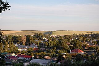
Dmitrovsk is a town and the administrative center of Dmitrovsky District in Oryol Oblast, Russia, located on the Obshcheritsa River near its confluence with the Nerussa, 100 kilometers (62 mi) southwest of Oryol, the administrative center of the oblast. Population: 5,648 (2010 Census); 6,492 (2002 Census); 6,974 (1989 Census).

Bolkhovsky District is an administrative and municipal district (raion), one of the twenty-four in Oryol Oblast, Russia. It is located in the north of the oblast. The area of the district is 1,182.2 square kilometers (456.4 sq mi). Its administrative center is the town of Bolkhov. Population: 18,041 ; 20,417 (2002 Census); 23,921 (1989 Census). The population of Bolkhov accounts for 63.3% of the district's total population.

Dolzhansky District is an administrative and municipal district (raion), one of the twenty-four in Oryol Oblast, Russia. It is located in the southeast of the oblast. The area of the district is 908.4 square kilometers (350.7 sq mi). Its administrative center is the urban locality of Dolgoye. Population: 11,984 ; 14,187 (2002 Census); 15,364 (1989 Census). The population of Dolgoye accounts for 37.1% of the district's total population.

Glazunovsky District is an administrative and municipal district (raion), one of the twenty-four in Oryol Oblast, Russia. It is located in the south of the oblast. The area of the district is 580.9 square kilometers (224.3 sq mi). Its administrative center is the urban locality of Glazunovka. Population: 13,162 ; 14,976 (2002 Census); 16,651 (1989 Census). The population of Glazunovka accounts for 45.1% of the district's total population.

Khotynetsky District is an administrative and municipal district (raion), one of the twenty-four in Oryol Oblast, Russia. It is located in the northwest of the oblast. The area of the district is 800 square kilometers (310 sq mi). Its administrative center is the urban locality of Khotynets. Population: 10,183 ; 12,098 (2002 Census); 13,032 (1989 Census). The population of the administrative center accounts for 38.0% of the district's total population.

Kolpnyansky District is an administrative and municipal district (raion), one of the twenty-four in Oryol Oblast, Russia. It is located in the southeast of the oblast. The area of the district is 1,176.7 square kilometers (454.3 sq mi). Its administrative center is the urban locality of Kolpna. Population: 15,453 ; 18,970 (2002 Census); 22,406 (1989 Census). The population of Kolpna accounts for 42.8% of the district's total population.

Korsakovsky District is an administrative and municipal district (raion), one of the twenty-four in Oryol Oblast, Russia. It is located in the northeast of the oblast. The area of the district is 690.9 square kilometers (266.8 sq mi). Its administrative center is the rural locality of Korsakovo. Population: 4,798 ; 5,586 (2002 Census). The population of Korsakovo accounts for 30.3% of the district's total population.

Krasnozorensky District is an administrative and municipal district (raion), one of the twenty-four in Oryol Oblast, Russia. It is located in the east of the oblast. The area of the district is 650.0 square kilometers (251.0 sq mi). Its administrative center is the rural locality of Krasnaya Zarya. Population: 6,504 ; 8,610 (2002 Census); 9,344 (1989 Census). The population of Krasnaya Zarya accounts for 24.1% of the district's total population.

Kromskoy District is an administrative and municipal district (raion), one of the twenty-four in Oryol Oblast, Russia. It is located in the southwest of the oblast. The area of the district is 969 square kilometers (374 sq mi). Its administrative center is the urban locality of Kromy. Population: 21,346 ; 24,400 (2002 Census); 24,825 (1989 Census). The population of Kromy accounts for 31.5% of the district's total population.

Maloarkhangelsky District is an administrative and municipal district (raion), one of the twenty-four in Oryol Oblast, Russia. It is located in the south of the oblast. The area of the district is 754.3 square kilometers (291.2 sq mi). Its administrative center is the town of Maloarkhangelsk. Population: 11,520 ; 13,798 (2002 Census); 15,558 (1989 Census). The population of Maloarkhangelsk accounts for 31.4% of the district's total population.

Mtsensky District is an administrative and municipal district (raion), one of the twenty-four in Oryol Oblast, Russia. It is located in the north of the oblast. The area of the district is 1,665.8 square kilometers (643.2 sq mi). Its administrative center is the town of Mtsensk. Population: 19,233 ; 20,757 (2002 Census); 22,317 (1989 Census).

Novoderevenkovsky District is an administrative and municipal district (raion), one of the twenty-four in Oryol Oblast, Russia. It is located in the northeast of the oblast. The area of the district is 1,024.9 square kilometers (395.7 sq mi). Its administrative center is the urban locality of Khomutovo. Population: 10,704 ; 13,486 (2002 Census); 14,672 (1989 Census). The population of Khomutovo accounts for 39.5% of the district's total population.

Pokrovsky District is an administrative and municipal district (raion), one of the twenty-four in Oryol Oblast, Russia. It is located in the southeastern central part of the oblast. The area of the district is 1,411 square kilometers (545 sq mi). Its administrative center is the urban locality of Pokrovskoye. Population: 14,782 ; 18,027 (2002 Census); 20,056 (1989 Census). The population of Pokrovskoye accounts for 30.0% of the district's total population.

Shablykinsky District is an administrative and municipal district (raion), one of the twenty-four in Oryol Oblast, Russia. It is located in the west of the oblast. The area of the district is 847.5 square kilometers (327.2 sq mi). Its administrative center is the urban locality of Shablykino. Population: 8,045 ; 9,588 (2002 Census); 10,644 (1989 Census). The population of Shablykino accounts for 42.4% of the district's total population.

Soskovsky District is an administrative and municipal district (raion), one of the twenty-four in Oryol Oblast, Russia. It is located in the west of the oblast. The area of the district is 611.6 square kilometers (236.1 sq mi). Its administrative center is the rural locality of Soskovo. Population: 5,982 ; 8,214 (2002 Census); 9,122 (1989 Census). The population of Soskovo accounts for 30.0% of the district's total population.
Sverdlovsky District is an administrative and municipal district (raion), one of the twenty-four in Oryol Oblast, Russia. It is located in the center of the oblast. The area of the district is 1,061.4 square kilometers (409.8 sq mi). Its administrative center is the urban locality of Zmiyovka. Population: 16,311 ; 18,070 (2002 Census); 19,223 (1989 Census). The population of Zmiyovka accounts for 36.6% of the district's total population.


