Mtsensk

Last updated • 2 min readFrom Wikipedia, The Free Encyclopedia

Mtsensk
Мценск
Mtsensk view on Zusha River and the town crop.jpg
View of Mtsensk
Flag of Mtsensk.svg
Coat of arms of Mtsensk.svg
Location of Mtsensk
Mtsensk
Russia administrative location map.svg
Red pog.svg
Mtsensk
Location of Mtsensk
Outline Map of Orlovskaya Oblast.svg
Red pog.svg
Mtsensk
Mtsensk (Oryol Oblast)
Coordinates: 53°17′N36°34′E / 53.283°N 36.567°E / 53.283; 36.567
Country Russia
Federal subject Oryol Oblast [1]
First mentioned1146
Town status since1778
Elevation
160 m (520 ft)
Population
  Total43,222
  Subordinated to town of oblast significance of Mtsensk [1]
   Capital of Mtsensky District, [1] town of oblast significance of Mtsensk [1]
  Urban okrugMtsensk Urban Okrug [3]
   Capital ofMtsensk Urban Okrug, [3] Mtsensky Municipal District [4]
Time zone UTC+3 (MSK   OOjs UI icon edit-ltr-progressive.svg [5] )
Postal code(s) [6]
303030–303032, 303035, 303036, 303039
Dialing code(s) +7 48646
OKTMO ID54710000001
Website www.adm-mtsensk.ru/index.html

Mtsensk (Russian : Мценск) is a town in Oryol Oblast, Russia, located on the Zusha River (a tributary of the Oka) 49 kilometers (30 mi) northeast of Oryol, the administrative center of the oblast. Population: 43,222(2010 Census); [2] 47,807(2002 Census); [7] 48,400(1989 Soviet census); [8] 28,000 (1970).

Contents

History

Historical affiliations

Principality of Chernigov 1146–1320
Alex K Grundwald flags 1410-03.svg Grand Duchy of Lithuania 1320–1505
Lob flag moskovskiy.svg Grand Duchy of Moscow 1505–1547
Flag of Oryol (variant).svg Tsardom of Russia 1547–1721
Flag of Russia.svg  Russian Empire 1721–1917
Flag of Russia.svg Russian Republic 1917
Flag of Russian SFSR (1918-1937).svg Soviet Russia 1917–1922
Flag of the Soviet Union.svg  Soviet Union 1922–1991
Flag of Russia.svg  Russian Federation 1991–present

It was first mentioned in the Nikon Chronicle in 1146 as a part of the Principality of Chernigov.[ citation needed ] The name comes from the Mtsena River, a tributary of the Zusha, beside which the fortress stood. In 1238, Mtsensk was destroyed by Batu Khan. Since 1320, it was under the rule of Lithuania, eventually becoming a part of the Muscovy in 1505. Since the beginning of the 19th century, Mtsensk was rapidly developing as an industrial town.

During Operation Barbarossa, German armoured forces captured the town in the fall of 1941. In particular, troops of the 3rd Panzer Division, 4th Panzer Division, and Infantry Regiment Großdeutschland saw combat in the immediate vicinity. During the Battle of Kursk in 1943, Mtsensk served as the primary war zone. On 20 July 1943, Mtsensk was liberated by Soviet troops of the Bryansk Front.

Administrative and municipal status

Within the framework of administrative divisions, Mtsensk serves as the administrative center of Mtsensky District, even though it is not a part of it. [1] As an administrative division, it is incorporated separately as the town of oblast significance of Mtsensk—an administrative unit with the status equal to that of the districts. [1] As a municipal division, the town of oblast significance of Mtsensk is incorporated as Mtsensk Urban Okrug. [3]

Twin towns – sister cities

Mtsensk is twinned with: [9]

See also

Related Research Articles

<span class="mw-page-title-main">Livny</span> Town in Oryol Oblast, Russia

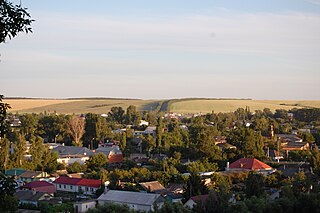
Livny is a town in Oryol Oblast, Russia. As of 2018, it had a population of 47,221.

<span class="mw-page-title-main">Glazunovsky District</span> District in Oryol Oblast, Russia

Glazunovsky District is an administrative and municipal district (raion), one of the twenty-four in Oryol Oblast, Russia. It is located in the south of the oblast. The area of the district is 580.9 square kilometers (224.3 sq mi). Its administrative center is the urban locality of Glazunovka. Population: 13,162 ; 14,976 (2002 Census); 16,651 (1989 Soviet census). The population of Glazunovka accounts for 45.1% of the district's total population.

<span class="mw-page-title-main">Khotynetsky District</span> District in Oryol Oblast, Russia

Khotynetsky District is an administrative and municipal district (raion), one of the twenty-four in Oryol Oblast, Russia.

<span class="mw-page-title-main">Kolpnyansky District</span> District in Oryol Oblast, Russia

Kolpnyansky District is an administrative and municipal district (raion), one of the twenty-four in Oryol Oblast, Russia. It is located in the southeast of the oblast. The area of the district is 1,176.7 square kilometers (454.3 sq mi). Its administrative center is the urban locality of Kolpna. Population: 15,453 ; 18,970 (2002 Census); 22,406 (1989 Soviet census). The population of Kolpna accounts for 42.8% of the district's total population.

<span class="mw-page-title-main">Krasnozorensky District</span> District in Oryol Oblast, Russia

Krasnozorensky District is an administrative and municipal district (raion), one of the twenty-four in Oryol Oblast, Russia. It is located in the east of the oblast. The area of the district is 650.0 square kilometers (251.0 sq mi). Its administrative center is the rural locality of Krasnaya Zarya. Population: 6,504 ; 8,610 (2002 Census); 9,344 (1989 Soviet census). The population of Krasnaya Zarya accounts for 24.1% of the district's total population.

<span class="mw-page-title-main">Kromskoy District</span> District in Oryol Oblast, Russia

Kromskoy District is an administrative and municipal district (raion), one of the twenty-four in Oryol Oblast, Russia. It is located in the southwest of the oblast. The area of the district is 969 square kilometers (374 sq mi). Its administrative center is the urban locality of Kromy. Population: 21,346 ; 24,400 (2002 Census); 24,825 (1989 Soviet census). The population of Kromy accounts for 31.5% of the district's total population.

<span class="mw-page-title-main">Livensky District</span> District in Oryol Oblast, Russia

Livensky District is an administrative and municipal district (raion), one of the twenty-four in Oryol Oblast, Russia. It is located in the southwest of the oblast. The area of the district is 1,806.3 square kilometers (697.4 sq mi). Its administrative center is the town of Livny. Population: 32,791 ; 34,200 (2002 Census); 34,503 (1989 Soviet census).

<span class="mw-page-title-main">Maloarkhangelsky District</span> District in Oryol Oblast, Russia

Maloarkhangelsky District is an administrative and municipal district (raion), one of the twenty-four in Oryol Oblast, Russia. It is located in the south of the oblast. The area of the district is 754.3 square kilometers (291.2 sq mi). Its administrative center is the town of Maloarkhangelsk. Population: 11,520 ; 13,798 (2002 Census); 15,558 (1989 Soviet census). The population of Maloarkhangelsk accounts for 31.4% of the district's total population.

<span class="mw-page-title-main">Mtsensky District</span> District in Oryol Oblast, Russia

Mtsensky District is an administrative and municipal district (raion), one of the twenty-four in Oryol Oblast, Russia. It is located in the north of the oblast. The area of the district is 1,665.8 square kilometers (643.2 sq mi). Its administrative center is the town of Mtsensk. Population: 19,233 ; 20,757 (2002 Census); 22,317 (1989 Soviet census).

<span class="mw-page-title-main">Novosilsky District</span> District in Oryol Oblast, Russia

Novosilsky District is an administrative and municipal district (raion), one of the twenty-four in Oryol Oblast, Russia. It is located in the northeast of the oblast. The area of the district is 778.3 square kilometers (300.5 sq mi). Its administrative center is the town of Novosil. Population: 8,561 ; 10,591 (2002 Census); 16,800 (1989 Soviet census). The population of Novosil accounts for 42.7% of the district's total population.

<span class="mw-page-title-main">Orlovsky District, Oryol Oblast</span> District in Oryol Oblast, Russia

Orlovsky District is an administrative and municipal district (raion), one of the twenty-four in Oryol Oblast, Russia. It is located in the center of the oblast. The area of the district is 1,701.4 square kilometers (656.9 sq mi). Its administrative center is the city of Oryol. Population: 67,384 ; 66,167 (2002 Census); 63,801 (1989 Soviet census).

<span class="mw-page-title-main">Pokrovsky District</span> District in Oryol Oblast, Russia

Pokrovsky District is an administrative and municipal district (raion), one of the twenty-four in Oryol Oblast, Russia. It is located in the southeastern central part of the oblast. The area of the district is 1,411 square kilometers (545 sq mi). Its administrative center is the urban locality of Pokrovskoye. Population: 14,782 ; 18,027 (2002 Census); 20,056 (1989 Soviet census). The population of Pokrovskoye accounts for 30.0% of the district's total population.

<span class="mw-page-title-main">Shablykinsky District</span> District in Oryol Oblast, Russia

Shablykinsky District is an administrative and municipal district (raion), one of the twenty-four in Oryol Oblast, Russia. It is located in the west of the oblast. The area of the district is 847.5 square kilometers (327.2 sq mi). Its administrative center is the urban locality of Shablykino. Population: 8,045 ; 9,588 (2002 Census); 10,644 (1989 Soviet census). The population of Shablykino accounts for 42.4% of the district's total population.

<span class="mw-page-title-main">Soskovsky District</span> District in Oryol Oblast, Russia

Soskovsky District is an administrative and municipal district (raion), one of the twenty-four in Oryol Oblast, Russia. It is located in the west of the oblast. The area of the district is 611.6 square kilometers (236.1 sq mi). Its administrative center is the rural locality of Soskovo. Population: 5,982 ; 8,214 (2002 Census); 9,122 (1989 Soviet census). The population of Soskovo accounts for 30.0% of the district's total population.

<span class="mw-page-title-main">Trosnyansky District</span> District in Oryol Oblast, Russia

Trosnyansky District is an administrative and municipal district (raion), one of the twenty-four in Oryol Oblast, Russia. It is located in the southwest of the oblast. The area of the district is 769.7 square kilometers (297.2 sq mi). Its administrative center is the rural locality of Trosna. Population: 10,302 ; 12,453 (2002 Census); 14,102 (1989 Soviet census). The population of Trosna accounts for 24.6% of the district's total population.

<span class="mw-page-title-main">Uritsky District</span> District in Oryol Oblast, Russia

Uritsky District is an administrative and municipal district (raion), one of the twenty-four in Oryol Oblast, Russia. It is located in the west of the oblast. The area of the district is 838.4 square kilometers (323.7 sq mi). Its administrative center is the urban locality of Naryshkino. Population: 18,666 ; 20,224 (2002 Census); 19,082 (1989 Soviet census). The population of Naryshkino accounts for 51.3% of the district's total population.

<span class="mw-page-title-main">Verkhovsky District</span> District in Oryol Oblast, Russia

Verkhovsky District is an administrative and municipal district (raion), one of the twenty-four in Oryol Oblast, Russia. It is located in the east of the oblast. The area of the district is 1,072.4 square kilometers (414.1 sq mi). Its administrative center is the urban locality of Verkhovye. Population: 17,283 ; 21,384 (2002 Census); 24,888 (1989 Soviet census). The population of Verkhovye accounts for 41.5% of the district's total population.

<span class="mw-page-title-main">Soskovo, Oryol Oblast</span> Rural locality in Oryol Oblast, Russia

Soskovo is a rural locality and the administrative center of Soskovsky District, Oryol Oblast, Russia. Population: 1,794 (2010 Census); 2,122 (2002 Census); 1,759 (1989 Soviet census).

Znamenskoye is a rural locality and the administrative center of Znamensky District, Oryol Oblast, Russia. Population: 1,699 (2010 Census); 1,976 (2002 Census); 1,549 (1989 Soviet census).

<span class="mw-page-title-main">Trosna, Trosnyansky District, Oryol Oblast</span> Rural locality in Oryol Oblast, Russia

Trosna is a rural locality and the administrative center of Trosnyansky District, Oryol Oblast, Russia. Population: 2,530 (2010 Census); 2,662 (2002 Census); 2,346 (1989 Soviet census).

References

Mtsensk railway station Mtsensk Railway Station building.jpg
Mtsensk railway station
St. George Church in Mtsensk Mtsensk StGeorge Church - view from hill.jpg
St. George Church in Mtsensk
memorial to fallen Soviet soldiers Vechnyi ogon' Mtsensk.jpg
memorial to fallen Soviet soldiers

Notes

  1. 1 2 3 4 5 6 7 Law #522-OZ
  2. 1 2 Russian Federal State Statistics Service (2011). Всероссийская перепись населения 2010 года. Том 1 [2010 All-Russian Population Census, vol. 1]. Всероссийская перепись населения 2010 года [2010 All-Russia Population Census] (in Russian). Federal State Statistics Service.
  3. 1 2 3 Law #435-OZ
  4. Law #434-OZ
  5. "Об исчислении времени". Официальный интернет-портал правовой информации (in Russian). June 3, 2011. Retrieved January 19, 2019.
  6. Почта России. Информационно-вычислительный центр ОАСУ РПО. (Russian Post). Поиск объектов почтовой связи (Postal Objects Search) (in Russian)
  7. Federal State Statistics Service (May 21, 2004). Численность населения России, субъектов Российской Федерации в составе федеральных округов, районов, городских поселений, сельских населённых пунктов – районных центров и сельских населённых пунктов с населением 3 тысячи и более человек [Population of Russia, Its Federal Districts, Federal Subjects, Districts, Urban Localities, Rural Localities—Administrative Centers, and Rural Localities with Population of Over 3,000](XLS). Всероссийская перепись населения 2002 года [All-Russia Population Census of 2002] (in Russian).
  8. Всесоюзная перепись населения 1989 г. Численность наличного населения союзных и автономных республик, автономных областей и округов, краёв, областей, районов, городских поселений и сёл-райцентров [All Union Population Census of 1989: Present Population of Union and Autonomous Republics, Autonomous Oblasts and Okrugs, Krais, Oblasts, Districts, Urban Settlements, and Villages Serving as District Administrative Centers]. Всесоюзная перепись населения 1989 года [All-Union Population Census of 1989] (in Russian). Институт демографии Национального исследовательского университета: Высшая школа экономики [Institute of Demography at the National Research University: Higher School of Economics]. 1989 via Demoscope Weekly.
  9. "Города-побратимы города Мценска". adm-mtsensk.ru (in Russian). Mtsensk. Retrieved February 6, 2020.

Sources