Otorohanga District

Last updated
Otorohanga District
Otorohanga District.svg
Country New Zealand
Region Waikato
District Otorohanga District Council
Wards Kawhia-Tihiroa
Waipa
Wharepuhunga
Kiokio-Korakonui
Otorohanga
Formed1979
Seat Otorohanga
Government
  MayorMax Baxter
  Deputy MayorDeborah Pilkington
Area
  Total1,976 km2 (763 sq mi)
Population
 (June 2018) [1]
  Total10,250
  Density5.2/km2 (13/sq mi)
Time zone UTC+12 (NZST)
  Summer (DST) UTC+13 (NZDT)
Postcode(s)
Website Otorohanga District

Otorohanga District is a territorial municipality in the King Country region of the North Island of New Zealand. It is a mostly rural area, with Otorohanga town being by far the biggest urban area, with a population nearing 3,000. The District was called Otorohanga County from 1971 to 1979.

Territorial authorities of New Zealand councils for local administration in New Zealand

Territorial authorities are the second tier of local government in New Zealand, below regional councils. There are 67 territorial authorities: 13 city councils, 53 district councils and the Chatham Islands Council. District councils serve a combination of rural and urban communities, while city councils administer the larger urban areas. Five territorial authorities also perform the functions of a regional council and thus are unitary authorities. The Chatham Islands Council is a sui generis territorial authority that is similar to a unitary authority.

The King Country is a region of the western North Island of New Zealand. It extends approximately from the Kawhia Harbour and the town of Otorohanga in the north to the upper reaches of the Whanganui River in the south, and from the Hauhungaroa and Rangitoto Ranges in the east to near the Tasman Sea in the west. It comprises hill country, large parts of which are forested.

Otorohanga Place in Waikato, New Zealand

Otorohanga is a north King Country town in the Waikato region in the North Island of New Zealand. It is located 53 kilometres (33 mi) south of Hamilton and 18 kilometres (11 mi) north of Te Kuiti, on the Waipa River. It is a service town for the surrounding dairy-farming district. It is recognised as the "gateway" to the Waitomo Caves and as the "Kiwiana Town" of New Zealand. Until 2007, Otorohanga held a yearly 'Kiwiana Festival.'

Contents

Geography and population

Otorohanga District is located south of Hamilton, west of Rotorua, and northwest of Taupo. It stretches from Kawhia Harbour on the west coast inland to the Pureora Forest Park. Adjacent local government districts are (clockwise from the north) Waikato, Waipa, South Waikato, Taupo, and Waitomo. The district has a land area of 1,976 square kilometres (763 sq mi). [2] It is a mostly rural area, with significant areas of native forest.

Hamilton, New Zealand City in North Island, New Zealand

Hamilton is a city in the North Island of New Zealand. It is the seat and most populous city of the Waikato region, with a territorial population of 169,300, the country's fourth most-populous city. Encompassing a land area of about 110 km2 (42 sq mi) on the banks of the Waikato River, Hamilton is part of the wider Hamilton Urban Area, which also encompasses the nearby towns of Ngaruawahia, Te Awamutu and Cambridge.

Rotorua City in Bay of Plenty, New Zealand

Rotorua is a city on the southern shores of Lake Rotorua from which the city takes its name, located in the Bay of Plenty Region of New Zealand's North Island. It is the seat of the Rotorua District, a territorial authority encompassing Rotorua and several other nearby towns. The majority of the Rotorua District is in the Bay of Plenty Region, but a sizeable southern section and a small western section are in the Waikato Region. Rotorua is in the heart of the North Island, 60 kilometres south of Tauranga, 80 km (50 mi) north of Taupo, 105 km (65 mi) east of Hamilton, and 230 km (140 mi) southeast of the nation's most populous city, Auckland.

Taupo Secondary urban area in North Island, New Zealand

Taupō is a town on the shore of Lake Taupō, which occupies the caldera of the Taupō Volcano in the centre of the North Island of New Zealand. It is the seat of the Taupō District Council and lies in the southern Waikato Region.

The district's population at June 2018 was 10,250. [1] The town of Otorohanga, located at about the centre of the district, is the largest town, with a population nearing 3,000. Other communities include Hauturu, Honikiwi, Kawhia, Maihiihi, Oparau, Otewa, Owhiro, Puketotara, Te Kawa and Wharepuhunga. [3]

Hauturu is a village near the eastern shores of the Kawhia Harbour, in the Otorohanga District and Waikato Region of New Zealand's North Island.

Maihiihi is a rural community in the Otorohanga District and Waikato Region of New Zealand's North Island.

Otewa is a rural community in the Otorohanga District and Waikato Region of New Zealand's North Island.

History

After the land wars, the wider area of the King Country was a refuge for Tāwhiao, the second Māori King, and his followers. From 1864 to 1883, pākehā (white settlers) were not allowed into the area unless they had express permission. The district was used for farming from the late 19th century onwards.

New Zealand Wars 1845–1872 armed conflicts in New Zealand

The New Zealand Wars were a series of armed conflicts that took place in New Zealand from 1845 to 1872 between the Colonial government and allied Māori on one side and Māori and Māori-allied settlers on the other. They were previously commonly referred to as the Land Wars or the Māori Wars while Māori language names for the conflicts included Ngā pakanga o Aotearoa and Te riri Pākehā. Historian James Belich popularised the name "New Zealand Wars" in the 1980s, although the term was first used by historian James Cowan in the 1920s.

Tāwhiao Maori king

Tāwhiao was leader of the Waikato tribes, the second Māori King and a religious visionary. He was a member of the Ngāti Mahuta iwi (tribe) of Waikato.

Māori King Movement Movement that arose among some of the Māori tribes of New Zealand in the central North Island in the 1850s.

The Māori King Movement or Kīngitanga is a movement that arose among some of the Māori tribes of New Zealand in the central North Island in the 1850s, to establish a role similar in status to that of the monarch of the British colonists, as a way of halting the alienation of Māori land. The Māori monarch operates in a non-constitutional capacity with no legal or judicial power within the New Zealand government. Reigning monarchs retain the position of paramount chief of several tribes (iwi) and wield some power over these, especially within Tainui where the monarchy is almost exclusively associated.

The first municipal government, Otorohanga County, was formed in 1922. In 1956, the northern part of Kawhia County and Otorohanga County were amalgamated. On 1 November 1971, Otorohanga Borough was subsumed into Otorohanga County. The Otorohanga District was declared in 1979 by renaming Otorohanga County. [2] It was reconstituted as part of the 1989 local government reforms, with a nearly identical area. [4]

1989 local government reforms

The 1989 local government reform was the most significant reform of local government in New Zealand in over a century. Some 850 local bodies were amalgamated into 86 local authorities, made up of regional and territorial levels.

Governance

The seat of Otorohanga District Council is in the town of Otorohanga. The council is headed by a mayor, and complemented by seven councillors from five wards. The council wards are Kawhia/Tihiroa (two councillors), Waipa, Wharepuhunga, Kiokio/ Korakonui, and Otorohanga (two councillors). [5] Max Baxter has been the mayor since the 2013 local elections. [6]

The 2013 New Zealand local elections were triennial elections to elect local government officials and District Health Board members, and the membership of other local bodies such as Licensing Trusts. All elections were conducted by postal ballot, with election day being Saturday 12 October 2013.

The District is entirely within the wider Waikato Regional Council area. [4]

Related Research Articles

Waikato region in New Zealands North Island

Waikato is a local government region of the upper North Island of New Zealand. It covers the Waikato District, Hauraki, Coromandel Peninsula, the northern King Country, much of the Taupo District, and parts of Rotorua District. It is governed by the Waikato Regional Council.

Cambridge, New Zealand Town in Waikato, New Zealand

Cambridge is a town in the Waipa District of the Waikato Region of the North Island of New Zealand. Situated 24 kilometres (15 mi) southeast of Hamilton, on the banks of the Waikato River, Cambridge is known as "The Town of Trees & Champions". The town has a population of 19,150, making it the largest town in the Waipa District, and third largest urban area in the Waikato.

Rodney District Former local government area in New Zealand

Rodney District was a local government area in the northernmost part of New Zealand's Auckland Region from 1989 to 2010. It included Kawau Island. It was created from the amalgamation of Helensville Borough and Rodney County in 1989. The seat of Rodney District Council was at Orewa. Rodney District and Rodney County each took their names from Cape Rodney, which Captain James Cook named on 24 November 1769 after Admiral Sir George Brydges Rodney.

Franklin District Former territorial authority in New Zealand

Franklin District was a New Zealand territorial authority that lay between the Auckland metropolitan area and the Waikato Plains. As a formal territory it was abolished on 31 October 2010 and divided between Auckland Council in the Auckland Region to the north and Waikato and Hauraki districts in the Waikato Region to the south and east. The Auckland portion is now part of the Franklin ward, which also includes rural parts of the former Manukau City.

Te Awamutu Town

Te Awamutu is a town in the Waikato region in the North Island of New Zealand. It is the council seat of the Waipa District and serves as a service town for the farming communities which surround it. Te Awamutu is located some 30 kilometres (19 mi) south of Hamilton on State Highway 3, one of the two main routes south from Auckland and Hamilton.

Waipa River river in New Zealand

The Waipa River is in the Waikato region of the North Island of New Zealand. The headwaters are in the Rangitoto Range east of Te Kuiti. It flows north for 115 kilometres (71 mi), passing through Otorohanga and Pirongia, before flowing into the Waikato River at Ngaruawahia. It is the Waikato's largest tributary. The Waipa's main tributary is the Puniu River.

Waikato District Territorial authority in Waikato, New Zealand

Waikato District is a territorial authority of New Zealand, in the northern part of Waikato Region, North Island. Waikato District is administered by the Waikato District Council, with headquarters in Ngaruawahia.

Waipa District Place in Waikato, New Zealand

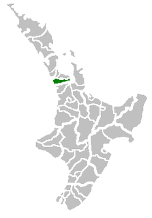
Waipa District is a municipality in the Waikato region of New Zealand that is administered by the Waipa District Council. Its most populous town is Cambridge. The seat of the council is at the second most populous town, Te Awamutu. The district is south and south-east of the city of Hamilton. It has five wards: Te Awamutu, Cambridge, Pirongia, Maungatautari and Kakepuku.

South Waikato District Territorial authority in Waikato, New Zealand

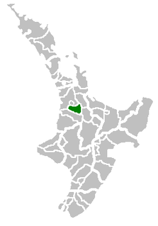
South Waikato District is a local government district in the Waikato Region of the North Island of New Zealand. It is located between the cities of Hamilton to the north, Rotorua to the east, Taupo to the south and Ruapehu District to the west.

Waitomo District Territorial authority in Waikato Region, New Zealand

Waitomo District is a territorial authority, located in the Waikato region, at the north of the King Country area in the North Island of New Zealand. A small part of the district, the town of Tiroa, however, lies in the Manawatu-Wanganui region.

Ruapehu District Territorial authority of New Zealand in North Island

Ruapehu District is a territorial authority in the centre of New Zealand's North Island.

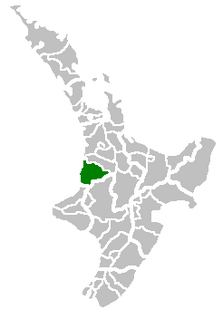
The Taupo District Council is a territorial authority that administers the Taupo District in the Central North Island of New Zealand. The district stretches from the small town of Mangakino in the northwest to the Tongariro National Park in the south, and east into the Kaingaroa Forest, covering 6,970 km2. It had a population of 37,200 as of the June 2018.

Taupo District District in New Zealand

The Taupo District is a district in New Zealand. It covers 6,350 km² of land, as well as a further 610 km² of lake area, both in Lake Taupo, New Zealand's largest lake, and also in the smaller Lake Rotoaira. The district stretches from the small town of Mangakino in the northwest to the Tongariro National Park in the south, and east into the Kaingaroa Forest. The district's population is largely located in the two main centres, Taupo and Turangi.

The Waikato and King Country regions of New Zealand are built upon a basement of greywacke rocks, which form many of the hills. Much of the land to the west of the Waikato River and in the King Country to the south has been covered by limestone and sandstone, forming bluffs and a karst landscape. The volcanic cones of Karioi and Pirongia dominate the landscape near Raglan and Kawhia Harbours. To the east, the land has been covered with ignimbrite deposits from the Taupo Volcanic Zone. Large amounts of pumice from the Taupo Volcanic Zone have been deposited in the Waikato Basin and Hauraki Plains.

Districts of New Zealand district administered by a territorial authority in New Zealand

A district in New Zealand is a territorial authority area governed by a district council as a second-tier of local government in New Zealand, below regional councils. They were formed as a result of local government reforms in 1989. There are 53 districts in New Zealand, and they do not include the 13 city councils, and the Chatham Islands Council. District councils serve a combination of rural and urban communities, while city councils administer the larger urban areas. Three districts are unitary authorities also performing the functions of a regional council.

Gore District, New Zealand Territorial authority in Southland, New Zealand

Gore District is a municipality in the Southland region of the South Island of New Zealand.

State Highway 39 (SH 39) is a New Zealand state highway that forms a western bypass of the city of Hamilton. Gazetted in 1999, it is a generally quicker route to get between Auckland and New Plymouth as well as connecting to the Waitomo Caves, just south of the SH 39 southern terminus. The southernmost 14 km section has a concurrency with SH 31, as this highway has existed for much longer.

John William Ellis

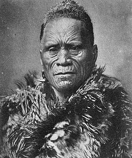
John William Ellis was a New Zealand businessman and mayor of Hamilton from 1917 to 1918.

References

  1. 1 2 "Subnational Population Estimates: At 30 June 2018 (provisional)". Statistics New Zealand. 23 October 2018. Retrieved 23 October 2018. For urban areas, "Subnational population estimates (UA, AU), by age and sex, at 30 June 1996, 2001, 2006-18 (2017 boundaries)". Statistics New Zealand. 23 October 2018. Retrieved 23 October 2018.
  2. 1 2 "About us". Otorohanga District Council. Retrieved 21 July 2019.
  3. Quickstats about Otorohanga District
  4. 1 2 "Proposal for Ōtorohanga District". New Zealand Geographic Board. 27 September 2018. Retrieved 21 July 2019.
  5. "Otorohanga District Council Elected Members". Otorohanga District Council. Archived from the original on 9 June 2016. Retrieved 4 July 2015.
  6. Leaman, Aaron (14 October 2013). "Business as usual as Baxter takes charge". Waikato Times . Retrieved 4 July 2015.