Oued Fes

Last updated • 12 min readFrom Wikipedia, The Free Encyclopedia
The Oued Bou Khrareb (a part of the Oued Fes) flowing through the middle of Fes el-Bali, seen in 2020 Canal Medina Fez Morocco 100817 (49684330503).jpg
The Oued Bou Khrareb (a part of the Oued Fes) flowing through the middle of Fes el-Bali, seen in 2020

The Oued Fes (Arabic : واد فاس, lit. 'River of Fes') or Fez River is a river in Morocco. It is a tributary of the Sebou River and historically the main source of water for Morocco's second largest city, Fes, after which it is named.

Contents

The river consists of a number of different streams which originate in the Saïss Plain to the south and west of Fes before joining together in the area of Fes el-Bali, the old city (medina) of Fes. [1] [2] Over the centuries the river has been split and diverted into a multitude of canals that distributed water across the city and once powered a number of historic waterwheels. [1] [3] These various water channels converge into the Oued Bou Khrareb which runs through the middle of the old city and historically divided the Qarawiyyin and Andalusiyyin quarters. [1] After the river leaves the city it runs eastwards for a short distance before joining the Sebou River. The various branches and sections of the river, including many of the man-made canals, also have their own names.

Description of the river

Source

The river begins at Ras al-Ma ("Head of the Water"), 12 kilometres southwest of the city, from a hollow of lacustrine limestone, with an approximate flow of 500 litres/second. [4] :131

Oued al-Jawahir

The main branch of the river skirts the northern edge of the Royal Palace grounds (the Dar al-Makhzen) and of Fes el-Jdid before entering Fes el-Bali. This section is also known as the Oued al-Jawahir (Arabic : واد الجواهر, lit. 'River of Pearls'). [1] It once passed through a flat area of marshes and wetlands located near what is now Fes el-Jdid and the modern Ville Nouvelle, before emerging at a number places. [5] However, since the founding of Fes el-Jdid (13th century), the Oued al-Jawahir was progressively diverted and some of its old streams seem to have disappeared. [5] The river's flow was re-engineered to provide water for the Royal Palace complex and a succession of royal gardens such as the Mosara Gardens of the Marinids (now disappeared) and the 19th-century Jnan Sbil Gardens (still extant), before continuing towards Fes el-Bali, where it is distributed across an extensive network of man-made streams and canals which end up at the Oued Bou Khrareb. [2] [1]

Oued Bou Khrareb

ETH-BIB-Fluss in Fes-Nordafrikaflug 1932-LBS MH02-13-0369.tif
The Oued Bou Khrareb in a photograph from 1932
Fes insolite.jpg
Oued Bou Khrareb in 2020

Oued Bou Khrareb (or sometimes Oued el-Kbir) is the usual name given to the main urban course of the river through the middle of Fes el-Bali. [1] :122 This river is initially fed by two other streams called the Oued ez-Zitoun and the Oued Bou Fekran that enter the city from the south at Bab Jdid. [1] :234 It is also fed by the various canals that split off from the Oued al-Jawahir to supply the city before eventually ending up in this ravine in the middle of the city. As the lowest point in the medina, the river thus acts as a collector for the city's used water. [4] [3]

The course of the Bou Khrareb also forms the historical boundary between the Qarawiyyin and Andalus quarters of the city, which were originally two separate cities (al-'Aliya and Madinat Fas) in their early history before being joined together by the Almoravids in the 11th century. [1] Much of the Oued Bou Khrareb's course, from Bab Jdid to Place R'cif, is now hidden beneath a modern road for car traffic (one of the few that penetrates the medina). The road covers the river up to Place R'cif, a large square at the heart of the medina, and the river reemerges on the north side of square. [2] [1] From there the river runs northeast and exits the city between Bab Guissa and the former gate of Bab Sidi Bou Jida. [1]

The historic water network of Fez

View of the Oued al-Jawahir's riverbed emerging from under the walls of the Old Mechouar (through the four arches on the right) in Fes el-Jdid. The first major divisions of the river (two canals visible in the foreground on the left) take place here and in the nearby Jnan Sbil Gardens. Oued Fes east of old mechouar DSCF5004.jpg
View of the Oued al-Jawahir's riverbed emerging from under the walls of the Old Mechouar (through the four arches on the right) in Fes el-Jdid. The first major divisions of the river (two canals visible in the foreground on the left) take place here and in the nearby Jnan Sbil Gardens.

Fes el-Bali has had access to plentiful water since its foundation. [1] The current outlines of its water supply system were begun by the Zenata emir Dunas ibn Hamama between 1037 and 1049 and then further elaborated by the Almoravid emir Yusuf ibn Tashfin between 1069 (the Almoravid conquest of Fes) and 1106. [4] [3]

From the west, the Oued al-Jawahir flows eastward along the northern edge of Fes el-Jdid, passing through the Bab Bou Jat Mechouar, through the Dar al-Makina (a former arms factory), and then beneath the Old Mechouar near Bab Dekkakin before re-emerging on its eastern side, on the edge of the Jnan Sbil Gardens. Here it emerges from four arched openings at the bottom of the Old Mechouar's ramparts and the first major man-made division of the river take place. [4] This division creates a number of canals (most of them subterranean) through Fes el-Bali which eventually spill back into the Oued Bou Khrareb (the name of the river's main course inside the city). [4] [1] There are four main historic canal divisions: the Oued Fejjalin, the Oued el-Hamiya, the Sakiyyat el-Abbasa, and the Oued Shrashar. [1] Most of these then split off into other canals as they progress through the city. Within each network, water channels that supplied water for drinking and washing were kept separate from those that were used to evacuate waste. [6]

The Oued Fejjalin is one of the most important divisions. It passes through the north part of the Jnan Sbil Gardens and through the Dar al-Beida Palace, before splitting into more branches. One branch goes south but has mostly disappeared today. The other, the Oued el-Lemtiyyin, continues northeastwards toward the Bou Jeloud area and supplied the northern parts of the city. [4] [1] Just after it enters the city walls, the water of the Oued el-Lemtiyyin is collected by a large distributor structure located adjacent to the south side of Bab Bou Jeloud gate. [7] [6] The structure is made of brick and rammed earth. It originally dates from the Almoravid period, [3] although the wall on its west side is part of the Almohad city walls and some hydraulic features likely underwent modifications over the years as the city developed or the agreements regulating water distribution changed. [7] It has three arched openings that lead into vaulted chambers under the wall from which the water then emerges on the other side into three open-air channels or "zones", located at different elevations. The middle zone consists of a large reservoir that feeds water into three underground canals on its eastern side. The two other zones, located on higher ground on either side of this, received lesser amounts of water but were more complex, consisting of multiple small basins and channels that regulated the distribution into local neighbourhoods. The differences in the depth and elevation of the different reservoirs and channels reflected the institutionalized water agreements under which certain neighbourhoods or buildings had priority access to water, while other sites, with less priority, only received it when the water level was high enough to reach the channels and reservoirs located at higher elevations. The water entering into the distributor was also slowed and diverted by small dams and settling basins, as well as by the various reservoirs themselves, which thus also served as a rudimentary water treatment system by catching and filtering garbage and other physical pollution. From this distributor, the water then spread through various underground canals across the neighbourhoods located downstream, starting with those in the Tala'a Kebira and Tala'a Seghira areas. One of the canals still passes through courtyard of the Bou Inania Madrasa today. Other distributor structures, of smaller size and complexity, were located throughout this network and other networks in order to further regulate water distribution. [7] [4]

As for the Oued el-Hamiya, it splits from the other major branches at Jnan Sbil before dividing into more branches which mostly supply the southern parts of the city. [4] One of its branches also once supplied, via an aqueduct, the Andalus quarter on the opposite shore of the Bou Khrareb river. [1] The two last branches, Sakiyyat al-Abbasa and the Oued Shrashar, supplied the regions near Bab al-Hadid and the gardens between Fes el-Jdid and Fes el-Bali. [1]

In addition to this western network of canals coming from the Oued al-Jawahir, the streams to the south of the city (which also formed the beginning of the Bou Khrareb River) fed an entirely separate but important canal called the Oued Masmuda. [1] This canal, further east, supplied water for most of the Andalus quarter of Fes on the southeast side of the Bou Khrareb river. [1] [4] It begins to the south of the city and passed through the old city walls through a culvert opening called Bab ash-Shobbak ("Gate of the Window") which was protected by an iron grille. [4] [1] A few other canals split from it as it wound its way through the district, until it finally rejoined the Bou Khrareb river shortly before its exit from the city. [1] [4] The canal appears to be named after the Masmuda Berber tribal confederacy that founded the Almohad movement, which suggests that it might have been constructed by the Almohads or that Masmuda families or troops were housed near it at some point. [1] :113

A historic noria (waterwheel) located on the western edge of the Jnan Sbil Gardens between Fes el-Jdid and Fes el-Bali. Noria in fes DSCF2893.jpg
A historic noria (waterwheel) located on the western edge of the Jnan Sbil Gardens between Fes el-Jdid and Fes el-Bali.

Many of these historic canals are now underground, with only some ancient toponyms hinting at former bridges that passed over them (e.g. the name Qantrat Bou Rous along a part of Tala'a Kebira). [1] These canals and streams also feed a number of industries such as the historic tanneries of the city, the most famous of which are the Chouara Tanneries. [1] A large number of waterwheels (known as noria s or sometimes as saqiyyas) were located throughout the city's water network in order to assist in water distribution or to power certain industries. [1] [4] Some of these were very large, such as the huge noria which supplied the Marinid royal gardens of Mosara, measuring 26 meters in diameter and 2 meters in thickness. [2] Only a few of these waterwheels have survived in some form, including some examples around the Jnan Sbil Gardens. [1] [3]

Historic bridges

The Bin el-Mudun Bridge in a 1916 photo Pont - Pont sur l'oued Fes - Fes - Mediatheque de l'architecture et du patrimoine - AP62T089238.jpg
The Bin el-Mudun Bridge in a 1916 photo

The Oued Bou Khrareb is crossed by several historic bridges inside the medina, some of which were first built before the unification of the two shores into a single city in the 11th century. [8] There were once at least six bridges, reportedly built by the Maghrawa ruler Dunas ibn Hamama in the early 11th century, before the unification of the two cities by the Almoravids later in the same century. [9] [1] :51 [8] They have since been repaired or rebuilt many times. [9] The 14th century historian Al-Jazna'i reported that the Almoravid ruler Yusuf Ibn Tashfin (d. 1106) built six bridges, which were named Abu Tuba, Abu Barquqa, Bab al-Silsila, Sebbaghin, Kahf al-Waqqadin, and er-Remila. [3] Many of them were destroyed in the floods of 725 AH (1324 or 1325 CE) and some were subsequently rebuilt by the Marinid sultan at the time, Abu Sa'id (d. 1331). [9] Some bridges have disappeared but their names have endured as local toponyms. [9] A study by María Marcos Cobaleda and Dolores Villalba Sola states that two of the Almoravid bridges are still preserved. [3] Historian Roger Le Tourneau estimated that the three main bridges today date back to the Almohad period at least. [1] :148

The Terrafin Bridge ("Bridge of the Cobblers") over the river in 1932. Today the bridge is located at the northern edge of Place R'cif. ETH-BIB-Brucke in Fes-Nordafrikaflug 1932-LBS MH02-13-0385.tif
The Terrafin Bridge ("Bridge of the Cobblers") over the river in 1932. Today the bridge is located at the northern edge of Place R'cif.

Of the bridges that remain today, the Qantrat Bin el-Mudun ("Bridge Between the Two Cities") is the northernmost of them, followed to the south by the Qantrat Sebbaghin ("Bridge of the Tanners"; also known as the Bridge of Gzam Ben Zakkoun) and by the Qantrat Terrafin ("Bridge of the Cobblers") just north of Place R'cif. [1] :128,142–145Another bridge, the Qantrat Sidi al-'Awwad ("Bridge of Sidi al-'Awwad"), was once located further south, in an area where the river is now covered by a paved road. [1] :142–146 Traditionally, the three most important bridges were those of Bin el-Mudun, Terrafin, and Sidi al-'Awwad, each of which were located along a major thoroughfare of the Andalus quarter (the eastern shore). [1] :142

The Bin el-Mudun Bridge, believed to date from the time of Dunas ibn Hamama, was considered one of the most picturesque, being located amidst a stretch of rocky rapids. [9] María Marcos Cobaleda and Dolores Villalba Sola attribute it to the Almoravid period. [3] It has a span composed of three arches but only the central one is still visible today. [3] The Sebbaghin Bridge, also known as the Khrashfiyin Bridge (or Khrachfiyine in French transliteration), is believed to have been originally built by Dunas ibn Hamama and restored or rebuilt by the Marinids in the 14th century. [8] [9] The Terrafin or al-Tarrafin bridge, [8] [3] originally named Qantrat Bab al-Silsila, [3] is found on the northern edge of Place R'cif. It is also believed to date initially from Emir Dunas in the 11th century, [8] [9] while María Marcos Cobaleda and Dolores Villalba Sola attribute it to the Almoravid period as well. [3] It is the only bridge in Fes to be lined with shops on both sides, similar to many medieval European bridges. [3] [1] :336

Pollution problems and rehabilitation efforts

Traditional tanners are seen working along the Oued Bou Khrareb (2006; before recent renovations to the area). Fes, Old city.jpg
Traditional tanners are seen working along the Oued Bou Khrareb (2006; before recent renovations to the area).

The river, particularly the Oued Bou Khrareb within the old medina, has long suffered from heavy pollution due to sewage, the activities of the nearby tanneries (which generate chemical waste), and to being sometimes used as a dumping ground by residents. [10] [11] Even the name Oued Bou Khrareb means "River of Filth". [1] [10] The increase in pollution in modern times led to locals building walls and concrete barriers to block out the smell of the river, and more recently the city authorities had begun covering the exposed parts of the river with concrete slabs, which only led to more garbage piling up on top of this. [11] [12] The waste of the tanning industry and other activities also led to toxic chemicals, particularly high levels of Chromium, accumulating in the soil and the water. [12] Although it is believed that this does not affect the city's drinking water (which comes from upstream), it creates problems for sites downstream along the Sebou River following its confluence with the Oued Fes. [13] [14]

The Sebbaghin Bridge undergoing restoration in November 2014 Fes bridge restoration 1.jpg
The Sebbaghin Bridge undergoing restoration in November 2014

In the late 2000s, a large-scale project to rehabilitate the river system and its urban environment was begun. The project, led by architect Aziza Chaouni, included the cleaning up of the river, the renovation of its urban shoreline, the creation of open pedestrian walkways, and the renovation of existing open spaces along the river such as Place R'cif and Place Lalla Yeddouna. [10] [11] [15] The proposal to improve water quality also included the creation of wetlands (which had previously existed along the river's course) and the restoration of the river's canals. [11] At one point the project had also proposed to end or curtail the operations of the Chouara Tanneries and relocate the tanning industry elsewhere where its pollution could be managed more safely, [16] [17] but in the end the tanneries were restored and left in place. [18]

The rehabilitation of the river, which has been underway since, also took place alongside broader efforts to restore the historical monuments and landmarks of the old city, mostly under the direction of the local heritage restoration agency ADER-Fes. This included the restoration of the bridges over the Bou Khrareb river, with the Terrafin and Sebbaghin/Khrashfiyin bridges being restored in the 2010s. [8]

Related Research Articles

<span class="mw-page-title-main">Moroccan architecture</span>

Moroccan architecture reflects Morocco's diverse geography and long history, marked by successive waves of settlers through both migration and military conquest. This architectural heritage includes ancient Roman sites, historic Islamic architecture, local vernacular architecture, 20th-century French colonial architecture, and modern architecture.

<span class="mw-page-title-main">Fes el Bali</span> UNESCO World Heritage Site in Fez, Morocco

Fes el Bali is the oldest walled part of Fez, the second largest city of Morocco. Fes el Bali was founded as the capital of the Idrisid dynasty between 789 and 808 AD. UNESCO listed Fes el Bali, along with Fes Jdid, as a World Heritage Site in 1981 under the name Medina of Fez. The World Heritage Site includes Fes el Bali's urban fabric and walls as well as a buffer zone outside of the walls that is intended to preserve the visual integrity of the location. Fes el Bali is, along with Fes Jdid and the French-created Ville Nouvelle or “New Town”, one of the three main districts in Fez.

<span class="mw-page-title-main">Fes Jdid</span> UNESCO World Heritage Site in Fez, Morocco

Fes Jdid or Fes el-Jdid is one of the three parts of Fez, the second largest city of Morocco. It was founded by the Marinids in 1276 as an extension of Fes el Bali and as a royal citadel and capital. It is occupied in large part by the historic Royal Palace, which was once the center of government in Morocco and which is still used on occasion by the King of Morocco today. The district also contains the historic Mellah of the city. Since 1981 it has been classified, along with Fes el-Bali, as a UNESCO World Heritage Site.

<span class="mw-page-title-main">Fez, Morocco</span> City in Fez-Meknes, Morocco

Fes or Fez is a city in northern inland Morocco and the capital of the Fez-Meknes administrative region. It is one of the largest cities in Morocco, with a population of 1.256 million, according to the 2024 census. Located to the northwest of the Atlas Mountains, it is surrounded by hills and the old city is centered around the Fez River flowing from west to east. Fez has been called the "Mecca of the West" and the "Athens of Africa". It is also considered the spiritual and cultural capital of Morocco.

<span class="mw-page-title-main">Bab Bou Jeloud</span> City gate in Fez, Morocco

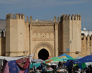
Bab Bou Jeloud is an ornate city gate in Fes el Bali, the old city of Fez, Morocco. The current gate was built by the French colonial administration in 1913 to serve as the grand entrance to the old city.

<span class="mw-page-title-main">Kasbah An-Nouar</span>

The Kasbah An-Nouar or Kasbah Filali is a walled district and former military enclosure in the old medina of Fez, Morocco. Its name means "citadel of the flowers", but it is sometimes also referred to as Kasbah Filala and Kasbah Chorfa. It is one of several fortified military enclosures or kasbahs that were built around the old city of Fez across different periods.

<span class="mw-page-title-main">Chouara Tannery</span> Moroccan tannery in Fez

Chouara Tannery is one of the three tanneries in the city of Fez, Morocco. It is the largest tannery in the city and one of the oldest. It is located in Fes el Bali, the oldest medina quarter of the city, near the Saffarin Madrasa along the Oued Fes. Since the inception of the city, the tanning industry has been continually operating in the same fashion as it did in the early centuries. Today, the tanning industry in the city is considered one of the main tourist attractions. The tanneries are packed with round stone vessels filled with dye or white liquids for softening the hides. The leather goods produced in the tanneries are exported around the world.

<span class="mw-page-title-main">Dar Batha</span> Palace, riad in Fes, Morocco

Dar Batḥa, or Qasr al-Batḥa, is a former royal palace in the city of Fez, Morocco. The palace was commissioned by the Alaouite Sultan Hassan I in the late 19th century and finished under his successor Abdelaziz. It was converted into a museum of historical arts and crafts in 1915 with a collection that now comprises over 6,500 objects. The palace is located near Bab Bou Jeloud at the western edge of Fes el-Bali, the old medina quarter of the city, and close to Fes el-Jdid, the new medina quarter. It is adjacent to the Dar el-Beida palace located to its southeast, which was originally part of the same complex.

<span class="mw-page-title-main">Royal Palace of Fez</span> Palace complex in Fes, Morocco

The Royal Palace or Dar al-Makhzen is the palace of the King of Morocco in the city of Fez, Morocco. Its original foundation dates back to the foundation of Fes el-Jdid, the royal citadel of the Marinid dynasty, in 1276 CE. Most of the palace today dates from the 'Alawi era. The vast grounds are home to multiple private structures, patios, and gardens, but historically also included administrative offices and government tribunals. Today, the most publicly visible parts of the palace are its main entrances at the Old Mechouar and the highly ornate 20th-century gates at Place des Alaouites, near the Mellah.

<span class="mw-page-title-main">R'cif Mosque</span> Mosque in Fez, Morocco

The R'cif Mosque is a Friday mosque in Fes el-Bali, the old city (medina) of Fez, Morocco. It has one of the tallest minarets in the city and overlooks Place R'cif in the heart of the medina.

<span class="mw-page-title-main">Fortifications of Fez</span> Defensive structures of the old city of Fez, Morocco

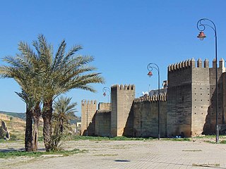
The Fortifications of Fez comprise a complex circuit of ramparts and gates surrounding Fes el-Bali and Fes el-Jdid, two urban agglomerations that compose the old "medina" of Fes, Morocco. They also include a number of kasbahs (citadels) and forts which were built both to protect and to control the city. These fortifications have been built up over many centuries and the extensive remnants today date from many different periods.

<span class="mw-page-title-main">Architecture of Fez</span>

The architecture of Fez, Morocco, reflects the wider trends of Moroccan architecture dating from the city's foundation in the late 8th century and up to modern times. The old city (medina) of Fes, consisting of Fes el-Bali and Fes el-Jdid, is notable for being an exceptionally well-preserved medieval North African city and is classified as a UNESCO World Heritage Site. A large number of historic monuments from different periods still exist in it today, including mosques, madrasas, synagogues, hammams (bathhouses), souqs (markets), funduqs (caravanserais), defensive walls, city gates, historic houses, and palaces.

<span class="mw-page-title-main">Bab Guissa</span> City gate in Fes, Morocco

Bab Guissa or Bab Gisa is the main northwestern gate of Fes el Bali, the old walled city of Fes, Morocco.

<span class="mw-page-title-main">Jnan Sbil Gardens</span> Public Garden

The Jnan Sbil Gardens, also known as the Bou Jeloud Gardens, is public garden in Fez, Morocco, located between Fes el-Jdid and Fes el-Bali, the two sections of the old medina.

<span class="mw-page-title-main">Bab Dekkakin</span> City gate in Morocco

Bab Dekkakin or Bab Dekakene is a fortified and ceremonial gate in Fes, Morocco. The gate is situated between the Old Mechouar and the New Mechouar on the northern edge of Fes el-Jdid.

<span class="mw-page-title-main">Mosara Garden</span> Former royal garden of the Marinids in present-day Fez, Morocco

The Mosara Garden or el-Mosara was a vast royal garden to the north of Fes el-Jdid, the historic citadel and palace-city of the Marinid dynasty in Fes, Morocco. The gardens were created by the Marinid sultan Abu Ya'qub Yusuf in 1286 and became famous in part because of a huge noria (waterwheel) that was created to provide it with water. The gardens were abandoned and progressively ruined during the Saadian period and have since disappeared, leaving only traces in a few structures such as Bab Segma.

<span class="mw-page-title-main">Mellah of Fez</span> Jewish quarter of Fez, Morocco

The Mellah of Fez is the historic Jewish quarter (Mellah) of Fez, Morocco. It is located in Fes el-Jdid, the part of Fez which contains the Royal Palace, and is believed to date from the mid-15th century. While the district is no longer home to any significant Jewish population, it still contains a number of monuments and landmarks from the Jewish community's historical heritage in the city.

<span class="mw-page-title-main">Walls of Marrakesh</span> Fortifications in Marrakesh, Morocco

The Walls of Marrakesh are a set of defensive ramparts which enclose the historic medina districts of Marrakesh, Morocco. They were first laid out in the early 12th century by the Almoravid dynasty which founded the city in 1070 CE as their new capital. The walls have since been expanded several times by the addition of the Kasbah to the south at the end of the 12th century and by a later extension to encompass the northern neighbourhood around the Zawiya of Sidi Bel Abbes.

<span class="mw-page-title-main">Sidi Moussa Tannery</span>

The Sidi Moussa Tannery or Guerniz Tannery is a historic tanning facility located in the heart of Fes el-Bali, the historic medina of Fez, Morocco. The tannery is located in the Guerniz neighbourhood, near the Zawiya of Moulay Idris II and the Nejjarine Museum.

<span class="mw-page-title-main">History of Fez</span>

The History of Fez begins with its foundation by Idris I and Idris II at the end of the 8th century and the beginning of the 9th century CE. It initially consisted of two autonomous and competing settlements on opposing shores of what is now known as the Oued Fes. Initially inhabited by a largely Berber (Amazigh) population, successive waves of mainly Arab immigrants from Ifriqiya (Tunisia) and al-Andalus (Spain/Portugal) over time gave the nascent city an Arab character as well. After the downfall of the Idrisid dynasty, it was contested between different Zenata groups allied with either the Fatimid Caliphate or the Umayyad Caliphate of Cordoba. In the 11th century the Almoravid sultan Yusuf ibn Tashfin conquered the region and united its two settlements into what is today the Fes el-Bali quarter. Under the rule of the Almoravids and of the Almohads after them, despite losing the status of capital to Marrakesh, the city remained the economic and political center of northern Morocco and gained a reputation for religious scholarship and mercantile activity.

References

  1. 1 2 3 4 5 6 7 8 9 10 11 12 13 14 15 16 17 18 19 20 21 22 23 24 25 26 27 28 29 30 31 32 Le Tourneau, Roger (1949). Fès avant le protectorat: étude économique et sociale d'une ville de l'occident musulman. Casablanca: Société Marocaine de Librairie et d'Édition.
  2. 1 2 3 4 Métalsi, Mohamed (2003). Fès: La ville essentielle. Paris: ACR Édition Internationale. ISBN   978-2867701528.
  3. 1 2 3 4 5 6 7 8 9 10 11 12 13 Marcos Cobaleda, Maria; Villalba Sola, Dolores (2018). "Transformations in medieval Fez: Almoravid hydraulic system and changes in the Almohad walls". The Journal of North African Studies. 23 (4): 591–623. doi:10.1080/13629387.2017.1371596.
  4. 1 2 3 4 5 6 7 8 9 10 11 12 Madani, Tariq (1999). "Le réseau hydraulique de la ville de Fès". Archéologie islamique. 8–9: 119–142.
  5. 1 2 Gaudio, Attilio (1982). Fès: Joyau de la civilisation islamique. Paris: Les Presse de l'UNESCO: Nouvelles Éditions Latines. ISBN   2723301591.
  6. 1 2 Salmon, Xavier (2021). Fès mérinide: Une capitale pour les arts, 1276-1465. Lienart. pp. 296–299. ISBN   9782359063356.
  7. 1 2 3 Madani, Tariq (2003). L'eau dans le monde musulman médiéval : L'exemple de Fès (Maroc) et de sa région. Université Lyon II (thesis).
  8. 1 2 3 4 5 6 El Ouardighi, Samir (26 May 2017). "La magnifique rénovation des 27 monuments de Fès – Conseil Régional du Tourisme (CRT) de Fès". Médias24 (in French). Retrieved 2024-07-17.
  9. 1 2 3 4 5 6 7 Gaillard, Henri (1905). Une ville de l'Islam: Fès. Paris: J. André. pp.  32.
  10. 1 2 3 "Revitalization of the Fez River: A Reclaimed Public Space | Smart Cities Dive". www.smartcitiesdive.com. Retrieved 2020-03-31.
  11. 1 2 3 4 "Morocco.com | The Rejuvenation of the Fez River". www.morocco.com. Retrieved 2020-03-31.
  12. 1 2 "A jewel of the city: Aziza Chaouni on restoring the Fez River". TED Blog. 2014-04-04. Retrieved 2020-09-15.
  13. International, Living on Earth / World Media Foundation / Public Radio (October 2014). "Living on Earth: Fascinating & Toxic - Traditional Moroccan Tanneries". Living on Earth. Retrieved 2020-09-15.
  14. Es-Sette, B.; Ajdor, Y.; Zidane, F.; Fakhraddine, A.; Foutlane, A. (2005). "Modèle conceptuel de transport de métaux traces (chrome et nickel) dans l'Oued Sebou Maroc". Environmental Technology. 26 (8): 831–841. doi:10.1080/09593332608618494. PMID   16128382.
  15. "Aziza Chaouni presents a 2014 TED Talk on her efforts to uncover the Fez River in Morocco". Daniels. 2014-03-20. Retrieved 2020-03-31.
  16. "Hybrid Urban Sutures: Filling in the Gaps in the Medina of Fez". architectmagazine.com. Retrieved 2020-09-15.
  17. "THE VIEW FROM FEZ: The Fez Tanneries - Aziza Chaouni responds". THE VIEW FROM FEZ. 2008-12-21. Retrieved 2020-09-15.
  18. "THE VIEW FROM FEZ: The Famous Fez Chouara Tannery Gets a Makeover". THE VIEW FROM FEZ. 2016-02-27. Retrieved 2020-09-15.

34°04′39″N4°55′30″W / 34.07749°N 4.92497°W / 34.07749; -4.92497