Parliamentary Triangle, Canberra

Last updated

A model of Canberra with the Parliamentary Triangle shown by the green lasers Griffins triangle.jpg
A model of Canberra with the Parliamentary Triangle shown by the green lasers

The National Triangle, also known as the Parliamentary Triangle, is the ceremonial precinct of Canberra, containing some of Australia's most significant buildings. The Triangle is formed by Commonwealth, Kings and Constitution Avenues. Buildings within the National Triangle have been located and designed intentionally for visual effect, and those of national significance are popular tourist attractions.

Contents

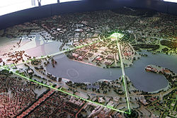
The National Triangle was a significant feature of Walter Burley Griffin's Plan for Canberra. The apices of the triangle are Parliament House, the seat of government; the Defence Headquarters at Russell; and City Hill, representing the civilian part of Canberra. Griffin planned the city around two axes which converge in the centre of the National Triangle. The land axis connects Mount Ainslie, Capital Hill and Red Hill and extends off towards Mount Bimberi the Australian Capital Territory's highest mountain. The water axis runs at right angles to the land axis along the length of Lake Burley Griffin.

The southern shore of Lake Burley Griffin bisects the National Triangle forming a smaller Triangle known as the Parliamentary Zone bounded by Kings and Commonwealth Avenues.

Consistent with Walter Burley Griffin's Garden City design, the National Triangle is characterised by streets lined with large deciduous trees, and buildings set in expanses of grassed parkland. Consequently, it has a very open feel and buildings are located several minutes walk away from one another. It was Griffin's original intention for more grand government buildings to be located within the precinct, but these have not eventuated as yet.

A map of inner Canberra showing the Parliamentary Triangle in red. Inner-canberra-triangle MJC01.png
A map of inner Canberra showing the Parliamentary Triangle in red.

Development within the National Triangle is strictly controlled by the National Capital Authority, an agency of the Commonwealth Government (not the ACT Government) within the Department of Infrastructure, Transport, Regional Development and Communications.

Significant buildings and monuments

The area covered by the National Triangle corresponds largely with the suburb of Parkes. Parliament House and Old Parliament House are the most significant features within the National Triangle. Other buildings significant to the design and symmetry of the Triangle are the High Court and the National Gallery, located near Lake Burley Griffin, forward of Old Parliament House and to the east, and the National Library and Questacon located forward of Old Parliament House and to the west. Commonwealth Place is located at the centre of the lakeshore and Commonwealth Park and Kings Park line the opposite shore of the lake.

Other significant buildings within the precinct include the Department of the Treasury and the John Gorton Building. The National Carillon, a gift from the British government which marked 50 years since the establishment of Canberra, is located on Queen Elizabeth II Island. [1] The National Rose Garden is located beside old Parliament House and the Aboriginal Tent Embassy is located in front of it. Reconciliation Place, a monument to reconciliation between Australia's indigenous people and the settler population is located near the High Court. The National Archives and 'West Block' – old departmental offices – are located behind the Old Parliament House near Kings Avenue and Commonwealth Avenue respectively. Other government departments, such as the Attorney-General's Department and the Department of Prime Minister and Cabinet are located in the suburb of Barton nearby.

Connection with Washington, D.C., and Brasília

Brasilia has a triangular shape. Map of Brasilia and surrounding areas.svg
Brasília has a triangular shape.
The United States Capitol sits on top of a triangle in Washington, D.C. Washington DC map1.png
The United States Capitol sits on top of a triangle in Washington, D.C.

There are similarities with the design of Canberra and that of Washington, D.C., and Brasília. The three cities consist of triangles that link up the House of Government with other monuments and important places.

Restaurants and recreation

The National Triangle has several dining and recreational facilities which cater to the large number of departmental employees, tourists and Canberra locals. Cafes are located in the National Gallery and National Library. 'The Lobby' located near Old Parliament House and the 'Café in the House' located within it, are restaurants popular with public servants. The Café in the House has recently developed into a trendy bar popular with younger public servants on Friday evenings. The 'Waters Edge' is a restaurant located in Commonwealth Place.

See also

External reference

35°18′S149°08′E / 35.300°S 149.133°E / -35.300; 149.133

Related Research Articles

<span class="mw-page-title-main">Canberra</span> Capital city of Australia

Canberra is the capital city of Australia. Founded following the federation of the colonies of Australia as the seat of government for the new nation, it is Australia's largest inland city and the eighth-largest Australian city overall. The city is located at the northern end of the Australian Capital Territory at the northern tip of the Australian Alps, the country's highest mountain range. As of June 2023, Canberra's estimated population was 466,566.

<span class="mw-page-title-main">Walter Burley Griffin</span> American architect and landscape architect (1876–1937)

Walter Burley Griffin was an American architect and landscape architect. He designed Canberra, Australia's capital city, the New South Wales towns of Griffith and Leeton, and the Sydney suburb of Castlecrag.

The history of Canberra details the development of the city of Canberra from the time before European settlement to the city's planning by the Chicago architect Walter Burley Griffin in collaboration with Marion Mahony Griffin, and its subsequent development to the present day.

<span class="mw-page-title-main">Lake Burley Griffin</span> Man-made lake in Canberra, Australia

Lake Burley Griffin is an artificial lake in the centre of Canberra, the capital of Australia. It was completed in 1963 after the Molonglo River, which ran between the city centre and Parliamentary Triangle, was dammed. It is named after Walter Burley Griffin, the American architect who won the competition to design the city of Canberra.

<span class="mw-page-title-main">Civic, Australian Capital Territory</span> Suburb of Canberra, Australian Capital Territory

Civic is the city centre or central business district of Canberra. "Civic" is a common name for the district, but it is also called Civic Centre, City Centre, Canberra City and Canberra, and its official division name is City.

<span class="mw-page-title-main">Yarralumla, Australian Capital Territory</span> Suburb of Canberra, Australia

Yarralumla is a large inner south suburb of Canberra, the capital city of Australia. Located approximately 3.5 km (2.2 mi) south-west of the city, Yarralumla extends along the south-west bank of Lake Burley Griffin from Scrivener Dam to Commonwealth Avenue.

<span class="mw-page-title-main">Parkes, Australian Capital Territory</span> Suburb of Canberra, Australia

Parkes is an inner southern suburb of the Canberra Central district of Canberra, located within the Australian Capital Territory of Australia. Located southeast of the Canberra central business district, Parkes contains the Parliamentary Triangle and many of the national monuments of Australia's capital city.

<span class="mw-page-title-main">Capital Hill, Australian Capital Territory</span> City center and the location of Parliament House, Canberra, Australia

Capital Hill is the location of Parliament House, Canberra, at the south apex of the land axis of the Parliamentary Triangle.

<span class="mw-page-title-main">Barton, Australian Capital Territory</span> Suburb of Canberra, Australia

Barton is a suburb of Canberra, Australian Capital Territory, Australia. At the 2021 census, Barton had a population of 1,946 people.

<span class="mw-page-title-main">National Carillon</span> Bell instrument in Canberra, Australia

The National Carillon is a large carillon situated on Queen Elizabeth II Island in Lake Burley Griffin, central Canberra, in the Australian Capital Territory, Australia. The carillon is managed and maintained by the National Capital Authority on behalf of the Commonwealth of Australia. It has 57 bells, ranging nearly 5 octaves from the 6,108 kg (13,466 lb) bass bell in F# to the 8 kg (18 lb) treble bell in D.

<span class="mw-page-title-main">Kingston, Australian Capital Territory</span> Suburb of Canberra, Australia

Kingston is the oldest and one of the most densely populated suburbs of Canberra, Australian Capital Territory, Australia. The suburb is named after Charles Cameron Kingston, the former Premier of South Australia and minister in the first Australian Commonwealth Government. It is adjacent to the suburbs of Barton, Fyshwick, Griffith and Manuka. The suburb of Kingston is situated about 4 km from the centre of Canberra.

<span class="mw-page-title-main">Albert Hall, Canberra</span>

The Albert Hall is a hall in Canberra, Australia, used for entertainment. It is on Commonwealth Avenue between Commonwealth Bridge and the Hotel Canberra in the suburb of Yarralumla.

<span class="mw-page-title-main">Anzac Parade, Canberra</span> Road in Canberra, Australia

Anzac Parade is a significant road and thoroughfare in the Australian capital Canberra, used for ceremonial occasions and the site of many major military memorials.

<span class="mw-page-title-main">Kings Park, Canberra</span>

Kings Park is a park in Canberra, Australia on the shore of Lake Burley Griffin.

<span class="mw-page-title-main">Commonwealth Avenue (Canberra)</span> Road in Canberra, Australia

Commonwealth Avenue is a major road in Canberra, Australian Capital Territory, Australia. It connects Civic with South Canberra. Specifically, it runs between City Hill and Capital Hill.

<span class="mw-page-title-main">Kings Avenue, Canberra</span> Road in Canberra, Australia

Kings Avenue is a road in Canberra which goes between New Parliament House, across Lake Burley Griffin at the Kings Avenue Bridge, to Russell near the Australian-American Monument..

<span class="mw-page-title-main">Queen Elizabeth II Island</span> Island in Canberra, Australia

Queen Elizabeth II Island, formerly Aspen Island, is an artificial island located within Lake Burley Griffin, in Canberra, Australian Capital Territory, Australia. It lies within the Parliamentary Triangle.

The Australian Centre for Christianity and Culture is a national Christian ecumenical centre, established in 1993, in Canberra, the national capital of Australia. It encourages dialogue and cooperation among Christian churches and between Christianity and other faiths, as well as exploring issues relating to reconciliation in Australia and the interface between Christian faith and Australian culture. The Centre is a research centre within Charles Sturt University, through a formal partnership established in 1998 between the Anglican Diocese of Canberra and Goulburn and the University and is affiliated with United Theological College and St Mark's National Theological Centre.

<span class="mw-page-title-main">History of Lake Burley Griffin</span> Notable events in the history of the artificial water body in Canberra

The history of Lake Burley Griffin, an artificial body of water in Canberra, the capital of Australia, is highly complex. Following its initial design in the 1910s, extensive political disputes occurred until it was finally built in the 1960s.

<span class="mw-page-title-main">Hotel Kurrajong</span> Hotel in Canberra, Australia

Hotel Kurrajong Canberra is a heritage-listed hotel located in the Canberra suburb of Barton, Australian Capital Territory, close to Parliament House and national institutions within the Parliamentary Triangle precinct. The Hotel has a strong association with Australia's political history, most notably as the residence of Prime Minister Ben Chifley throughout his parliamentary career, including his term in office from 1945-1949. In 1951, Chifley suffered a fatal heart attack in room 205 at Hotel Kurrajong.

References

  1. "National Carillon". National Capital Authority. Retrieved 5 June 2022.