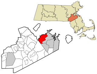
Milton is a town in Norfolk County, Massachusetts, United States and an affluent suburb of Boston. The population was 28,630 at the 2020 census. Milton is the birthplace of former U.S. President George H. W. Bush, and architect Buckminster Fuller. Milton was ranked by Money as the 2nd, 7th, 8th, and 17th best place to live in the United States in 2011, 2009, 2019, 2021, and 2022 respectively.
The Neponset River is a river in eastern Massachusetts in the United States. Its headwaters are at the Neponset Reservoir in Foxborough, near Gillette Stadium. From there, the Neponset meanders generally northeast for about 29 miles (47 km) to its mouth at Dorchester Bay between Quincy and the Dorchester section of Boston, near the painted gas tank.

The Granite Railway was one of the first railroads in the United States, built to carry granite from Quincy, Massachusetts, to a dock on the Neponset River in Milton. From there boats carried the heavy stone to Charlestown for construction of the Bunker Hill Monument. The Granite Railway is popularly termed the first commercial railroad in the United States, as it was the first chartered railway to evolve into a common carrier without an intervening closure. The last active quarry closed in 1963; in 1985, the Metropolitan District Commission purchased 22 acres (8.9 ha), including Granite Railway Quarry, as the Quincy Quarries Reservation.

The National Register of Historic Places is a United States federal official list of places and sites considered worthy of preservation. In the state of Massachusetts, there are over 4,300 listings, representing about 5% of all NRHP listings nationwide and the second-most of any U.S. state, behind only New York. Listings appear in all 14 Massachusetts counties.

Mother Brook is a stream that flows from the Charles River in Dedham, Massachusetts, to the Neponset River in the Hyde Park section of Boston, Massachusetts. Mother Brook was also known variously as East Brook and Mill Creek in earlier times. Digging the brook made Boston and some surrounding communities an island, accessible only by crossing over water, making Mother Brook "Massachusetts' Panama Canal."

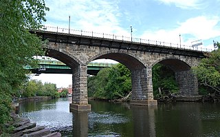
Canton Viaduct is a blind arcade cavity wall in Canton, Massachusetts, built in 1834–35 for the Boston and Providence Railroad.
The Division Street Bridge is an historic roadway and sidewalk stone arch bridge in Pawtucket, Rhode Island, carrying Division Street over the Seekonk River. The structure was built in 1875–1877 at a cost of USD$95,000. It is a nine-span stone and brick bridge with a total length of about 450 feet (140 m), making it the "finest and longest" stone arch bridge in the state. It is said to be a symbolic icon of the unity of the two neighborhoods, which are divided by the river, coming together as the Town of Pawtucket. The bridge was listed on the National Register of Historic Places in 1983. Although it may be "functionally obsolete" relative to traffic patterns and in need of repairs, it is considered to be architecturally and historically significant.

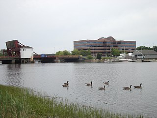
The Dorchester-Milton Lower Mills Industrial District is a historic district on both sides of the Neponset River in the Dorchester area of Boston and in the town of Milton, Massachusetts. It encompasses an industrial factory complex, most of which was historically associated with the Walter Baker & Company, the first major maker of chocolate products in the United States. The industrial buildings of the district were built between about 1868 and 1947. They were listed as part of the district on the National Register of Historic Places in 1980, with a slight enlargement in 2001. The buildings have been adapted for mixed industrial/retail/residential use.

The Neponset Valley Parkway is a historic parkway in southern Boston and Milton, Massachusetts, United States. It is a connecting parkway in the Greater Boston area's network, providing a connection between the Blue Hills Reservation, Neponset River Reservation, and the Stony Brook Reservation. The parkway was constructed between 1898 and 1929 with design assistance from Charles Eliot and the Olmsted Brothers. It was listed on the National Register of Historic Places in 2005.

The Stony Brook Reservation Parkways are a group of historic parkways in Boston and Dedham, Massachusetts. They provide access to and within the Stony Brook Reservation, a Massachusetts state park. The roadways and the park are administered by the Massachusetts Department of Conservation and Recreation, a successor to the Metropolitan District Commission, which oversaw their construction. The roads consist of the Dedham, Enneking, and Turtle Pond Parkways and West Boundary Road. Two roads within the park, Smithfield Road and Reservation Road, are listed as non-contributing properties. The park roads were built between 1894 and 1956, and were listed on the National Register of Historic Places in 2006.

The Truman Parkway is a historic parkway in Milton and southern Boston, Massachusetts. It runs along the southern boundary of a portion of the Neponset River Reservation and serves as a connection between the Neponset Valley Parkway and the Blue Hills Parkway. The parkway was built in 1931 and added to the National Register of Historic Places in 2005.

The Veterans of Foreign Wars Parkway is a historic parkway in Boston, Massachusetts. The southern terminus of the parkway is at Washington Street at the Dedham-West Roxbury border, from where it travels north and then east, ending at a junction with Centre Street, near the Arnold Arboretum. The highway is almost entirely contained within the West Roxbury neighborhood, although it passes through part of the Chestnut Hill neighborhood near its junction with the West Roxbury Parkway. Most of its length, from Spring Street in West Roxbury to its eastern end, is administered by the Massachusetts Department of Conservation and Recreation (DCR), a successor to the Metropolitan District Commission (MDC) which oversaw the road's construction. The parkway was built in stages between 1930 and 1942, and was designed to provide a parkway connection from the Upper Charles River Reservation to other MDC parks via the West Roxbury Parkway. The DCR portion of the road was listed on the National Register of Historic Places in 2005. The road formerly carried the designation for U.S. Route 1.
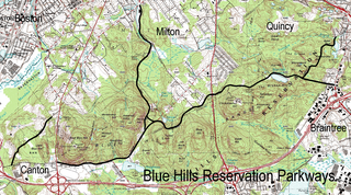
The Blue Hills Reservation Parkways are a network of historic parkways in and around the Blue Hills Reservation, a Massachusetts state park south of Boston, Massachusetts. It consists of six roadways that provide circulation within the park, and that join the park to two connecting parkways, the Blue Hills Parkway and the Furnace Brook Parkway. The roadway network was designed by Charles Eliot in the 1890s, except for Green Street, which was added to the network in the 1940s. The parkways were added to the National Register of Historic Places in 2003.

The Blackstone Viaduct, or the New York & New England Railroad Viaduct is a historic viaduct in Blackstone, Massachusetts. The viaduct was built in 1872 by the Boston, Hartford and Erie Railroad and the American Bridge Company. The viaduct is 1,600 feet (490 m) long structure, consisting of masonry arches and earthen embankments in the Massachusetts portion of the village of Waterford. It runs from the Blackstone River in the east to a still-watered section of the defunct Blackstone Canal to the west. The most prominent portion of the structure is an 800-foot earthen embankment running west from the river that is 25 feet (7.6 m) high, and then a 375-foot (114 m) multiple-arch masonry bridge constructed out of granite which was sheathed in concrete in 1918. The structure was listed on the National Register of Historic Places in 2002.

Choate Bridge (1764) is a historic stone arch bridge carrying Route 1A/Route 133 over the Ipswich River in Ipswich, Massachusetts. It is one of the oldest surviving bridges in North America, and is probably the oldest in Massachusetts. It was listed on the National Register of Historic Places in 1972 and also has been designated as a National Historic Civil Engineering Landmark.

The Sewall-Scripture House, is a historic house museum in Rockport, Massachusetts that is owned by the Sandy Bay Historical Society. The Sewall Scripture Museum features antiques, period artifacts and items of local history. The Federal style building, the only house in Rockport built out of native granite, was added to the National Register of Historic Places in 1982.

Blue Hills Parkway is a historic parkway that runs in a straight line from a crossing of the Neponset River, at the south border of Boston to the north edge of the Blue Hills Reservation in Milton, Massachusetts. It was built in 1893 to a design by the noted landscape architect, Charles Eliot, who is perhaps best known for the esplanades along the Charles River. The parkway is a connecting road between the Blue Hills Reservation and the Neponset River Reservation, and was listed on the National Register of Historic Places in 2003.

The Stone Arch Bridge is a stone arch railroad bridge in Keene, New Hampshire, United States. Built in 1847 to carry the Cheshire Railroad, it is one of the best-preserved pre-1850 stone arch bridges in the nation. The bridge was listed on the National Register of Historic Places in 2012, and the New Hampshire State Register of Historic Places in 2006. It now carries a multi-purpose rail trail.

The Sacketts Brook Stone Arch Bridge, also known locally as the Hi-Lo Biddy Stone Arch Bridge, is a historic bridge just outside the village of Putney, Vermont. It is a stone arch bridge that formerly carried Mill Street across Sacketts Brook, about 0.25 miles (0.40 km) east of United States Route 5. It was built in 1906 by James Otis Follett, an area stonemason, and is one of a few surviving examples of his work. The bridge was listed on the National Register of Historic Places in 1976.

The West Townshend Stone Arch Bridge carries Round Hill Road across Tannery Brook in the village of West Townshend, Vermont. Built about 1910, it is one of the few surviving bridges of a group built by local mason James Otis Follett in the early 20th century. It was listed on the National Register of Historic Places in 1977.


