Payette Junction, Oregon | |
|---|---|
 Payette Junction  Payette Junction | |
| Coordinates: 44°07′10″N116°56′39″W / 44.11944°N 116.94417°W | |
| Country | United States |
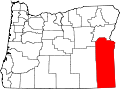
| State | Oregon |
| County | Malheur |
| Elevation | 2,146 ft (654 m) |
| Time zone | UTC-7 (Mountain (MST)) |
| • Summer (DST) | UTC-6 (MDT) |
| Area code | 541 |
| GNIS feature ID | 1129765 [1] |
Payette Junction is a highway junction and former unincorporated community in Malheur County, Oregon, United States. [1] It lies at the intersection of Oregon Route 52 and Oregon Route 201 between Ontario, Oregon, and Weiser, Idaho. It is about a mile from Payette, Idaho, on the other side of the Snake River, which marks the Oregon–Idaho border in this vicinity. [2]