Pearl Beach, St. Clair County, Michigan

Last updated

Pearl Beach, Michigan
Pearl Beach (St. Clair County), MI road signage.jpg
Road signage along Pointe Tremble Road (M-29)
Pearl Beach CDP, MI location.png
Location within St. Clair County
USA Michigan location map.svg
Red pog.svg
Pearl Beach
Location within the state of Michigan
Usa edcp location map.svg
Red pog.svg
Pearl Beach
Location within the United States
Coordinates: 42°37′26″N82°35′24″W / 42.62389°N 82.59000°W / 42.62389; -82.59000
CountryUnited States
State Michigan
County St. Clair
Township Clay
Area
[1]
  Total5.65 sq mi (14.63 km2)
  Land4.80 sq mi (12.43 km2)
  Water0.84 sq mi (2.18 km2)
Elevation
577 ft (176 m)
Population
 (2020)
  Total4,698
  Density978.75/sq mi (377.90/km2)
Time zone UTC-5 (Eastern (EST))
  Summer (DST) UTC-4 (EDT)
ZIP code(s)
48001 (Algonac)
Area code 810
FIPS code 26-63200 [2]
GNIS feature ID1624814 [3] , 2393181 [4]

Pearl Beach is an unincorporated community and census-designated place (CDP) in St. Clair County in the U.S. state of Michigan. The population of the CDP was 4,698 at the 2020 census. The community is located within Clay Township.

Contents

History

This area along the North Channel connecting Anchor Bay to the Saint Clair River was settled as early as 1796 when a dozen private land claims were made by the French. A now-defunct post office began operating here under the name Pearlbeach on August 2, 1898. Harry Bryant, who was an agent for the Detroit and St. Clair Railroad, served as the first postmaster. [5]

The Colony Tower Complex was built in Pearl Beach along the North Channel in 1925. The site is listed on the National Register of Historic Places and is also a designated Michigan State Historic Site.

Geography

Looking west along M-29 toward the ferry service to Harsens Island and M-154 M-154 signage toward Harsens Island.jpg
Looking west along M-29 toward the ferry service to Harsens Island and M-154

According to the U.S. Census Bureau, the CDP has a total area of 5.65 square miles (14.63 km2), of which 4.80 square miles (12.43 km2) is land and 0.84 square miles (2.18 km2) (14.87%) is water. [1]

The CDP consists of a narrow strip along the north side of the North Channel of the St. Clair River from the western border of Algonac to the easternmost point of land where the North Channel flows into Anchor Bay. The community is served by Algonac Community Schools to the east in the city of Algonac. [6]

The CDP also contains the unincorporated community of Pointe aux Tremble, which was settled in 1904 as a station along the railway about 3.0 miles (4.8 km) west of Algonac. [7] [8] The St. John's Marsh State Wildlife Area is a 3,060-acre (12.4 km2) state wildlife area that has small portions within Pearl Beach. [9]

Ferry service

Major highways

Demographics

Historical population
CensusPop.Note
1990 3,394
2000 3,224−5.0%
2010 2,829−12.3%
2020 4,69866.1%
U.S. Decennial Census [10]

As of the census [2] of 2000, there were 3,224 people, 1,395 households, and 980 families residing in the community. The population density was 1,514.7 inhabitants per square mile (584.8/km2). There were 1,560 housing units at an average density of 732.9 per square mile (283.0/km2). The racial makeup of the community was 98.17% White, 0.40% Native American, 0.16% Asian, 0.34% from other races, and 0.93% from two or more races. Hispanic or Latino of any race were 0.62% of the population.

There were 1,395 households, out of which 20.1% had children under the age of 18 living with them, 62.9% were married couples living together, 4.3% had a female householder with no husband present, and 29.7% were non-families. 24.8% of all households were made up of individuals, and 11.1% had someone living alone who was 65 years of age or older. The average household size was 2.31 and the average family size was 2.76.

In the community, the population was spread out, with 17.4% under the age of 18, 6.1% from 18 to 24, 23.9% from 25 to 44, 36.2% from 45 to 64, and 16.4% who were 65 years of age or older. The median age was 46 years. For every 100 females, there were 106.4 males. For every 100 females age 18 and over, there were 102.7 males.

The median income for a household in the community was $55,186, and the median income for a family was $68,583. Males had a median income of $58,542 versus $28,811 for females. The per capita income for the community was $32,320. About 0.6% of families and 3.2% of the population were below the poverty line, including 2.9% of those under age 18 and 5.2% of those age 65 or over.

Related Research Articles

<span class="mw-page-title-main">St. Clair County, Michigan</span> County in Michigan, United States

St. Clair County is a county located in the U.S. state of Michigan and bordering the west bank of the St. Clair River. As of the 2020 census, the population was 160,383. It is the 13th-most populous county in the state. The county seat is Port Huron, located at the north end of the St. Clair River at Lake Huron. The county was created September 10, 1820, and its government was organized in 1821. It is located northeast of Detroit and is included within the Detroit–Warren–Dearborn Metropolitan Statistical Area by the Office of Management and Budget. It is also considered by the State of Michigan to be a part of The Thumb, a peninsula that is surrounded by Lake Huron in the east-central area of the state. This area is sometimes dubbed the Blue Water Area.

<span class="mw-page-title-main">Lake Michigan Beach, Michigan</span> Census-designated place & unincorporated community in Michigan, United States

Lake Michigan Beach is an unincorporated community in Berrien County in the U.S. state of Michigan. It is a census-designated place (CDP) for statistical purposes, without any legal status as a municipality. The population was 1,216 at the 2010 census.

<span class="mw-page-title-main">Argentine, Michigan</span> Census-designated place & unincorporated community in Michigan, United States

Argentine is an unincorporated community and census-designated place (CDP) in Argentine Township, Genesee County, in the U.S. state of Michigan. The population was 2,685 as of the 2020 census, up from 2,525 at the 2010 census. It was first settled in 1836.

<span class="mw-page-title-main">Lake Fenton, Michigan</span> Census-designated place & unincorporated community in Michigan, United States

Lake Fenton is a census-designated place (CDP) in Fenton Charter Township, Genesee County in the U.S. state of Michigan. As of the 2010 census the population was 5,559, up from 4,876 at the 2000 census. The CDP includes the unincorporated communities of Bayport Park and Lakeside.

<span class="mw-page-title-main">Holt, Michigan</span> Census-designated place & unincorporated community in Michigan, United States

Holt is an unincorporated community and census-designated place (CDP) in Ingham County in the U.S. state of Michigan. The CDP is located within Delhi Charter Township and occupies a majority of the township. The population was 25,625 at the 2020 census, which is a significant increase from 11,315 at the 2000 census when the CDP area was significantly smaller.

<span class="mw-page-title-main">Williamstown Township, Michigan</span> Civil township in Michigan, United States

Williamstown Township is a civil township of Ingham County in the U.S. state of Michigan. As of the 2010 census, the township population was 4,978. The city of Williamston occupies the southeast corner of the township, but the two are administered autonomously.

Au Sable is an unincorporated community and census-designated place (CDP) in the U.S. state of Michigan. The population of the CDP was 1,453 at the 2020 census. The community is located within Au Sable Township at the mouth of the Au Sable River along Lake Huron.

<span class="mw-page-title-main">Bois Blanc Township, Michigan</span> Civil township in Michigan, United States

Bois Blanc Township is a civil township of Mackinac County in the U.S. state of Michigan. The population was 100 at the 2020 census. The insular township occupies Bois Blanc Island, as well as some smaller outlying islands within Lake Huron. The nearby Round Island is administered by the city of Mackinac Island.

<span class="mw-page-title-main">Harrison Township, Michigan</span> Charter township in Michigan, United States

Harrison Charter Township is a charter township of Macomb County in the U.S. state of Michigan. The population was 24,314 at the 2020 census.

<span class="mw-page-title-main">Big Bay, Michigan</span> Census-designated place & unincorporated community in Michigan, United States

Big Bay is an unincorporated community in Marquette County of the U.S. state of Michigan. It is a census-designated place (CDP) for statistical purposes and does not have any legal status as an incorporated municipality. As of the 2020 census, the CDP had a population of 257. The community is located within Powell Township near the shore of "Big Bay" on Lake Superior.

<span class="mw-page-title-main">Detroit Beach, Michigan</span> Census-designated place & unincorporated community in Michigan, United States

Detroit Beach is an unincorporated community and census-designated place (CDP) in Monroe County in the U.S. state of Michigan. The population was 1,957 at the 2020 census. The CDP is located within Frenchtown Charter Township, and as an unincorporated community, Detroit Beach has no legal autonomy of its own.

<span class="mw-page-title-main">Woodland Beach, Michigan</span> Census-designated place & unincorporated community in Michigan, United States

Woodland Beach is a census-designated place (CDP) and unincorporated community in Monroe County in the U.S. state of Michigan. The population was 1,899 at the 2020 census. The CDP is located within Frenchtown Charter Township.

<span class="mw-page-title-main">Atlanta, Michigan</span> Census-designated place & Unincorporated community in Michigan, United States

Atlanta is an unincorporated community in the U.S. state of Michigan, along the 45th parallel. It is a census-designated place (CDP) for statistical purposes and does not have any legal status as an incorporated municipality. The population was 757 at the 2000 census. It is the county seat of Montmorency County.

<span class="mw-page-title-main">Shields, Michigan</span> Census-designated place & unincorporated community in Michigan, United States

Shields is an unincorporated community in Thomas Township, Saginaw County in the U.S. state of Michigan. It is also a census-designated place (CDP) for statistical purposes, but with no legal status as an incorporated municipality. The population of the CDP was 7,035 at the 2020 census.

<span class="mw-page-title-main">Algonac, Michigan</span> City in Michigan, United States

Algonac is a city in St. Clair County of the U.S. state of Michigan. The population was 4,196 at the 2020 census.

<span class="mw-page-title-main">Casco Township, St. Clair County, Michigan</span> Civil township in Michigan, United States

Casco Township is a civil township of St. Clair County in the U.S. state of Michigan. As of the 2020 Census, the township population was 3,990.

<span class="mw-page-title-main">Clay Township, Michigan</span> Civil township in Michigan, United States

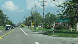
Clay Township is a civil township of St. Clair County in the U.S. state of Michigan. The population was 8,446 at the 2020 census.

<span class="mw-page-title-main">Grosse Pointe, Michigan</span> City in Michigan, United States

Grosse Pointe is a city in Wayne County in the U.S. state of Michigan. As of the 2010 census, the city had a population of 5,421.

<span class="mw-page-title-main">South Branch Township, Wexford County, Michigan</span> Civil township in Michigan, United States

South Branch Township is a civil township of Wexford County of the U.S. state of Michigan. The population was 383 at the 2010 census.

<span class="mw-page-title-main">Memphis, Michigan</span> City in Michigan, United States

Memphis is a city that straddles the border between Macomb and St. Clair counties in the U.S. state of Michigan. The population was 1,084 at the 2020 census.

References

  1. 1 2 "2020 U.S. Gazetteer Files". United States Census Bureau. Retrieved May 21, 2022.
  2. 1 2 "U.S. Census website". United States Census Bureau . Retrieved January 31, 2008.
  3. U.S. Geological Survey Geographic Names Information System: Pearl Beach, St. Clair County, Michigan
  4. U.S. Geological Survey Geographic Names Information System: Pearl Beach Census Designated Place
  5. Romig 1986, p. 433.
  6. St. Clair County RESA (2023). "Local School Districts" . Retrieved July 18, 2023.
  7. Romig 1986, p. 449.
  8. U.S. Geological Survey Geographic Names Information System: Pointe aux Tremble, Michigan
  9. Michigan Department of Natural Resources (May 2006). "St. John's Marsh State Wildlife Area" (PDF). Retrieved August 11, 2023.
  10. "Census of Population and Housing". Census.gov. Retrieved June 4, 2016.

Sources